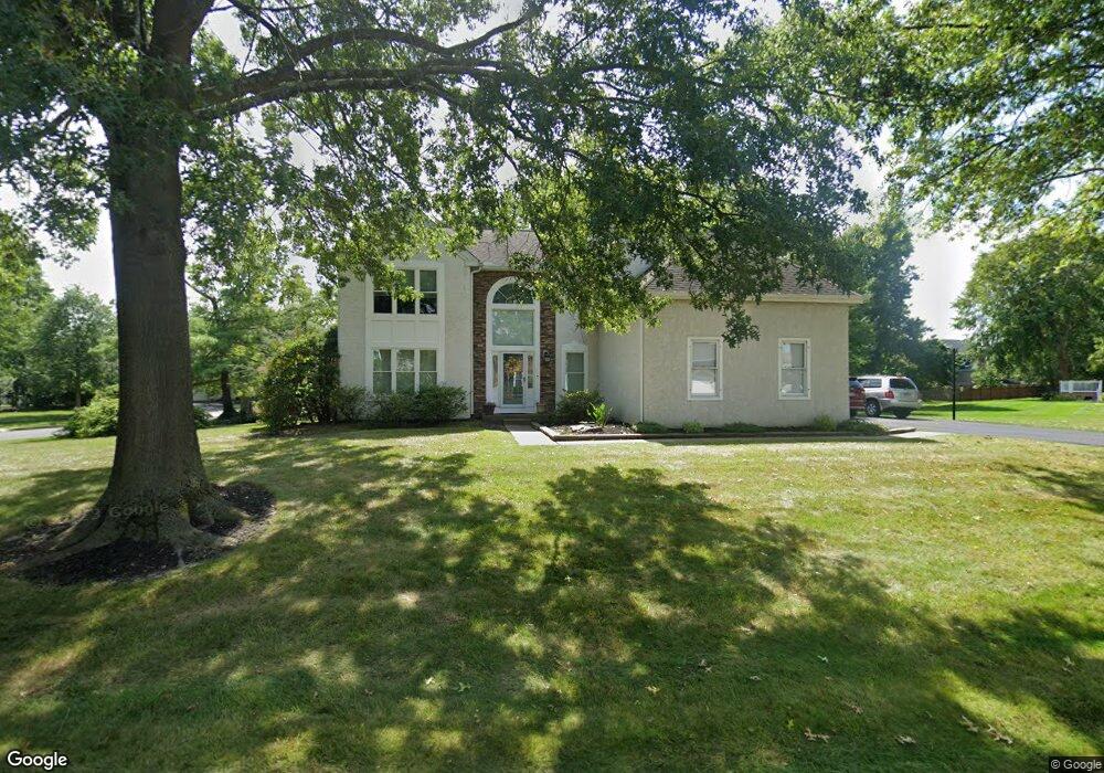
212 Norsam Dr Langhorne, PA 19047
Estimated Value: $768,819 - $828,000
4
Beds
3
Baths
2,541
Sq Ft
$318/Sq Ft
Est. Value
About This Home
This home is located at 212 Norsam Dr, Langhorne, PA 19047 and is currently estimated at $807,705, approximately $317 per square foot. 212 Norsam Dr is a home located in Bucks County with nearby schools including Pearl S. Buck Elementary School, Maple Point Middle School, and Neshaminy High School.
Ownership History
Date
Name
Owned For
Owner Type
Purchase Details
Closed on
Sep 9, 2023
Sold by
Cavallo Michael A and Cavallo Lori L
Bought by
Cavallo Lori L
Current Estimated Value
Home Financials for this Owner
Home Financials are based on the most recent Mortgage that was taken out on this home.
Original Mortgage
$229,500
Outstanding Balance
$224,633
Interest Rate
6.96%
Mortgage Type
New Conventional
Estimated Equity
$583,072
Purchase Details
Closed on
Jun 5, 2007
Sold by
Stamou Nicholas and Stamou Kathleen
Bought by
Cavallo Michael A and Cavallo Lori L
Home Financials for this Owner
Home Financials are based on the most recent Mortgage that was taken out on this home.
Original Mortgage
$389,900
Interest Rate
6.48%
Mortgage Type
Purchase Money Mortgage
Purchase Details
Closed on
Sep 13, 1990
Bought by
Stamou Nicholas and Stamou Kathleen
Create a Home Valuation Report for This Property
The Home Valuation Report is an in-depth analysis detailing your home's value as well as a comparison with similar homes in the area
Home Values in the Area
Average Home Value in this Area
Purchase History
| Date | Buyer | Sale Price | Title Company |
|---|---|---|---|
| Cavallo Lori L | -- | Wfg Lender Services | |
| Cavallo Michael A | $519,900 | Lawyers Title Insurance Corp | |
| Stamou Nicholas | $221,900 | -- |
Source: Public Records
Mortgage History
| Date | Status | Borrower | Loan Amount |
|---|---|---|---|
| Open | Cavallo Lori L | $229,500 | |
| Previous Owner | Cavallo Michael A | $389,900 |
Source: Public Records
Tax History Compared to Growth
Tax History
| Year | Tax Paid | Tax Assessment Tax Assessment Total Assessment is a certain percentage of the fair market value that is determined by local assessors to be the total taxable value of land and additions on the property. | Land | Improvement |
|---|---|---|---|---|
| 2025 | $9,675 | $44,440 | $7,840 | $36,600 |
| 2024 | $9,675 | $44,440 | $7,840 | $36,600 |
| 2023 | $9,521 | $44,440 | $7,840 | $36,600 |
| 2022 | $9,271 | $44,440 | $7,840 | $36,600 |
| 2021 | $9,271 | $44,440 | $7,840 | $36,600 |
| 2020 | $9,160 | $44,440 | $7,840 | $36,600 |
| 2019 | $8,956 | $44,440 | $7,840 | $36,600 |
| 2018 | $8,791 | $44,440 | $7,840 | $36,600 |
| 2017 | $8,567 | $44,440 | $7,840 | $36,600 |
| 2016 | $8,567 | $44,440 | $7,840 | $36,600 |
| 2015 | $8,756 | $44,440 | $7,840 | $36,600 |
| 2014 | $8,756 | $44,440 | $7,840 | $36,600 |
Source: Public Records
Map
Nearby Homes
- 770 Atkinson Ln
- 2904 Sterling Rd Unit 179
- 1707 Lynbrooke Dr Unit 120
- 462 Scott Ct
- 2602 Waterford Rd Unit 96
- 2007 Waterford Rd Unit 81
- 14303 Cornerstone Dr
- 1948 Satter Ct
- 7908 Spruce Mill Dr Unit 656
- 5801 Spruce Mill Dr Unit 450
- 647A Rose Hollow Dr Unit B
- 181 Fillmore Way
- 313 Chestnut Ct
- 1605 Covington Rd
- 650 Bayberry Ln Unit U6
- 195 Roosevelt Dr
- 210 Shady Brook Dr
- 1839 Windflower Ln
- 164 Tyler Way
- 624 Lollard Ct