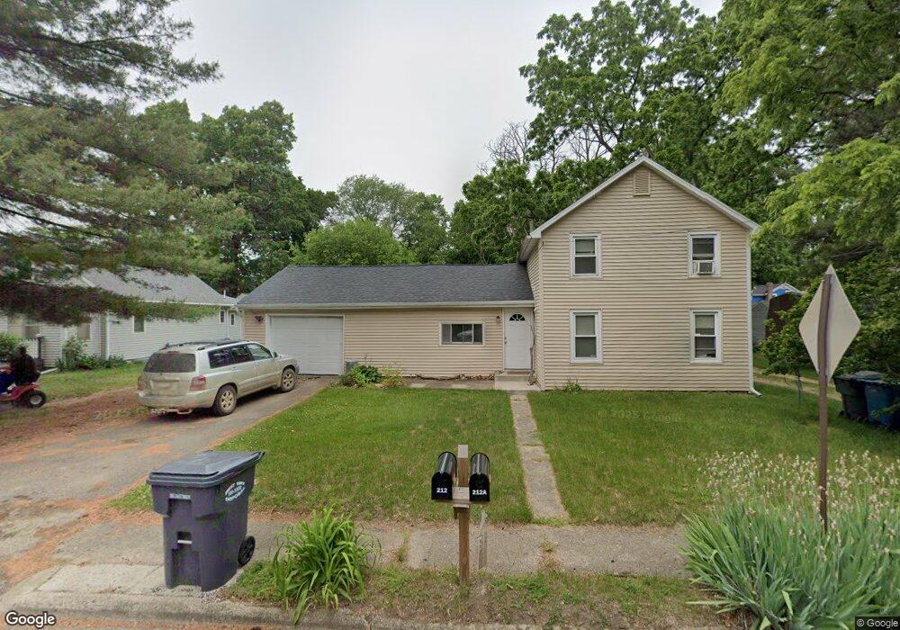
212 Roberts St Plainwell, MI 49080
Estimated Value: $169,000 - $244,000
3
Beds
2
Baths
1,632
Sq Ft
$123/Sq Ft
Est. Value
About This Home
This home is located at 212 Roberts St, Plainwell, MI 49080 and is currently estimated at $200,891, approximately $123 per square foot. 212 Roberts St is a home located in Allegan County with nearby schools including Plainwell High School and Otsego Christian Academy.
Ownership History
Date
Name
Owned For
Owner Type
Purchase Details
Closed on
Oct 19, 2013
Sold by
Tuinstra Calvin and Tuinstra Karen
Bought by
Nest Box Properties Llc
Current Estimated Value
Purchase Details
Closed on
Jun 10, 2011
Sold by
Fannie Mae
Bought by
Tuinstra Calvin and Tuinstra Karen
Purchase Details
Closed on
Jun 16, 2010
Sold by
Bac Home Loans Servicing Lp
Bought by
Federal National Mortgage Association
Purchase Details
Closed on
May 20, 2010
Sold by
Eckert John G and Eckert Judy
Bought by
Bac Home Loans Servicing Lp
Purchase Details
Closed on
Aug 25, 2008
Sold by
Eckert John
Bought by
Bemis Rich
Home Financials for this Owner
Home Financials are based on the most recent Mortgage that was taken out on this home.
Original Mortgage
$86,130
Interest Rate
5.11%
Mortgage Type
Seller Take Back
Purchase Details
Closed on
May 1, 2008
Sold by
West Bridge Properties Llc
Bought by
Eckert John G
Purchase Details
Closed on
Jul 21, 2006
Sold by
Eckert John G and Eckert Judy
Bought by
West Bridge Properties Llc
Home Financials for this Owner
Home Financials are based on the most recent Mortgage that was taken out on this home.
Original Mortgage
$87,900
Interest Rate
6.73%
Mortgage Type
Purchase Money Mortgage
Purchase Details
Closed on
Feb 27, 2003
Sold by
Hud
Bought by
Eckert John G
Home Financials for this Owner
Home Financials are based on the most recent Mortgage that was taken out on this home.
Original Mortgage
$47,250
Interest Rate
5.96%
Mortgage Type
Purchase Money Mortgage
Purchase Details
Closed on
Jul 23, 2002
Sold by
Alliance Mortgage Co
Bought by
Hud
Purchase Details
Closed on
Dec 6, 2001
Sold by
Oconnor Robbin
Bought by
Alliance Mtg Company
Purchase Details
Closed on
Jul 8, 1999
Sold by
Niedoliwka Thomas and Niedoliwka Deidre
Bought by
Oconnor Robbin
Create a Home Valuation Report for This Property
The Home Valuation Report is an in-depth analysis detailing your home's value as well as a comparison with similar homes in the area
Home Values in the Area
Average Home Value in this Area
Purchase History
| Date | Buyer | Sale Price | Title Company |
|---|---|---|---|
| Nest Box Properties Llc | -- | None Available | |
| Tuinstra Calvin | $34,900 | Attorneys Title Agency Llc | |
| Federal National Mortgage Association | -- | None Available | |
| Bac Home Loans Servicing Lp | $90,227 | None Available | |
| Bemis Rich | $86,130 | None Available | |
| Eckert John G | -- | None Available | |
| West Bridge Properties Llc | -- | Devon Title Agency | |
| Eckert John G | -- | Devon Title Agency | |
| Eckert John G | $63,000 | Metropolitan Title Company | |
| Hud | -- | -- | |
| Alliance Mtg Company | $86,277 | -- | |
| Oconnor Robbin | $87,000 | -- |
Source: Public Records
Mortgage History
| Date | Status | Borrower | Loan Amount |
|---|---|---|---|
| Previous Owner | Bemis Rich | $86,130 | |
| Previous Owner | Eckert John G | $87,900 | |
| Previous Owner | Eckert John G | $47,250 |
Source: Public Records
Tax History
| Year | Tax Paid | Tax Assessment Tax Assessment Total Assessment is a certain percentage of the fair market value that is determined by local assessors to be the total taxable value of land and additions on the property. | Land | Improvement |
|---|---|---|---|---|
| 2025 | $3,042 | $79,200 | $20,600 | $58,600 |
| 2024 | $2,750 | $73,000 | $15,200 | $57,800 |
| 2023 | $2,761 | $67,000 | $15,200 | $51,800 |
| 2022 | $2,750 | $55,900 | $11,000 | $44,900 |
| 2021 | $2,647 | $53,100 | $10,700 | $42,400 |
| 2020 | $2,613 | $48,400 | $7,500 | $40,900 |
| 2019 | $2,425 | $48,100 | $7,500 | $40,600 |
| 2018 | $0 | $41,900 | $7,500 | $34,400 |
| 2017 | $0 | $37,500 | $3,900 | $33,600 |
| 2016 | $0 | $36,900 | $4,700 | $32,200 |
| 2015 | -- | $36,900 | $4,700 | $32,200 |
| 2014 | -- | $36,700 | $6,900 | $29,800 |
| 2013 | -- | $31,500 | $6,900 | $24,600 |
Source: Public Records
Map
Nearby Homes
- 721 E Bridge St
- 936 James St
- 317 E Chart St
- 404 Park St
- 233 Washington Ave
- 140 W 1st Ave
- 426 W Bridge St
- V/L Bronson Ave
- 830 Miller Rd Unit 26.98 Acres
- 551 W Bridge St
- 1046 Bronson Ave
- 770 Miller Rd
- 1170 W Bridge St
- 355 12th St
- 1036 Sir Knight Rd
- 575 Rushing Dr
- 1224 102nd Ave
- 1248 Keith St
- 10809 N 12th St
- 1038 Allen Ct
Your Personal Tour Guide
Ask me questions while you tour the home.