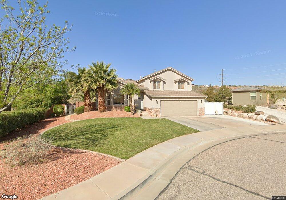
212 S 2020 Cir E St. George, UT 84790
Estimated Value: $491,000 - $564,000
4
Beds
3
Baths
2,015
Sq Ft
$255/Sq Ft
Est. Value
About This Home
This home is located at 212 S 2020 Cir E, St. George, UT 84790 and is currently estimated at $514,603, approximately $255 per square foot. 212 S 2020 Cir E is a home located in Washington County with nearby schools including Panorama School, Fossil Ridge Intermediate School, and Pine View Middle School.
Ownership History
Date
Name
Owned For
Owner Type
Purchase Details
Closed on
Nov 29, 2006
Sold by
Carr William Edward and Car Heather L
Bought by
Roll Marina and Meadows Anthony
Current Estimated Value
Purchase Details
Closed on
Nov 28, 2006
Sold by
Rull Marina and Meadows Anthony
Bought by
Rull Marina and Meadows Anthony
Create a Home Valuation Report for This Property
The Home Valuation Report is an in-depth analysis detailing your home's value as well as a comparison with similar homes in the area
Home Values in the Area
Average Home Value in this Area
Purchase History
| Date | Buyer | Sale Price | Title Company |
|---|---|---|---|
| Roll Marina | -- | First American Title | |
| Rull Marina | -- | Southern Utah Title Co |
Source: Public Records
Tax History Compared to Growth
Tax History
| Year | Tax Paid | Tax Assessment Tax Assessment Total Assessment is a certain percentage of the fair market value that is determined by local assessors to be the total taxable value of land and additions on the property. | Land | Improvement |
|---|---|---|---|---|
| 2025 | $1,773 | $260,150 | $66,825 | $193,325 |
| 2023 | $1,832 | $273,680 | $59,400 | $214,280 |
| 2022 | $1,956 | $274,890 | $60,115 | $214,775 |
| 2021 | $1,750 | $366,700 | $92,000 | $274,700 |
| 2020 | $1,604 | $316,500 | $69,000 | $247,500 |
| 2019 | $1,573 | $303,200 | $69,000 | $234,200 |
| 2018 | $1,486 | $147,895 | $0 | $0 |
| 2017 | $1,475 | $142,560 | $0 | $0 |
| 2016 | $1,529 | $136,675 | $0 | $0 |
| 2015 | $1,470 | $126,060 | $0 | $0 |
| 2014 | $1,381 | $119,185 | $0 | $0 |
Source: Public Records
Map
Nearby Homes
- 236 S 2020 Cir E
- 232 S Acantilado Cir
- 2144 E 220 Cir S
- 0 S Mall Dr
- 145 N Mall Dr Unit 33
- 145 N Mall Dr Unit 35
- 145 N Mall Dr Unit 59
- 145 N Mall Dr Unit 57
- 0 Null Unit 25-258376
- 1684 E 290 S
- 210 N Mall Dr Unit 46
- 210 N Mall Dr Unit 64
- 210 N Mall Dr Unit 65
- 210 N Mall Dr Unit 86
- 210 N Mall Dr Unit 96
- 1646 E 90 Cir S
- 0 Paisley Way Unit 24-253758
- 2911 E Snowberry Dr Unit 56
- 2911 E Snowberry Dr
- 0 Tagans Way Unit 24-253774
- 212 S 2020 East Cir
- 204 S 2020 East Cir
- 224 S 2020 East Cir
- 224 S 2020 Cir E
- 204 S 2020 Cir E
- 201 S 2020 Cir E
- 201 S 2020 East Cir
- 236 S 2020 East Cir
- 217 S 2020 East Cir
- 217 S 2020 Cir E
- 209 S 2020 Cir E
- 209 S 2020 East Cir
- 233 S 2020 East Cir
- 233 S 2020 Cir E
- 2016 E 180 South Cir
- 145 S Mall Dr
- 145 S Mall Dr Unit 21
- 145 S Mall Dr Unit 24
- 145 S Mall Dr Unit 2
- 2010 2010 E