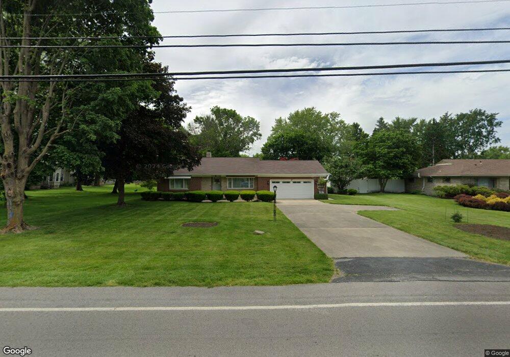
2120 Buckland Ave Fremont, OH 43420
Estimated Value: $161,000 - $180,000
2
Beds
1
Bath
1,096
Sq Ft
$154/Sq Ft
Est. Value
About This Home
This home is located at 2120 Buckland Ave, Fremont, OH 43420 and is currently estimated at $168,907, approximately $154 per square foot. 2120 Buckland Ave is a home located in Sandusky County with nearby schools including Fremont Ross High School, St. Joseph School, and Bishop Hoffman Catholic School - This is St Joe's School now.
Ownership History
Date
Name
Owned For
Owner Type
Purchase Details
Closed on
Jun 13, 2006
Sold by
Almendinger Jon Todd and Almendinger Kathy L
Bought by
Behee Susanna R
Current Estimated Value
Home Financials for this Owner
Home Financials are based on the most recent Mortgage that was taken out on this home.
Original Mortgage
$104,000
Outstanding Balance
$61,519
Interest Rate
6.68%
Mortgage Type
Purchase Money Mortgage
Estimated Equity
$107,388
Purchase Details
Closed on
Jul 22, 2005
Sold by
Popa Patricia K
Bought by
Almendinger Jon Todd
Home Financials for this Owner
Home Financials are based on the most recent Mortgage that was taken out on this home.
Original Mortgage
$65,000
Interest Rate
5.74%
Mortgage Type
Fannie Mae Freddie Mac
Purchase Details
Closed on
Feb 2, 2004
Sold by
Howe Elsie and Antesberger Elsie
Bought by
Almendinger Jon Todd and Almendinger Megan Nicole
Create a Home Valuation Report for This Property
The Home Valuation Report is an in-depth analysis detailing your home's value as well as a comparison with similar homes in the area
Home Values in the Area
Average Home Value in this Area
Purchase History
| Date | Buyer | Sale Price | Title Company |
|---|---|---|---|
| Behee Susanna R | $97,500 | None Available | |
| Almendinger Jon Todd | $44,250 | Quentin Haines Title | |
| Almendinger Jon Todd | -- | -- |
Source: Public Records
Mortgage History
| Date | Status | Borrower | Loan Amount |
|---|---|---|---|
| Open | Behee Susanna R | $104,000 | |
| Previous Owner | Almendinger Jon Todd | $65,000 |
Source: Public Records
Tax History Compared to Growth
Tax History
| Year | Tax Paid | Tax Assessment Tax Assessment Total Assessment is a certain percentage of the fair market value that is determined by local assessors to be the total taxable value of land and additions on the property. | Land | Improvement |
|---|---|---|---|---|
| 2024 | $2,044 | $52,120 | $12,950 | $39,170 |
| 2023 | $2,044 | $44,520 | $11,060 | $33,460 |
| 2022 | $1,867 | $44,520 | $11,060 | $33,460 |
| 2021 | $1,923 | $44,520 | $11,060 | $33,460 |
| 2020 | $1,648 | $37,350 | $11,060 | $26,290 |
| 2019 | $1,646 | $37,350 | $11,060 | $26,290 |
| 2018 | $1,602 | $37,350 | $11,060 | $26,290 |
| 2017 | $1,452 | $33,920 | $11,060 | $22,860 |
| 2016 | $1,273 | $33,920 | $11,060 | $22,860 |
| 2015 | $1,249 | $33,920 | $11,060 | $22,860 |
| 2014 | $1,334 | $34,720 | $10,990 | $23,730 |
| 2013 | $1,306 | $34,720 | $10,990 | $23,730 |
Source: Public Records
Map
Nearby Homes
- 2484 Buckland Ave
- 1719 Buckland Ave
- 1485 Autumn Woods Dr
- 1420 Center St
- 10 Meadowbrook Dr
- 10 Meadowbrook Ln
- 64 River Run Dr Unit J
- 1611 Mcpherson Blvd
- 1028 June St
- 1013 Whittlesey St
- 905 Twinn St
- 135 Briarwood Cir
- 1015 Hayes Ave
- 1037 Buckland Ave
- 815 South St
- 515 Everett Rd
- 616 S Wood St
- 1818 Finley Dr
- 350 Conner Dr
- 625 Bush Place
- 2108 Buckland Ave
- 2200 Buckland Ave
- 2141 Martin Ave
- 2135 Martin Ave
- 2127 Martin Ave
- 2113 Buckland Ave
- 2127 Buckland Ave
- 2226 Buckland Ave
- 2104 Buckland Ave
- 2105 Buckland Ave
- 2119 Martin Ave
- 2214 Buckland Ave
- 2025 Buckland Ave
- 2102 Buckland Ave
- 2215 Buckland Ave
- 2144 Martin Ave
- 2134 Martin Ave
- 2150 Martin Ave
- 2052 Old Plank Rd
- 2113 Martin Ave