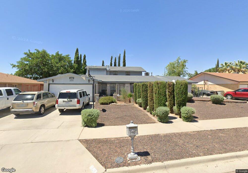
2121 Sea Palm Dr El Paso, TX 79936
Glen Cove NeighborhoodEstimated Value: $313,000 - $423,607
--
Bed
2
Baths
3,778
Sq Ft
$96/Sq Ft
Est. Value
About This Home
This home is located at 2121 Sea Palm Dr, El Paso, TX 79936 and is currently estimated at $362,652, approximately $95 per square foot. 2121 Sea Palm Dr is a home located in El Paso County with nearby schools including Tierra Del Sol Elementary School, J M Hanks High School, and EL PASO LEADERSHIP ACADEMY - MIDDLE EAST.
Ownership History
Date
Name
Owned For
Owner Type
Purchase Details
Closed on
Aug 1, 2008
Sold by
Dal Patricia R and Rodarte Patricia
Bought by
Dal Patricia R
Current Estimated Value
Home Financials for this Owner
Home Financials are based on the most recent Mortgage that was taken out on this home.
Original Mortgage
$160,000
Interest Rate
6.42%
Mortgage Type
Credit Line Revolving
Create a Home Valuation Report for This Property
The Home Valuation Report is an in-depth analysis detailing your home's value as well as a comparison with similar homes in the area
Home Values in the Area
Average Home Value in this Area
Purchase History
| Date | Buyer | Sale Price | Title Company |
|---|---|---|---|
| Dal Patricia R | -- | First American |
Source: Public Records
Mortgage History
| Date | Status | Borrower | Loan Amount |
|---|---|---|---|
| Closed | Dal Patricia R | $160,000 |
Source: Public Records
Tax History Compared to Growth
Tax History
| Year | Tax Paid | Tax Assessment Tax Assessment Total Assessment is a certain percentage of the fair market value that is determined by local assessors to be the total taxable value of land and additions on the property. | Land | Improvement |
|---|---|---|---|---|
| 2025 | $5,756 | $374,855 | $39,828 | $335,027 |
| 2024 | $5,756 | $343,602 | -- | -- |
| 2023 | $5,667 | $312,365 | $0 | $0 |
| 2022 | $8,818 | $283,968 | $0 | $0 |
| 2021 | $8,391 | $258,153 | $25,831 | $232,322 |
| 2020 | $8,116 | $256,957 | $22,254 | $234,703 |
| 2018 | $7,184 | $257,542 | $22,254 | $235,288 |
| 2017 | $6,419 | $246,011 | $22,254 | $223,757 |
| 2016 | $5,836 | $225,669 | $22,254 | $203,415 |
| 2015 | $3,638 | $225,669 | $22,254 | $203,415 |
| 2014 | $3,638 | $225,947 | $22,254 | $203,693 |
Source: Public Records
Map
Nearby Homes
- 2604 Anise Dr
- 1913 Seagull Dr
- 1868 Tom Bolt Dr
- 2308 Tom Watson Ct
- 2348 Sea Side Dr
- 11013 Bob Stone Dr
- 11016 Bob Stone Dr
- 11012 Bob Stone Dr
- 2009 Bobby Jones Dr Unit B
- 2001 Bobby Jones Dr Unit A
- 1817 Hugh Royer Place
- 11008 Johnny Miller Dr
- 1901 Bobby Jones Dr
- 2101 E Glen Dr
- 11276 Skipper Dr
- 11201 Skipper Dr
- 11132 Wharf Cove Dr
- 1804 Jerry Abbott St
- 2325 Ken Venturi Ln
- 2825 Wong Place Unit A/D
- 2115 Sea Palm Dr
- 2125 Sea Palm Dr
- 2524 Anise Dr
- 2528 Anise Dr
- 2520 Anise Dr
- 2111 Sea Palm Dr
- 2131 Sea Palm Dr
- 2120 Sea Palm Dr
- 2124 Sea Palm Dr
- 2532 Anise Dr
- 2116 Sea Palm Dr
- 2128 Sea Palm Dr
- 2516 Anise Dr
- 2112 Sea Palm Dr
- 2105 Sea Palm Dr
- 2137 Sea Palm Dr
- 2137 Sea Palm Dr Unit 1
- 2536 Anise Dr
- 2132 Sea Palm Dr
- 2525 Anise Dr