S
Seller's Agent in 2025
Stefano Belmonte
Better Homes & Gardens Real Estate
(219) 487-2814
1 in this area
20 Total Sales


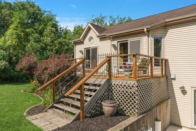

You won't find another home like this-welcome to a truly exceptional property that blends high-end construction with thoughtful design and unbeatable features. Spanning 4,500+ square feet of beautifully finished living space, this home includes a fully finished walk-out basement, providing seamless access to the expansive backyard-perfect for entertaining or quiet enjoyment. Situated on a large lot with a ginormous front yard, this property includes a long private driveway and attached 3-car garage, offering ample parking and curb appeal. On the main floor, you'll find two generously sized bedrooms, each with private walk-outs to freshly stained decks, offering serene outdoor retreats and sweeping views. One of the main-floor bedroom offers a built-in, custom murphy bed as well. This home was built with quality and longevity in mind, featuring: Brand new tankless hot water heater New AC unit (2022) Newer furnace Whole-house backup generator Three sump pumps for added peace of mind The kitchen is a chef's dream, showcasing brand new double ovens, custom-built cabinetry, and recessed hard-wired lighting that brings both elegance and functionality. Other highlights include: Massive bedrooms with high ceilings Stunning panoramic views A large lot ideal for gatherings, events, or relaxing in nature This is more than a home-it's a rare gemstone that offers luxury, practicality, and craftsmanship at every turn. Don't miss your chance to own this extraordinary property.
Last Agent to Sell the Property
Better Homes & Gardens Real Estate License #475209324 Listed on: 09/30/2025
| Date | Type | Sale Price | Title Company |
|---|---|---|---|
| Warranty Deed | $515,000 | None Listed On Document | |
| Warranty Deed | $34,000 | -- | |
| Warranty Deed | $18,500 | -- |
| Date | Status | Loan Amount | Loan Type |
|---|---|---|---|
| Previous Owner | $412,000 | New Conventional |
| Date | Event | Price | List to Sale | Price per Sq Ft |
|---|---|---|---|---|
| 11/18/2025 11/18/25 | Sold | $515,000 | -6.3% | $110 / Sq Ft |
| 10/14/2025 10/14/25 | Pending | -- | -- | -- |
| 09/30/2025 09/30/25 | For Sale | $549,900 | -- | $118 / Sq Ft |
| Year | Tax Paid | Tax Assessment Tax Assessment Total Assessment is a certain percentage of the fair market value that is determined by local assessors to be the total taxable value of land and additions on the property. | Land | Improvement |
|---|---|---|---|---|
| 2025 | $2,744 | $29,786 | $9,864 | $19,922 |
| 2024 | $2,744 | $29,786 | $9,864 | $19,922 |
| 2023 | $3,459 | $29,786 | $9,864 | $19,922 |
| 2022 | $3,459 | $21,105 | $8,455 | $12,650 |
| 2021 | $3,154 | $21,103 | $8,454 | $12,649 |
| 2020 | $2,886 | $21,103 | $8,454 | $12,649 |
| 2019 | $3,109 | $29,634 | $7,045 | $22,589 |
| 2018 | $3,011 | $29,634 | $7,045 | $22,589 |
| 2017 | $2,998 | $29,634 | $7,045 | $22,589 |
| 2016 | $4,062 | $27,917 | $5,636 | $22,281 |
| 2015 | $4,249 | $27,917 | $5,636 | $22,281 |
| 2014 | $4,155 | $27,917 | $5,636 | $22,281 |
| 2013 | $3,891 | $29,918 | $5,636 | $24,282 |
S
Seller's Agent in 2025
Stefano Belmonte
Better Homes & Gardens Real Estate
(219) 487-2814
1 in this area
20 Total Sales

Buyer's Agent in 2025
Jody Sholeen
john greene Realtor
(773) 401-3441
1 in this area
141 Total Sales
Source: Midwest Real Estate Data (MRED)
MLS Number: 12484392
APN: 32-34-207-001-0000
Disclaimer: Certain information contained herein is derived from information provided by parties other than Homes.com. All information provided is deemed reliable, but is not guaranteed to be accurate and should be independently verified.
![]() Based on information submitted to the MLS GRID. All data is obtained from various sources and may not have been verified by broker or MLS GRID. Supplied Open House Information is subject to change without notice. All information should be independently reviewed and verified for accuracy. Properties may or may not be listed by the office/agent presenting the information. Some IDX listings have been excluded from this website.
Based on information submitted to the MLS GRID. All data is obtained from various sources and may not have been verified by broker or MLS GRID. Supplied Open House Information is subject to change without notice. All information should be independently reviewed and verified for accuracy. Properties may or may not be listed by the office/agent presenting the information. Some IDX listings have been excluded from this website.
Based on information submitted to the MLS GRID
Ask me questions while you tour the home.