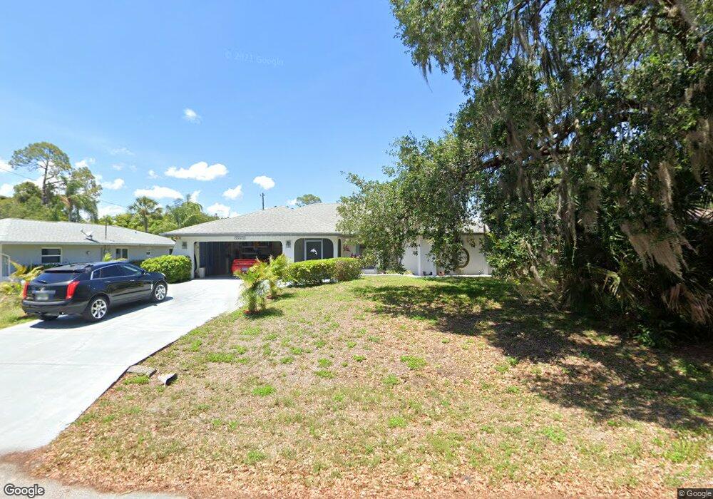
21230 Hubbard Ave Port Charlotte, FL 33952
Estimated Value: $308,497 - $372,000
3
Beds
2
Baths
1,981
Sq Ft
$169/Sq Ft
Est. Value
About This Home
This home is located at 21230 Hubbard Ave, Port Charlotte, FL 33952 and is currently estimated at $334,124, approximately $168 per square foot. 21230 Hubbard Ave is a home located in Charlotte County with nearby schools including Neil Armstrong Elementary School, Murdock Middle School, and Port Charlotte High School.
Ownership History
Date
Name
Owned For
Owner Type
Purchase Details
Closed on
Feb 22, 2017
Sold by
Bailey Charles R and Bailey Jois M
Bought by
Mueller Terry L
Current Estimated Value
Purchase Details
Closed on
Aug 10, 2011
Sold by
Gigliotti Frank A and Frank A Gigliotti Family Trust
Bought by
Bowman Theodore and Yacura Jo Ann
Home Financials for this Owner
Home Financials are based on the most recent Mortgage that was taken out on this home.
Original Mortgage
$101,171
Interest Rate
4.75%
Mortgage Type
FHA
Purchase Details
Closed on
Dec 8, 2000
Sold by
Gigliotti Frank A
Bought by
Gigliotti Frank A
Create a Home Valuation Report for This Property
The Home Valuation Report is an in-depth analysis detailing your home's value as well as a comparison with similar homes in the area
Home Values in the Area
Average Home Value in this Area
Purchase History
| Date | Buyer | Sale Price | Title Company |
|---|---|---|---|
| Mueller Terry L | $248,000 | Attorney | |
| Bowman Theodore | $111,800 | Coastal Security Title Inc | |
| Gigliotti Frank A | -- | -- |
Source: Public Records
Mortgage History
| Date | Status | Borrower | Loan Amount |
|---|---|---|---|
| Previous Owner | Bowman Theodore | $101,171 |
Source: Public Records
Tax History Compared to Growth
Tax History
| Year | Tax Paid | Tax Assessment Tax Assessment Total Assessment is a certain percentage of the fair market value that is determined by local assessors to be the total taxable value of land and additions on the property. | Land | Improvement |
|---|---|---|---|---|
| 2023 | $1,738 | $108,908 | $0 | $0 |
| 2022 | $1,726 | $105,736 | $0 | $0 |
| 2021 | $1,707 | $102,656 | $0 | $0 |
| 2020 | $1,661 | $101,239 | $0 | $0 |
| 2019 | $1,575 | $98,963 | $0 | $0 |
| 2018 | $1,437 | $97,118 | $0 | $0 |
| 2017 | $1,416 | $95,120 | $0 | $0 |
| 2016 | $1,401 | $93,164 | $0 | $0 |
| 2015 | $1,386 | $92,516 | $0 | $0 |
| 2014 | $1,361 | $91,782 | $0 | $0 |
Source: Public Records
Map
Nearby Homes
- 1321 Newton St
- 1370 Kenmore St
- 21271 Quesada Ave
- 21192 Quesada Ave
- 1529 Newton St
- 1370 Dewitt St
- 1233 Dewhurst St
- 1409 Yorkshire St
- 1402 Viscaya Dr
- 1418 Viscaya
- 1205 Yorkshire St
- 1150 Winston St
- 1329 Harbor Blvd
- 1505 Kenmore St
- 1394 Viscaya Dr
- 21051 Cascade Ave
- 1490 Yorkshire St
- 21068 Exmore Ave
- 21161 Knollwood Ave
- 1425 Harbor Blvd
- 21222 Hubbard Ave
- 21238 Hubbard Ave
- 21229 Wardell Ave
- 21237 Wardell Ave
- 21221 Wardell Ave
- 21221 Hubbard Ave
- 21237 Hubbard Ave
- 1329 Newton St
- 1337 Newton St
- 21262 Hubbard Ave
- 21253 Hubbard Ave
- 1345 Newton St
- 21230 Covington Ave
- 1362 Newton St
- 21242 Wardell Ave
- 21218 Wardell Ave
- 21246 Covington Ave
- 21261 Wardell Ave
- 21210 Wardell Ave
- 1330 Kenmore St