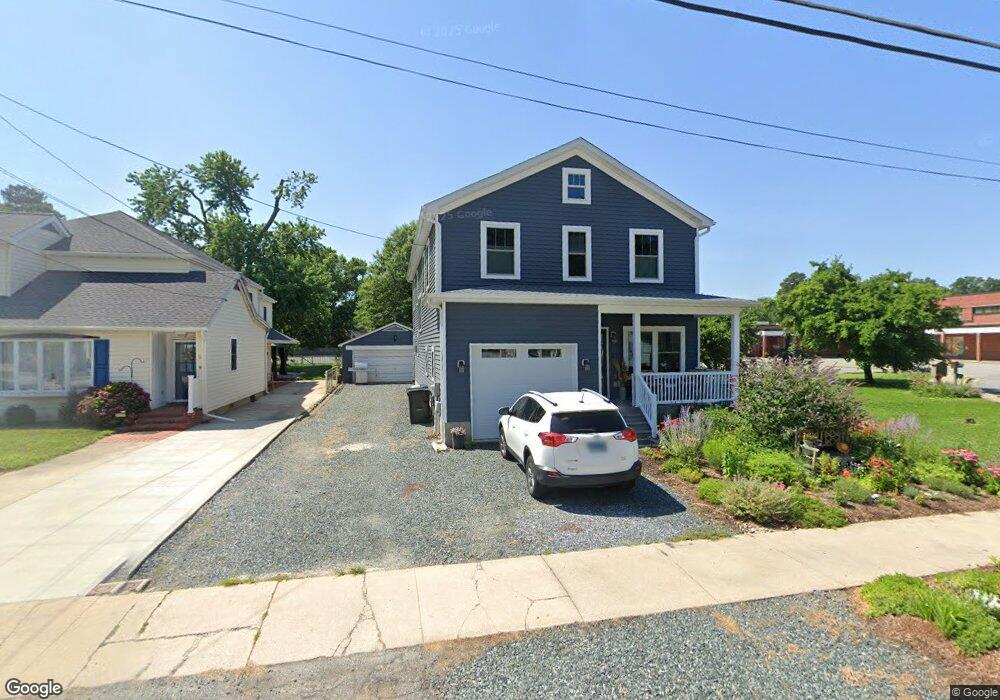
21233 W Sharp St Rock Hall, MD 21661
Estimated Value: $387,000 - $554,000
Studio
1
Bath
2,478
Sq Ft
$190/Sq Ft
Est. Value
About This Home
This home is located at 21233 W Sharp St, Rock Hall, MD 21661 and is currently estimated at $471,181, approximately $190 per square foot. 21233 W Sharp St is a home located in Kent County with nearby schools including Kent County Middle School and Kent County High School.
Ownership History
Date
Name
Owned For
Owner Type
Purchase Details
Closed on
Jul 15, 2020
Sold by
Resele Robert S
Bought by
Resele Robert S and Resele Laurie M
Current Estimated Value
Home Financials for this Owner
Home Financials are based on the most recent Mortgage that was taken out on this home.
Original Mortgage
$250,000
Outstanding Balance
$221,683
Interest Rate
3.1%
Mortgage Type
Construction
Estimated Equity
$249,498
Purchase Details
Closed on
Sep 10, 1998
Sold by
Leary Deborah L
Bought by
Resele Robert S
Purchase Details
Closed on
Dec 7, 1993
Sold by
Parker Harriet M
Bought by
Leary Deborah L
Create a Home Valuation Report for This Property
The Home Valuation Report is an in-depth analysis detailing your home's value as well as a comparison with similar homes in the area
Purchase History
| Date | Buyer | Sale Price | Title Company |
|---|---|---|---|
| Resele Robert S | -- | None Available | |
| Resele Robert S | $49,500 | -- | |
| Leary Deborah L | $45,000 | -- |
Source: Public Records
Mortgage History
| Date | Status | Borrower | Loan Amount |
|---|---|---|---|
| Open | Resele Robert S | $250,000 |
Source: Public Records
Tax History
| Year | Tax Paid | Tax Assessment Tax Assessment Total Assessment is a certain percentage of the fair market value that is determined by local assessors to be the total taxable value of land and additions on the property. | Land | Improvement |
|---|---|---|---|---|
| 2025 | $5,742 | $389,300 | $0 | $0 |
| 2024 | $5,435 | $356,600 | $80,700 | $275,900 |
| 2023 | $5,197 | $341,000 | $0 | $0 |
| 2022 | $4,893 | $325,400 | $0 | $0 |
| 2021 | $870 | $309,800 | $80,700 | $229,100 |
| 2020 | $870 | $118,000 | $0 | $0 |
| 2019 | $1,738 | $117,900 | $0 | $0 |
| 2018 | $1,713 | $117,800 | $80,700 | $37,100 |
| 2017 | $1,713 | $117,800 | $0 | $0 |
| 2016 | -- | $117,800 | $0 | $0 |
| 2015 | $1,922 | $120,600 | $0 | $0 |
| 2014 | $1,922 | $120,600 | $0 | $0 |
Source: Public Records
Map
Nearby Homes
- 21133 Striper Run
- 21131 Striper Run
- 21124 Striper Run
- 21235 Rock Hall Ave
- 21186 Chesapeake Ave
- 21103 Striper Run
- 0 Judefind Ave Unit MDKE2001688
- 5807 Blue Claw Ct
- 21090 W Sharp St Unit 133
- 21090 W Sharp St Unit 112
- 5898 Williams St
- 0 Sharp St Unit MDKE2005760
- 5883 Williams St
- 5916 N Main St
- 21305 Haven Rd
- 5827 S Hawthorne Ave
- 5786 S Hawthorne Ave
- 21447 E Sharp St
- 21336 Haven Rd
- 21745 Centennial Ln
- 21239 W Sharp St
- 21243 W Sharp St
- 21230 W Sharp St
- 21224 W Sharp St
- 21236 W Sharp St
- 21218 W Sharp St
- 5702 Liberty St
- 21212 E Sharp St
- 0 Liberty St Unit 1003704736
- 5720 Liberty St
- 21212 W Sharp St
- 5740 Liberty St
- 5734 Liberty St
- 5694 Liberty St
- 21204 W Sharp St
- 21143 Striper Run
- 21197 W Sharp St
- 21244 Chesapeake Ave
- 21200 W Sharp St
- 5705 Liberty St
Your Personal Tour Guide
Ask me questions while you tour the home.