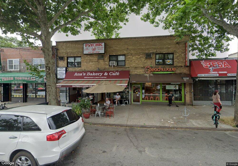
2125 Williamsbridge Rd Bronx, NY 10461
Morris Park NeighborhoodEstimated Value: $890,867
Studio
--
Bath
6,000
Sq Ft
$148/Sq Ft
Est. Value
About This Home
This home is located at 2125 Williamsbridge Rd, Bronx, NY 10461 and is currently estimated at $890,867, approximately $148 per square foot. 2125 Williamsbridge Rd is a home located in Bronx County with nearby schools including P.S. 108 Philip J Abinanti, J.H.S. 144 Michelangelo, and Children's Aid College Preparatory Charter School.
Ownership History
Date
Name
Owned For
Owner Type
Purchase Details
Closed on
Jul 6, 2011
Sold by
Rizzotto Joseph
Bought by
2125 Williamsbridge Realty Llc
Current Estimated Value
Purchase Details
Closed on
Jun 9, 2011
Sold by
Luongo Phyllis and Rizzotto Joseph
Bought by
Rizzotto Joseph
Purchase Details
Closed on
Jun 3, 2011
Sold by
Luongo Phyllis and Pelham Pkwy Holding Co
Bought by
Luongo Phyllis and Rizzotto Joseph
Create a Home Valuation Report for This Property
The Home Valuation Report is an in-depth analysis detailing your home's value as well as a comparison with similar homes in the area
Home Values in the Area
Average Home Value in this Area
Purchase History
| Date | Buyer | Sale Price | Title Company |
|---|---|---|---|
| 2125 Williamsbridge Realty Llc | -- | -- | |
| 2125 Williamsbridge Realty Llc | -- | -- | |
| Rizzotto Joseph | $477,500 | -- | |
| Rizzotto Joseph | $477,500 | -- | |
| Luongo Phyllis | -- | -- | |
| Luongo Phyllis | -- | -- |
Source: Public Records
Tax History
| Year | Tax Paid | Tax Assessment Tax Assessment Total Assessment is a certain percentage of the fair market value that is determined by local assessors to be the total taxable value of land and additions on the property. | Land | Improvement |
|---|---|---|---|---|
| 2025 | $38,207 | $378,540 | $121,500 | $257,040 |
| 2024 | $38,207 | $360,720 | $121,500 | $239,220 |
| 2023 | $35,307 | $331,650 | $121,500 | $210,150 |
| 2022 | $35,000 | $334,350 | $121,500 | $212,850 |
| 2021 | $32,724 | $306,000 | $121,500 | $184,500 |
| 2020 | $34,280 | $325,350 | $121,500 | $203,850 |
| 2019 | $34,207 | $325,350 | $121,500 | $203,850 |
| 2018 | $32,370 | $334,800 | $121,500 | $213,300 |
| 2017 | $30,677 | $320,850 | $121,500 | $199,350 |
| 2016 | $29,329 | $333,450 | $121,500 | $211,950 |
| 2015 | $18,947 | $330,300 | $121,500 | $208,800 |
| 2014 | $18,947 | $250,200 | $121,500 | $128,700 |
Source: Public Records
Map
Nearby Homes
- 1194 Lydig Ave
- 1054 Lydig Ave
- 1100 Neill Ave
- 1059 Neill Ave
- 1214 Pelham Pkwy S
- 1942 Haight Ave
- 1922 Hering Ave
- 1178 Astor Ave
- - Lydig Ave
- 1917 Haight Ave
- 1912 Haight Ave
- 2019 Colden Ave
- 1065 Stell Place
- 1116 Rhinelander Ave
- 2037 Radcliff Ave
- 1863 Williamsbridge Rd
- 2129 Muliner Ave
- 1242 Pawnee Place
- 2165 Mathews Ave Unit 5H
- 2165 Matthews Ave Unit 4A
- 2125 Williamsbridge Rd Unit 2
- 2125-2127 Williamsbridge Rd
- 2133 Williamsbridge Rd
- 2121-2123 Williamsbridge Rd
- 2121 Williamsbridge Rd
- 2135 Williamsbridge Rd
- 2128 Tomlinson Ave
- 2126 Tomlinson Ave
- 2117 Williamsbridge Rd
- 2122 Tomlinson Ave
- 2132 Tomlinson Ave
- 2118 Tomlinson Ave
- 2137-2141 Williamsbridge Rd
- 2115 Williamsbridge Rd
- 2116 Tomlinson Ave
- 2134 Tomlinson Ave
- 2111-2113 Williamsbridge Rd
- 2111 Williamsbridge Rd
- 2114 Tomlinson Ave
- 2138 Tomlinson Ave
Your Personal Tour Guide
Ask me questions while you tour the home.