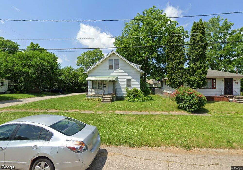
2126 Howard Ave Flint, MI 48503
South Parks NeighborhoodEstimated Value: $48,000 - $59,782
3
Beds
2
Baths
1,241
Sq Ft
$44/Sq Ft
Est. Value
About This Home
This home is located at 2126 Howard Ave, Flint, MI 48503 and is currently estimated at $54,946, approximately $44 per square foot. 2126 Howard Ave is a home located in Genesee County with nearby schools including Freeman Elementary School, Flint Southwestern Classical Academy, and International Academy of Flint (K-12).
Ownership History
Date
Name
Owned For
Owner Type
Purchase Details
Closed on
Apr 13, 2021
Sold by
Jackson Williams Sandra
Bought by
Jackson Williams Sandra and Jackson Steven Lewis
Current Estimated Value
Purchase Details
Closed on
Apr 7, 2021
Sold by
Jackson Kristal and Estate Of Willie Louis Jackson
Bought by
Jackson Williams Sandra
Purchase Details
Closed on
Oct 28, 2020
Sold by
Jackson Williams Sandra
Bought by
Jackson Williams Sandra and Jackson Steven Lewis
Purchase Details
Closed on
May 10, 2004
Sold by
Jackson Willie L and Jackson Ada
Bought by
Jackson Willie and Jackson Kristal
Create a Home Valuation Report for This Property
The Home Valuation Report is an in-depth analysis detailing your home's value as well as a comparison with similar homes in the area
Home Values in the Area
Average Home Value in this Area
Purchase History
| Date | Buyer | Sale Price | Title Company |
|---|---|---|---|
| Jackson Williams Sandra | -- | None Available | |
| Jackson Williams Sandra | -- | None Available | |
| Jackson Williams Sandra | -- | None Available | |
| Jackson Williams Sandra | -- | None Available | |
| Jackson Willie | -- | First American Title Ins Co |
Source: Public Records
Tax History Compared to Growth
Tax History
| Year | Tax Paid | Tax Assessment Tax Assessment Total Assessment is a certain percentage of the fair market value that is determined by local assessors to be the total taxable value of land and additions on the property. | Land | Improvement |
|---|---|---|---|---|
| 2025 | $1,241 | $17,500 | $0 | $0 |
| 2024 | $1,166 | $14,700 | $0 | $0 |
| 2023 | $1,146 | $12,500 | $0 | $0 |
| 2022 | $0 | $10,900 | $0 | $0 |
| 2021 | $1,123 | $9,500 | $0 | $0 |
| 2020 | $844 | $9,300 | $0 | $0 |
| 2019 | $668 | $8,100 | $0 | $0 |
| 2018 | $789 | $7,700 | $0 | $0 |
| 2017 | $775 | $0 | $0 | $0 |
| 2016 | $772 | $0 | $0 | $0 |
| 2015 | -- | $0 | $0 | $0 |
| 2014 | -- | $0 | $0 | $0 |
| 2012 | -- | $7,900 | $0 | $0 |
Source: Public Records
Map
Nearby Homes
- 2221 Howard Ave
- 2224 Crocker Ave
- 2121 Dwight Ave
- 2029 Aitken Ave
- 2010 Crocker Ave
- 1110 Pingree Ave
- 2050 Ferris Ave
- 420 Pingree Ave
- 2618 Pinetree Dr
- 1601 Wayne St
- 133 E Oakley St
- 1628 Broad Ct
- 1917 Whittlesey St
- 1937 Chelan St
- 213 E Lakeview Ave
- 3115 Circle Dr
- 1840 Mcphail St
- 2910 Shawnee Ave
- 9211 Owen St
- 115 E Livingston Dr
- 2124 Howard Ave
- 2118 Howard Ave
- 2202 Howard Ave
- 2127 Crocker Ave
- 2125 Crocker Ave
- 2123 Crocker Ave
- 2206 Howard Ave
- 2117 Crocker Ave
- 2127 Howard Ave
- 2205 Crocker Ave
- 2201 Howard Ave
- 2119 Howard Ave
- 2110 Howard Ave
- 2113 Howard Ave
- 2205 Howard Ave
- 2111 Crocker Ave
- 2209 Crocker Ave
- 2126 Crocker Ave
- 2121 Howard Ave
- 2109 Howard Ave