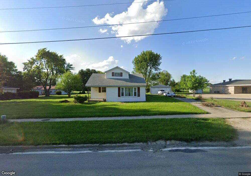
2129 Madison Ave Charleston, IL 61920
Estimated Value: $89,000 - $234,267
2
Beds
2
Baths
1,962
Sq Ft
$70/Sq Ft
Est. Value
About This Home
This home is located at 2129 Madison Ave, Charleston, IL 61920 and is currently estimated at $137,817, approximately $70 per square foot. 2129 Madison Ave is a home located in Coles County with nearby schools including Charleston High School and Charleston Christian Academy.
Ownership History
Date
Name
Owned For
Owner Type
Purchase Details
Closed on
Apr 26, 2021
Sold by
Stanley David Edward
Bought by
Stanley Michael Eric
Current Estimated Value
Purchase Details
Closed on
Nov 9, 2018
Sold by
Stanley Peter D
Bought by
Stanley David E and Stanley Peter D
Purchase Details
Closed on
Feb 4, 2015
Sold by
David E Stanley
Bought by
Stanley Peter D
Home Financials for this Owner
Home Financials are based on the most recent Mortgage that was taken out on this home.
Original Mortgage
$40,000
Outstanding Balance
$31,716
Interest Rate
4.75%
Mortgage Type
New Conventional
Estimated Equity
$106,101
Create a Home Valuation Report for This Property
The Home Valuation Report is an in-depth analysis detailing your home's value as well as a comparison with similar homes in the area
Home Values in the Area
Average Home Value in this Area
Purchase History
| Date | Buyer | Sale Price | Title Company |
|---|---|---|---|
| Stanley Michael Eric | -- | None Available | |
| Stanley David E | -- | None Available | |
| Stanley Peter D | $50,000 | -- |
Source: Public Records
Mortgage History
| Date | Status | Borrower | Loan Amount |
|---|---|---|---|
| Open | Stanley Peter D | $40,000 |
Source: Public Records
Tax History Compared to Growth
Tax History
| Year | Tax Paid | Tax Assessment Tax Assessment Total Assessment is a certain percentage of the fair market value that is determined by local assessors to be the total taxable value of land and additions on the property. | Land | Improvement |
|---|---|---|---|---|
| 2024 | $1,739 | $28,404 | $11,473 | $16,931 |
| 2023 | $1,669 | $25,940 | $10,478 | $15,462 |
| 2022 | $1,664 | $25,512 | $10,305 | $15,207 |
| 2021 | $1,279 | $24,484 | $9,890 | $14,594 |
| 2020 | $1,212 | $25,368 | $6,681 | $18,687 |
| 2019 | $1,235 | $24,484 | $6,448 | $18,036 |
| 2018 | $2,219 | $24,484 | $6,448 | $18,036 |
| 2017 | $2,190 | $24,484 | $6,448 | $18,036 |
| 2016 | $2,171 | $24,484 | $6,448 | $18,036 |
| 2015 | $1,386 | $24,484 | $6,448 | $18,036 |
| 2014 | $1,386 | $24,484 | $6,448 | $18,036 |
| 2013 | $1,386 | $24,484 | $6,448 | $18,036 |
Source: Public Records
Map
Nearby Homes
- 18 Miller Ave
- Lot 55 Tippecanoe Ave
- 29 Miller Ave
- 1520 Harrison Ave
- 1201 Monroe Ave
- 109 N 12th St
- 1013 Monroe Ave
- Lot 35 Tanglewood Dr
- Lot 28 Tanglewood Dr
- Lot 67 Hawthorne Dr
- Lot 65 Hawthorne Dr
- Lot 60 Hawthorne Dr
- Lot 52 Hawthorne Dr
- Lot 47 Hawthorne Dr
- Lot 43 Hawthorne Dr
- Lot 63 Hawthorne Dr
- Lot 59 Hawthorne Dr
- Lot 49 Hawthorne Dr
- Lot 45 Hawthorne Dr
- 6 Brosam Dr
- 2121 Madison Ave
- 2115 Madison Ave
- 2200 Madison Ave
- 2109 Madison Ave
- 2130 Madison Ave
- 2103 Madison Ave
- 2211 Madison Ave
- 2210 Madison Ave
- 1817 Madison Ave
- 402 Treeline Dr
- 1811 Madison Ave
- 408 Treeline Dr
- 2281 Madison Ave
- 414 Treeline Dr
- 2325 Madison Ave
- 1850 Madison Ave
- 420 Treeline Dr
- 1807 Madison Ave
- 426 Treeline Dr
- 2228 Country View Dr