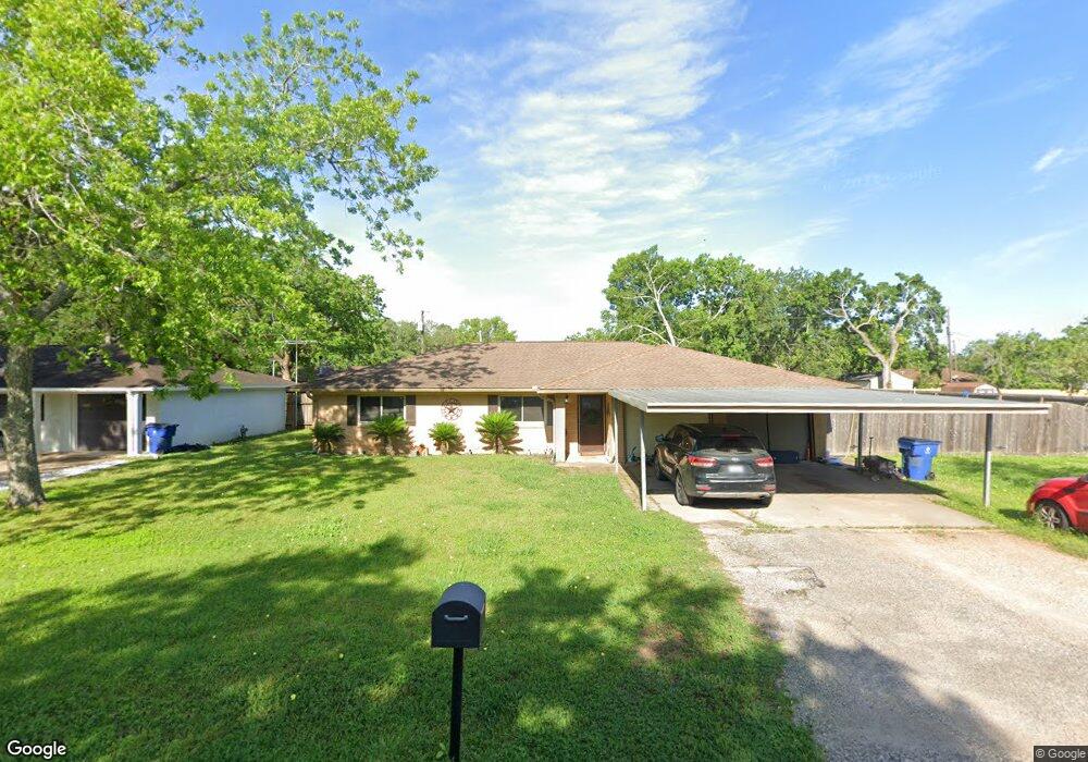
213 Avenue F Brazoria, TX 77422
Estimated Value: $214,000 - $237,000
3
Beds
2
Baths
1,608
Sq Ft
$140/Sq Ft
Est. Value
About This Home
This home is located at 213 Avenue F, Brazoria, TX 77422 and is currently estimated at $225,002, approximately $139 per square foot. 213 Avenue F is a home located in Brazoria County.
Ownership History
Date
Name
Owned For
Owner Type
Purchase Details
Closed on
Mar 18, 2015
Sold by
Kainer William James and Kainer Lynda Irene
Bought by
Evolution Financial Group Ltd
Current Estimated Value
Purchase Details
Closed on
May 12, 2006
Sold by
Hud
Bought by
Oakes Shawn and Jackson Staci A
Home Financials for this Owner
Home Financials are based on the most recent Mortgage that was taken out on this home.
Original Mortgage
$75,050
Interest Rate
6.4%
Mortgage Type
Fannie Mae Freddie Mac
Purchase Details
Closed on
Dec 12, 2005
Sold by
Wells Fargo Bank Na
Bought by
Hud
Purchase Details
Closed on
Dec 6, 2005
Sold by
Reynolds Russell W
Bought by
Wells Fargo Bank Na
Purchase Details
Closed on
Apr 5, 2001
Sold by
Wood Kenneth D and Wood Kathryn M
Bought by
Reynolds Russell W
Home Financials for this Owner
Home Financials are based on the most recent Mortgage that was taken out on this home.
Original Mortgage
$67,467
Interest Rate
7.13%
Create a Home Valuation Report for This Property
The Home Valuation Report is an in-depth analysis detailing your home's value as well as a comparison with similar homes in the area
Home Values in the Area
Average Home Value in this Area
Purchase History
| Date | Buyer | Sale Price | Title Company |
|---|---|---|---|
| Evolution Financial Group Ltd | -- | Stewart Title | |
| Oakes Shawn | -- | First American Title | |
| Hud | -- | None Available | |
| Wells Fargo Bank Na | $65,946 | -- | |
| Reynolds Russell W | -- | -- |
Source: Public Records
Mortgage History
| Date | Status | Borrower | Loan Amount |
|---|---|---|---|
| Previous Owner | Oakes Shawn | $75,050 | |
| Previous Owner | Reynolds Russell W | $67,467 |
Source: Public Records
Tax History Compared to Growth
Tax History
| Year | Tax Paid | Tax Assessment Tax Assessment Total Assessment is a certain percentage of the fair market value that is determined by local assessors to be the total taxable value of land and additions on the property. | Land | Improvement |
|---|---|---|---|---|
| 2025 | $2,500 | $205,356 | $16,780 | $218,240 |
| 2023 | $2,500 | $169,715 | $15,100 | $222,300 |
| 2022 | $3,485 | $154,286 | $13,320 | $153,530 |
| 2021 | $3,306 | $140,260 | $11,540 | $128,720 |
| 2020 | $3,193 | $136,440 | $10,660 | $125,780 |
| 2019 | $2,995 | $131,090 | $8,440 | $122,650 |
| 2018 | $2,738 | $106,670 | $8,440 | $98,230 |
| 2017 | $2,832 | $106,670 | $8,440 | $98,230 |
| 2016 | $2,832 | $106,670 | $8,440 | $98,230 |
| 2014 | $1,900 | $85,740 | $8,440 | $77,300 |
Source: Public Records
Map
Nearby Homes
- 523 Lazy Ln
- 307 Avenue G
- 229 Yaupon Dr
- 232 Magnolia St
- 0 Pecan Dr
- 409 Carlton St
- 1208 S Brooks St
- 706 E New York St
- 549 E New York St
- 230 E New York St
- 34654 Fm 521 Rd
- 8922 Fm 521 Rd
- 4773 County Road 652
- 310 E Texas St
- 401 E Texas St
- 0 Cr-747a
- TBD Cr-318
- 320 Cr-320
- 0 Cr-318 Unit 18304666
- TBD Cr-318 Tract 7c