Estimated Value: $234,000 - $268,000
4
Beds
3
Baths
2,169
Sq Ft
$117/Sq Ft
Est. Value
About This Home
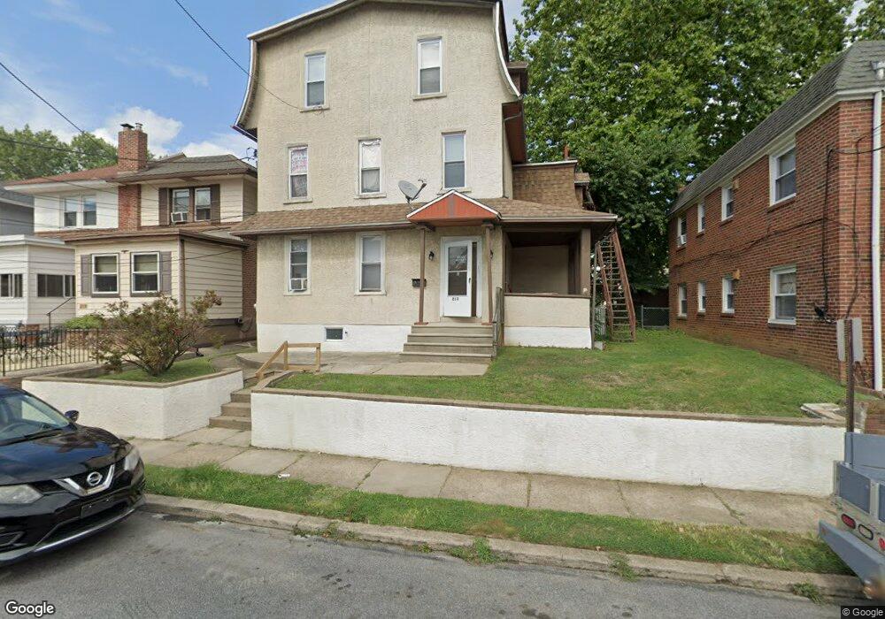
This home is located at 213 Blunston Ave, Darby, PA 19023 and is currently estimated at $254,000, approximately $117 per square foot. 213 Blunston Ave is a home located in Delaware County with nearby schools including Harris School, Academy Park High School, and Liberty Baptist Academy.
Ownership History
Date
Name
Owned For
Owner Type
Purchase Details
Closed on
Dec 27, 2005
Sold by
Mcintyre Joseph James and Mcintyre Michael K
Bought by
Mcintyre Michael
Current Estimated Value
Home Financials for this Owner
Home Financials are based on the most recent Mortgage that was taken out on this home.
Original Mortgage
$90,000
Interest Rate
8.75%
Mortgage Type
Purchase Money Mortgage
Purchase Details
Closed on
Dec 19, 2005
Sold by
Mcintyre Joseph and Reichard Scot
Bought by
Mcintyre Michael and Mcintyre Joseph
Home Financials for this Owner
Home Financials are based on the most recent Mortgage that was taken out on this home.
Original Mortgage
$90,000
Interest Rate
8.75%
Mortgage Type
Purchase Money Mortgage
Create a Home Valuation Report for This Property
The Home Valuation Report is an in-depth analysis detailing your home's value as well as a comparison with similar homes in the area
Home Values in the Area
Average Home Value in this Area
Purchase History
| Date | Buyer | Sale Price | Title Company |
|---|---|---|---|
| Mcintyre Michael | $53,420 | None Available | |
| Mcintyre Michael | -- | None Available |
Source: Public Records
Mortgage History
| Date | Status | Borrower | Loan Amount |
|---|---|---|---|
| Closed | Mcintyre Michael | $90,000 |
Source: Public Records
Tax History Compared to Growth
Tax History
| Year | Tax Paid | Tax Assessment Tax Assessment Total Assessment is a certain percentage of the fair market value that is determined by local assessors to be the total taxable value of land and additions on the property. | Land | Improvement |
|---|---|---|---|---|
| 2025 | $4,999 | $110,380 | $20,840 | $89,540 |
| 2024 | $4,999 | $110,380 | $20,840 | $89,540 |
| 2023 | $4,866 | $110,380 | $20,840 | $89,540 |
| 2022 | $4,681 | $110,380 | $20,840 | $89,540 |
| 2021 | $6,447 | $110,380 | $20,840 | $89,540 |
| 2020 | $4,921 | $77,420 | $17,170 | $60,250 |
| 2019 | $4,744 | $77,420 | $17,170 | $60,250 |
| 2018 | $4,639 | $77,420 | $0 | $0 |
| 2017 | $4,553 | $77,420 | $0 | $0 |
| 2016 | $425 | $77,420 | $0 | $0 |
| 2015 | $425 | $77,420 | $0 | $0 |
| 2014 | $425 | $77,420 | $0 | $0 |
Source: Public Records
Map
Nearby Homes
- 222 Collingdale Ave
- 164 Wayne Ave
- 149 Wayne Ave
- 1011 Andrews Ave
- 1025 Andrews Ave
- 126 Hansen Terrace
- 308 Clifton Ave
- 50 Foster Ave
- 44 High St
- 933 Bedford Ave
- 924 Pitman Ave
- 118 Juliana Terrace
- 921 Pitman Ave
- 81 Florence Ave
- 230 Felton Ave
- 605 Andrews Ave
- 235 Felton Ave
- 539 Pershing Ave
- 71 Burnside Ave
- 515 Andrews Ave
- 205 Blunston Ave
- 215 Blunston Ave
- 921 Macdade Blvd
- 217 Blunston Ave
- 919 Macdade Blvd
- 219 Blunston Ave
- 917 Macdade Blvd
- 929 Macdade Blvd
- 201 Blunston Ave
- 221 Blunston Ave
- 915 Macdade Blvd
- 931 Macdade Blvd
- 223 Blunston Ave
- 913 Macdade Blvd
- 933 Macdade Blvd
- 933 Macdade Blvd Unit 1
- 225 Blunston Ave
- 210 Blunston Ave
- 212 Blunston Ave
- 935 Macdade Blvd