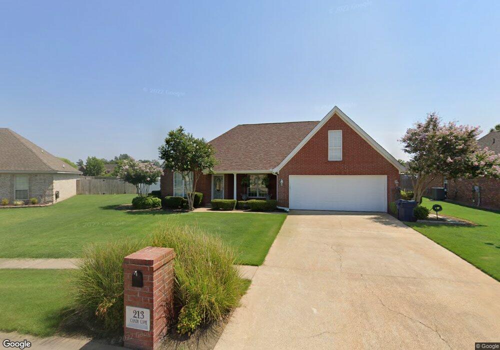
213 Candy Cove Marion, AR 72364
Estimated Value: $249,000 - $293,000
4
Beds
2
Baths
1,848
Sq Ft
$149/Sq Ft
Est. Value
About This Home
This home is located at 213 Candy Cove, Marion, AR 72364 and is currently estimated at $276,206, approximately $149 per square foot. 213 Candy Cove is a home located in Crittenden County with nearby schools including Marion Junior High School, Marion High School, and West Memphis Christian School.
Ownership History
Date
Name
Owned For
Owner Type
Purchase Details
Closed on
Aug 11, 2020
Sold by
Bethany Robert E and Beathany Sharon Ann
Bought by
Bethany Robert E and Bethany Sean Edward
Current Estimated Value
Purchase Details
Closed on
May 10, 2018
Sold by
Bethany Sean Edward
Bought by
Bethany Robert E and Bethany Sharon Ann
Purchase Details
Closed on
Apr 27, 2011
Sold by
Bethany Robert E.
Bought by
Bethany Robert E.
Purchase Details
Closed on
Dec 2, 2010
Sold by
Us Bank Na
Bought by
Bethany Robert E.
Purchase Details
Closed on
Apr 3, 2006
Sold by
Blair Donald R
Bought by
Callegari Anthony
Purchase Details
Closed on
Mar 31, 2006
Sold by
Not Provided
Bought by
Callegari Anthony
Create a Home Valuation Report for This Property
The Home Valuation Report is an in-depth analysis detailing your home's value as well as a comparison with similar homes in the area
Purchase History
| Date | Buyer | Sale Price | Title Company |
|---|---|---|---|
| Bethany Robert E | -- | None Available | |
| Bethany Robert E | -- | -- | |
| Bethany Robert E. | -- | -- | |
| Bethany Robert E. | -- | -- | |
| Callegari Anthony | -- | -- | |
| Callegari Anthony | $165,000 | -- |
Source: Public Records
Tax History
| Year | Tax Paid | Tax Assessment Tax Assessment Total Assessment is a certain percentage of the fair market value that is determined by local assessors to be the total taxable value of land and additions on the property. | Land | Improvement |
|---|---|---|---|---|
| 2025 | $1,727 | $59,817 | $6,000 | $53,817 |
| 2024 | $1,308 | $39,100 | $6,000 | $33,100 |
| 2023 | $1,382 | $39,100 | $6,000 | $33,100 |
| 2022 | $1,432 | $39,100 | $6,000 | $33,100 |
| 2021 | $1,432 | $39,100 | $6,000 | $33,100 |
| 2020 | $1,723 | $39,100 | $6,000 | $33,100 |
| 2019 | $1,569 | $30,710 | $5,200 | $25,510 |
| 2018 | $1,303 | $30,710 | $5,200 | $25,510 |
| 2017 | $1,303 | $30,710 | $5,200 | $25,510 |
| 2016 | $1,582 | $30,710 | $5,200 | $25,510 |
| 2015 | $1,316 | $30,710 | $5,200 | $25,510 |
| 2014 | $1,423 | $32,270 | $5,200 | $27,070 |
Source: Public Records
Map
Nearby Homes
- 518 Fair Oaks Cir
- 1901 State Highway 77
- 2011 State Highway 77
- 603 Oakland
- 759 Long Leaf Dr
- 381 Colonial Dr
- 107 Eveningwind Dr
- 105 Morningside Dr
- 38 Ridgeway Cove
- 470 J E Clark Cove
- 462 Dogwood Cove
- 346 Rita Rd
- 63 E Linden Ave
- 103 Stonehenge Cove
- 84 Marshall Ave
- 112 Lori Ln
- 292 Shiloh Dr
- 102 Brandywine Cove
- 694 Riverwest Cir
- 0 Canal St
- 215 Candy Cove
- 211 Candy Cove
- 232 Whispering Wind Cir
- 217 Candy Cove
- 234 Whispering Wind Cir
- 209 Candy Cove
- 206 Candy Cove
- 236 Whispering Wind Cir
- 212 Whispering Wind Cir
- 214 Whispering Wind Cir
- 219 Candy Cove
- 207 Candy Cove
- 210 Whispering Wind Cir
- 208 Candy Cove
- 238 Whispering Wind Cir
- 226 Whispering Wind Cir
- 208 Whispering Wind Cir
- 204 Candy Cove
- 205 Candy Cove
- 233 Whispering Wind Cir
Your Personal Tour Guide
Ask me questions while you tour the home.