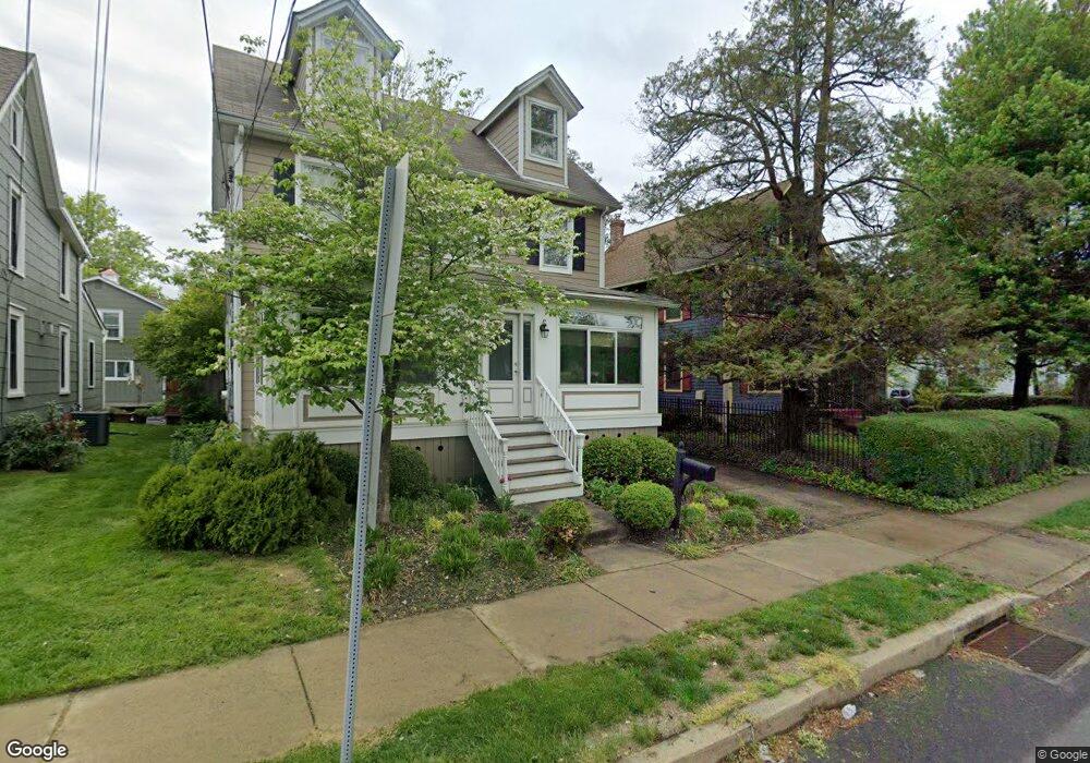
213 E Maple Ave Langhorne, PA 19047
Estimated Value: $423,514 - $522,000
4
Beds
1
Bath
1,747
Sq Ft
$273/Sq Ft
Est. Value
About This Home
This home is located at 213 E Maple Ave, Langhorne, PA 19047 and is currently estimated at $476,629, approximately $272 per square foot. 213 E Maple Ave is a home located in Bucks County with nearby schools including Tawanka Elementary School, Maple Point Middle School, and Neshaminy High School.
Ownership History
Date
Name
Owned For
Owner Type
Purchase Details
Closed on
May 8, 2017
Sold by
Potash Carey and Potash Susanne
Bought by
Potash Carey and Potash Susanne
Current Estimated Value
Home Financials for this Owner
Home Financials are based on the most recent Mortgage that was taken out on this home.
Original Mortgage
$248,500
Outstanding Balance
$204,819
Interest Rate
3.78%
Mortgage Type
New Conventional
Estimated Equity
$271,810
Purchase Details
Closed on
Apr 26, 2005
Sold by
Lee Leondus N and Lee Virginia R
Bought by
Potash Carey
Home Financials for this Owner
Home Financials are based on the most recent Mortgage that was taken out on this home.
Original Mortgage
$238,000
Interest Rate
6.05%
Mortgage Type
Purchase Money Mortgage
Purchase Details
Closed on
Apr 27, 2004
Sold by
Cendant Mobility Government Fincl Svcs C
Bought by
Lee Leondus N and Lee Virginia R
Home Financials for this Owner
Home Financials are based on the most recent Mortgage that was taken out on this home.
Original Mortgage
$229,900
Interest Rate
5.84%
Mortgage Type
Purchase Money Mortgage
Purchase Details
Closed on
Jan 12, 2004
Sold by
Sinclair Keith W and Sinclair Tracy D
Bought by
Cendant Mobility Government Fincl Svcs C
Purchase Details
Closed on
Nov 20, 2002
Sold by
Sinclair Keith W
Bought by
Sinclair Keith W and Sinclair Tracy D
Home Financials for this Owner
Home Financials are based on the most recent Mortgage that was taken out on this home.
Original Mortgage
$153,000
Interest Rate
6.17%
Purchase Details
Closed on
Jan 28, 1999
Sold by
Kaiser F David and Kaiser Sandra
Bought by
Sinclair Keith W
Home Financials for this Owner
Home Financials are based on the most recent Mortgage that was taken out on this home.
Original Mortgage
$142,500
Interest Rate
6.67%
Purchase Details
Closed on
Sep 2, 1997
Sold by
Kaiser F David and Kaiser Timothy David
Bought by
Kaiser F David and Kaiser Sandra
Purchase Details
Closed on
Aug 21, 1995
Sold by
Kaiser F David and Kaiser Lisa M
Bought by
Kaiser F David and Kaiser Timothy David
Create a Home Valuation Report for This Property
The Home Valuation Report is an in-depth analysis detailing your home's value as well as a comparison with similar homes in the area
Home Values in the Area
Average Home Value in this Area
Purchase History
| Date | Buyer | Sale Price | Title Company |
|---|---|---|---|
| Potash Carey | -- | None Available | |
| Potash Carey | $280,000 | -- | |
| Lee Leondus N | $242,000 | -- | |
| Cendant Mobility Government Fincl Svcs C | $247,500 | -- | |
| Sinclair Keith W | -- | -- | |
| Sinclair Keith W | $147,000 | T A Title Insurance Company | |
| Kaiser F David | -- | -- | |
| Kaiser F David | -- | -- |
Source: Public Records
Mortgage History
| Date | Status | Borrower | Loan Amount |
|---|---|---|---|
| Open | Potash Carey | $248,500 | |
| Closed | Potash Carey | $238,000 | |
| Previous Owner | Lee Leondus N | $229,900 | |
| Previous Owner | Sinclair Keith W | $153,000 | |
| Previous Owner | Sinclair Keith W | $142,500 |
Source: Public Records
Tax History
| Year | Tax Paid | Tax Assessment Tax Assessment Total Assessment is a certain percentage of the fair market value that is determined by local assessors to be the total taxable value of land and additions on the property. | Land | Improvement |
|---|---|---|---|---|
| 2025 | $3,884 | $17,910 | $7,720 | $10,190 |
| 2024 | $3,884 | $17,910 | $7,720 | $10,190 |
| 2023 | $3,848 | $17,910 | $7,720 | $10,190 |
| 2022 | $3,748 | $17,910 | $7,720 | $10,190 |
| 2021 | $3,748 | $17,910 | $7,720 | $10,190 |
| 2020 | $3,703 | $17,910 | $7,720 | $10,190 |
| 2019 | $3,620 | $17,910 | $7,720 | $10,190 |
| 2018 | $3,554 | $17,910 | $7,720 | $10,190 |
| 2017 | $3,404 | $17,600 | $7,720 | $9,880 |
| 2016 | $3,404 | $17,600 | $7,720 | $9,880 |
| 2015 | -- | $17,600 | $7,720 | $9,880 |
| 2014 | -- | $17,600 | $7,720 | $9,880 |
Source: Public Records
Map
Nearby Homes
- 209 N Bellevue Ave
- 138 Summit Ave
- 409 N Pine St
- 0 Highland Ave E Unit PABU2111912
- 0 Highland Ave E Unit PABU2111920
- 413 N Pine St
- 71 Golf Club Dr
- 311 Saint James Dr Unit 11
- 18 Golf Club Dr
- 1246 Saint James Dr Unit 46
- 623 Saint James Ct
- 67 Black Eyed Susan Rd
- 627 Bellflower Rd Unit V260
- 1021 W Maple Ave
- 827 Hulmeville Rd
- 866 Hulmeville Rd
- 705 Veterans Hwy
- 56 W Lincoln Hwy
- 166 N Hawthorne Ave
- 1210 Brownsville Rd
- 215 E Maple Ave
- 211 E Maple Ave
- 112 National Ave
- 210 E Maple Ave
- 118 National Ave
- 227 E Maple Ave
- 123 N Pine St
- 117 National Ave
- 121 National Ave
- 121 National Ave Unit IST FL
- 113 National Ave
- 130 National Ave
- 125 N Pine St
- 125 National Ave
- 131 N Pine St
- 129 National Ave
- 200 National Ave
- 133 N Pine St
- 152 E Maple Ave
- 182 N Pine St
Your Personal Tour Guide
Ask me questions while you tour the home.