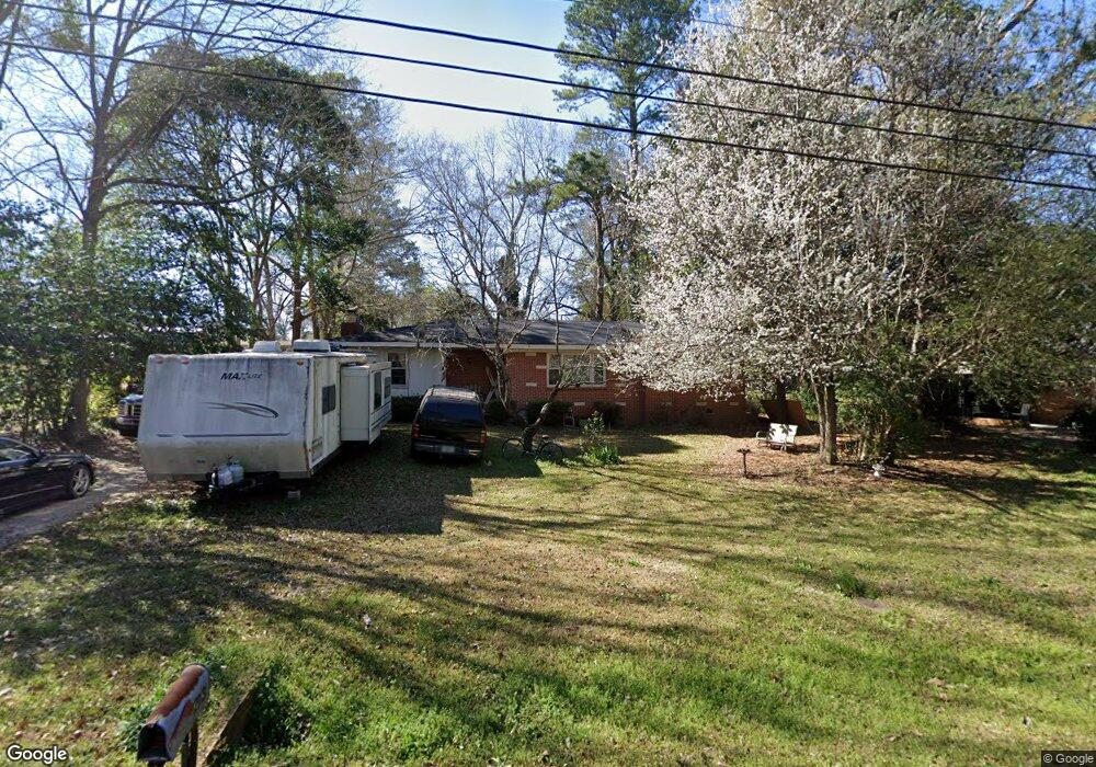
213 Knodishall Dr Warner Robins, GA 31093
Estimated Value: $148,648 - $162,000
3
Beds
2
Baths
1,452
Sq Ft
$105/Sq Ft
Est. Value
About This Home
This home is located at 213 Knodishall Dr, Warner Robins, GA 31093 and is currently estimated at $152,412, approximately $104 per square foot. 213 Knodishall Dr is a home located in Houston County with nearby schools including Westside Elementary School, Northside Middle School, and Northside High School.
Ownership History
Date
Name
Owned For
Owner Type
Purchase Details
Closed on
Sep 29, 2025
Sold by
Fogleman Todd W and Fogleman Tami R
Bought by
Burnette Michael A
Current Estimated Value
Home Financials for this Owner
Home Financials are based on the most recent Mortgage that was taken out on this home.
Original Mortgage
$71,200
Outstanding Balance
$71,200
Interest Rate
6.58%
Mortgage Type
New Conventional
Estimated Equity
$81,212
Purchase Details
Closed on
Mar 30, 2000
Sold by
Commercial Credit Plan Inc
Bought by
Fogleman Todd W and Fogleman Tami R
Purchase Details
Closed on
Jul 6, 1999
Sold by
Booth Sherrie Lynn
Bought by
Commercial Credit Plan Inc
Purchase Details
Closed on
Aug 8, 1996
Sold by
Nelson Rilla Johnson
Bought by
Booth Sherrie Lynn
Purchase Details
Closed on
May 7, 1985
Sold by
Nelson James E
Bought by
Nelson Rilla
Purchase Details
Closed on
Apr 26, 1967
Sold by
Brown Terry G
Bought by
Nelson James E
Purchase Details
Closed on
Oct 7, 1966
Sold by
Davis Walter G and Davis Bobby S
Bought by
Brown Terry G
Create a Home Valuation Report for This Property
The Home Valuation Report is an in-depth analysis detailing your home's value as well as a comparison with similar homes in the area
Home Values in the Area
Average Home Value in this Area
Purchase History
| Date | Buyer | Sale Price | Title Company |
|---|---|---|---|
| Burnette Michael A | $80,000 | None Listed On Document | |
| Fogleman Todd W | -- | -- | |
| Commercial Credit Plan Inc | -- | -- | |
| Booth Sherrie Lynn | $64,000 | -- | |
| Nelson Rilla | -- | -- | |
| Nelson James E | -- | -- | |
| Brown Terry G | -- | -- |
Source: Public Records
Mortgage History
| Date | Status | Borrower | Loan Amount |
|---|---|---|---|
| Open | Burnette Michael A | $71,200 |
Source: Public Records
Tax History Compared to Growth
Tax History
| Year | Tax Paid | Tax Assessment Tax Assessment Total Assessment is a certain percentage of the fair market value that is determined by local assessors to be the total taxable value of land and additions on the property. | Land | Improvement |
|---|---|---|---|---|
| 2024 | $1,029 | $43,000 | $6,200 | $36,800 |
| 2023 | $873 | $36,120 | $6,200 | $29,920 |
| 2022 | $761 | $31,480 | $5,000 | $26,480 |
| 2021 | $666 | $27,400 | $5,000 | $22,400 |
| 2020 | $681 | $27,880 | $5,000 | $22,880 |
| 2019 | $681 | $27,880 | $5,000 | $22,880 |
| 2018 | $681 | $27,880 | $5,000 | $22,880 |
| 2017 | $681 | $27,880 | $5,000 | $22,880 |
| 2016 | $682 | $27,880 | $5,000 | $22,880 |
| 2015 | $684 | $27,880 | $5,000 | $22,880 |
| 2014 | -- | $27,880 | $5,000 | $22,880 |
| 2013 | -- | $27,880 | $5,000 | $22,880 |
Source: Public Records
Map
Nearby Homes
- 209 Knodishall Dr
- 501 Pinecrest Dr
- 129 Maryjay Dr
- 111 Hawthorne Rd
- 110 Westcliff Cir Unit C
- 106 Westcliff Cir
- 103 Westcliff Cir Unit A
- 103 Westcliff Cir Unit A
- 112 Peacock Dr
- 221 Gilchrist Dr
- 301 Millside Dr
- 725 B East Side Dr
- 86 Westcliff Cir
- 102 Westcliff Center St Unit D
- 110 Westcliff Center St
- 303 Pinecrest Dr
- 141 Peacock Dr
- 110 Foxfire Dr
- 123 Tanglewood Dr
- 102 Williams St
- 215 Knodishall Dr
- 124 Carter Cir
- 126 Carter Cir
- 122 Carter Cir
- 217 Knodishall Dr
- 214 Knodishall Dr
- 210 Knodishall Dr
- 128 Carter Cir
- 216 Knodishall Dr
- 0 Carter Cir Unit LOT 34 OAKVIEW 139/5
- 0 Carter Cir Unit 7250382
- 0 Carter Cir Unit 8755617
- 0 Carter Cir Unit 8461102
- 0 Carter Cir Unit 8579206
- 0 Carter Cir Unit 3136723
- 38.402ac Carter Cir Unit 139
- 0 Carter Cir
- 208 Knodishall Dr
- 219 Knodishall Dr
- 207 Knodishall Dr