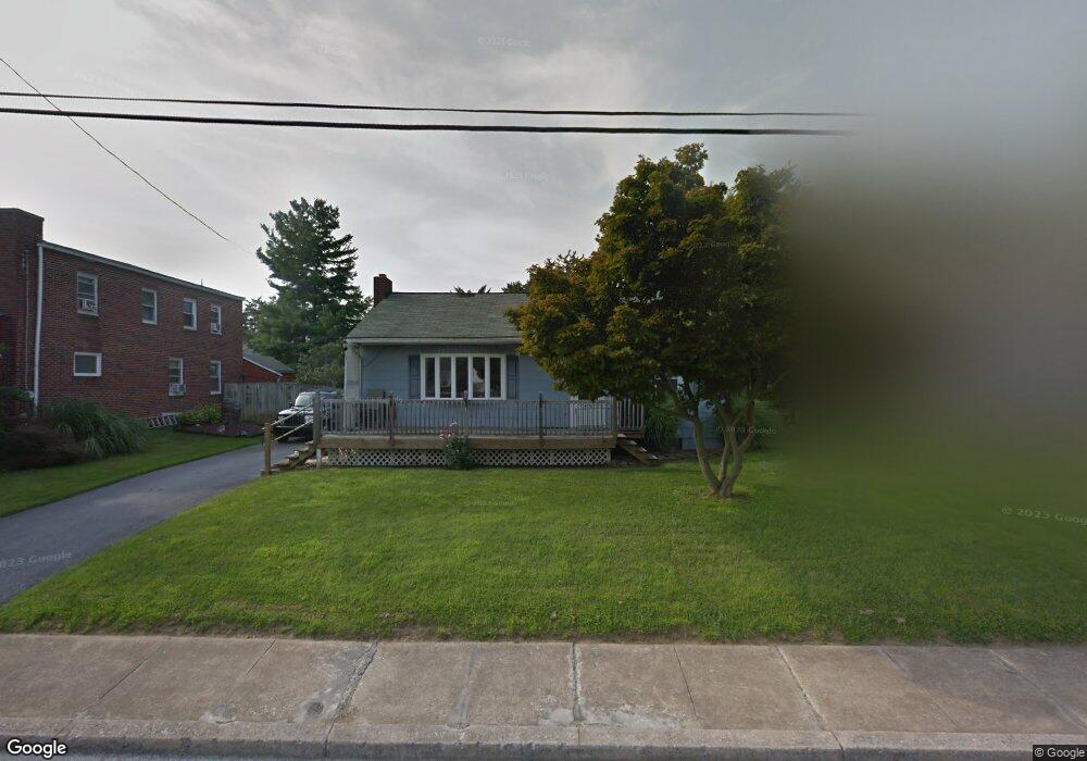
213 Locust St New Holland, PA 17557
Estimated Value: $257,000 - $308,000
3
Beds
2
Baths
960
Sq Ft
$299/Sq Ft
Est. Value
About This Home
This home is located at 213 Locust St, New Holland, PA 17557 and is currently estimated at $287,290, approximately $299 per square foot. 213 Locust St is a home located in Lancaster County with nearby schools including Garden Spot Middle School, Garden Spot Senior High School, and Mill Creek Valley Parochial School.
Ownership History
Date
Name
Owned For
Owner Type
Purchase Details
Closed on
Sep 28, 2006
Sold by
Poveda Munguia Rolando J and Poveda Ineabelle
Bought by
Bowman Richard P and Bowman Robin L
Current Estimated Value
Home Financials for this Owner
Home Financials are based on the most recent Mortgage that was taken out on this home.
Original Mortgage
$128,000
Outstanding Balance
$76,717
Interest Rate
6.54%
Mortgage Type
Purchase Money Mortgage
Estimated Equity
$210,573
Purchase Details
Closed on
Apr 27, 2005
Sold by
Miller J Mark and Miller Philip G
Bought by
Poveda Munguia Rolando J and Poveda Ineabelle
Home Financials for this Owner
Home Financials are based on the most recent Mortgage that was taken out on this home.
Original Mortgage
$111,200
Interest Rate
6.01%
Mortgage Type
Fannie Mae Freddie Mac
Create a Home Valuation Report for This Property
The Home Valuation Report is an in-depth analysis detailing your home's value as well as a comparison with similar homes in the area
Home Values in the Area
Average Home Value in this Area
Purchase History
| Date | Buyer | Sale Price | Title Company |
|---|---|---|---|
| Bowman Richard P | $168,000 | None Available | |
| Poveda Munguia Rolando J | $139,000 | -- |
Source: Public Records
Mortgage History
| Date | Status | Borrower | Loan Amount |
|---|---|---|---|
| Open | Bowman Richard P | $128,000 | |
| Previous Owner | Poveda Munguia Rolando J | $111,200 | |
| Closed | Poveda Munguia Rolando J | $20,850 |
Source: Public Records
Tax History Compared to Growth
Tax History
| Year | Tax Paid | Tax Assessment Tax Assessment Total Assessment is a certain percentage of the fair market value that is determined by local assessors to be the total taxable value of land and additions on the property. | Land | Improvement |
|---|---|---|---|---|
| 2025 | $2,551 | $127,800 | $43,000 | $84,800 |
| 2024 | $2,551 | $127,800 | $43,000 | $84,800 |
| 2023 | $2,454 | $127,800 | $43,000 | $84,800 |
| 2022 | $2,430 | $127,800 | $43,000 | $84,800 |
| 2021 | $2,330 | $127,800 | $43,000 | $84,800 |
| 2020 | $2,330 | $127,800 | $43,000 | $84,800 |
| 2019 | $2,306 | $127,800 | $43,000 | $84,800 |
| 2018 | $3,038 | $127,800 | $43,000 | $84,800 |
| 2017 | $2,140 | $96,500 | $36,100 | $60,400 |
| 2016 | $2,140 | $96,500 | $36,100 | $60,400 |
| 2015 | $689 | $96,500 | $36,100 | $60,400 |
| 2014 | $1,326 | $96,500 | $36,100 | $60,400 |
Source: Public Records
Map
Nearby Homes
- 227 Locust St
- 144 W Conestoga St
- 148 E Broad St
- 80 Diller Ave Unit 9
- 41 Ashlea Village
- 220 Sycamore Ln
- 406 Brimmer Ave
- 20 N Kinzer Ave
- 391 E Jackson St
- 385 Valley View Dr
- 753 Walnut St
- 770 (rear lot) Maple Grove Rd
- 13 Amber Cir
- 950 W Main St
- 952 W Main St
- 529 Ranck Rd Unit 1
- 529 Ranck Rd Unit 2
- 529 Ranck Rd Unit 3
- 529 Ranck Rd Unit 4
- 529 Ranck Rd Unit 5