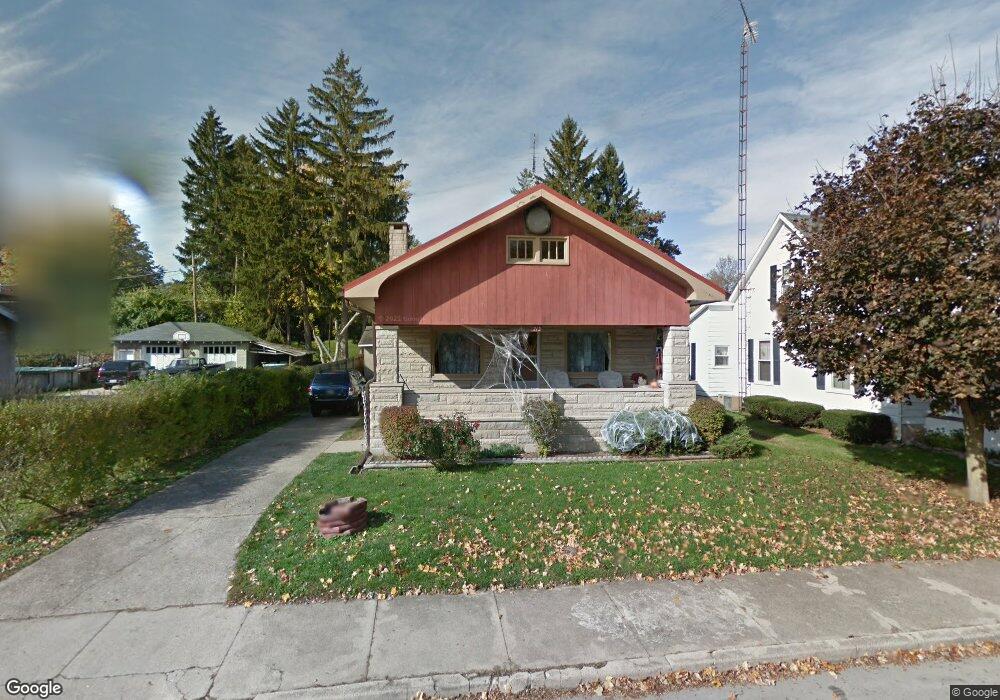
213 Mulberry St Cambridge City, IN 47327
Estimated Value: $119,000 - $148,455
2
Beds
2
Baths
1,292
Sq Ft
$108/Sq Ft
Est. Value
About This Home
This home is located at 213 Mulberry St, Cambridge City, IN 47327 and is currently estimated at $139,614, approximately $108 per square foot. 213 Mulberry St is a home located in Wayne County with nearby schools including Western Wayne Elementary School, Lincoln Middle School, and Lincoln Senior High School.
Ownership History
Date
Name
Owned For
Owner Type
Purchase Details
Closed on
Jul 31, 2024
Sold by
Dungan Edwin D and Dungan Waunalea
Bought by
Dungan Savannah M
Current Estimated Value
Purchase Details
Closed on
Apr 15, 2019
Sold by
Dungan Edwin D and Dungan Waunalea
Bought by
Dungan Sean P and Dungan Steven E
Purchase Details
Closed on
Apr 2, 2012
Sold by
Frith Jane and Limburg Johnny A
Bought by
Dungan Edwin D and Dungan Waunalea
Create a Home Valuation Report for This Property
The Home Valuation Report is an in-depth analysis detailing your home's value as well as a comparison with similar homes in the area
Home Values in the Area
Average Home Value in this Area
Purchase History
| Date | Buyer | Sale Price | Title Company |
|---|---|---|---|
| Dungan Savannah M | $74,146 | -- | |
| Dungan Sean P | -- | -- | |
| Dungan Edwin D | -- | None Available |
Source: Public Records
Mortgage History
| Date | Status | Borrower | Loan Amount |
|---|---|---|---|
| Previous Owner | Limburg John A | $15,000 |
Source: Public Records
Tax History Compared to Growth
Tax History
| Year | Tax Paid | Tax Assessment Tax Assessment Total Assessment is a certain percentage of the fair market value that is determined by local assessors to be the total taxable value of land and additions on the property. | Land | Improvement |
|---|---|---|---|---|
| 2024 | $1,202 | $109,000 | $6,200 | $102,800 |
| 2023 | $2,187 | $99,900 | $6,200 | $93,700 |
| 2022 | $2,175 | $99,300 | $6,200 | $93,100 |
| 2021 | $2,008 | $91,700 | $6,200 | $85,500 |
| 2020 | $2,008 | $91,700 | $6,200 | $85,500 |
| 2019 | $1,836 | $91,800 | $6,200 | $85,600 |
| 2018 | $1,836 | $91,800 | $6,200 | $85,600 |
| 2017 | $1,808 | $90,400 | $6,200 | $84,200 |
| 2016 | $1,696 | $84,800 | $6,200 | $78,600 |
| 2014 | $1,644 | $82,200 | $6,200 | $76,000 |
| 2013 | $1,644 | $82,400 | $6,200 | $76,200 |
Source: Public Records
Map
Nearby Homes
- 405 Mulberry St
- 228 Simmons St
- 710 W Parkway Dr
- 308 W Parkway Dr
- 208 W Front St
- 214 W Main St
- 808 National Rd
- Lot 105 Brookville Lake Resort Unit 2288 W. OLD STATE RO
- 6 Orchard St
- 37 E Church St
- 108 Orchard St
- 132 E Main St
- 102 N Pearl St
- 2212 E Cumberland Rd
- 920 E Front St
- 287 N Milton St
- 855 S State Road 1
- 54 N Center St
- 0 N Symonds Creek Rd
- 623 Queen St
- 209 Mulberry St
- 215 Mulberry St
- 518 W Parkway Dr
- 205 Mulberry St
- 218 Mulberry St
- 210 Mulberry St
- 208 Mulberry St
- 521 W Maple St
- 201 Mulberry St
- 202 Mulberry St
- 520 W Parkway Dr
- 300 Mulberry St
- 418 W Parkway Dr
- 525 W Maple St
- 419 W Maple St
- 111 Mulberry St
- 301 Hill Dr
- 435 W Parkway Dr
- 210 Hawkins Ave
- 109 Mulberry St