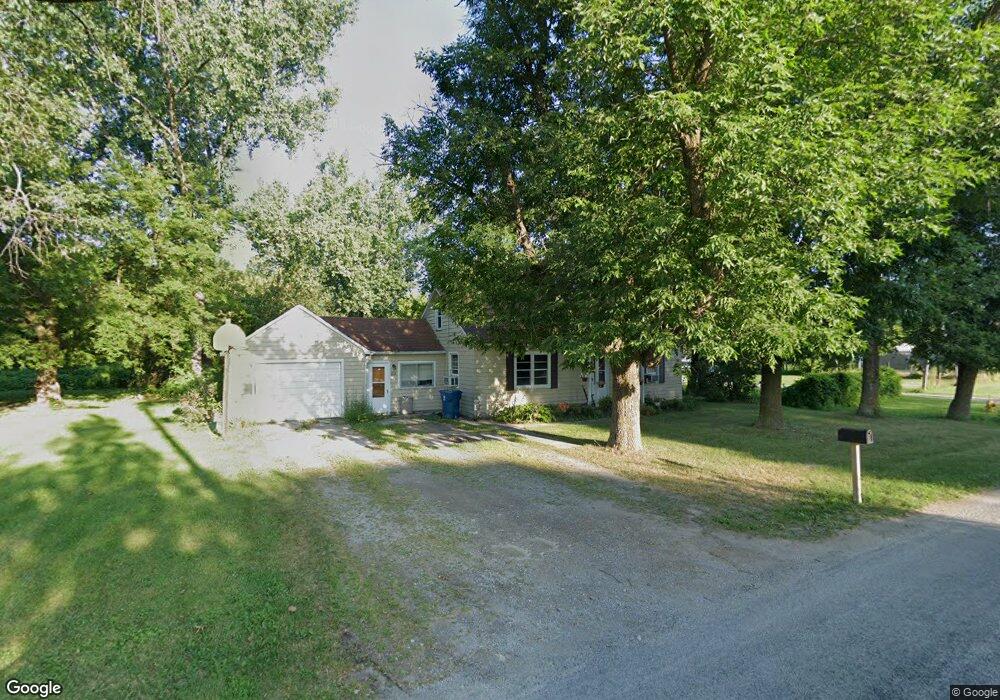
213 N Elevator Rd Linwood, MI 48634
Estimated Value: $112,088 - $146,000
1
Bed
1
Bath
1,080
Sq Ft
$116/Sq Ft
Est. Value
About This Home
This home is located at 213 N Elevator Rd, Linwood, MI 48634 and is currently estimated at $125,772, approximately $116 per square foot. 213 N Elevator Rd is a home located in Bay County with nearby schools including St Anne Elementary School.
Ownership History
Date
Name
Owned For
Owner Type
Purchase Details
Closed on
Oct 18, 2005
Sold by
Gleason Bonnie T and Gleason Lloyd P
Bought by
Yankee Steven
Current Estimated Value
Home Financials for this Owner
Home Financials are based on the most recent Mortgage that was taken out on this home.
Original Mortgage
$70,890
Outstanding Balance
$38,087
Interest Rate
5.82%
Mortgage Type
Fannie Mae Freddie Mac
Estimated Equity
$87,685
Purchase Details
Closed on
May 29, 2003
Sold by
Macdonald Edythe M and Earl Macdonald W
Bought by
Macdonald Edythe M and Macdonald Robert
Create a Home Valuation Report for This Property
The Home Valuation Report is an in-depth analysis detailing your home's value as well as a comparison with similar homes in the area
Purchase History
| Date | Buyer | Sale Price | Title Company |
|---|---|---|---|
| Yankee Steven | $65,000 | Fatic | |
| Macdonald Edythe M | -- | None Available |
Source: Public Records
Mortgage History
| Date | Status | Borrower | Loan Amount |
|---|---|---|---|
| Open | Yankee Steven | $70,890 |
Source: Public Records
Tax History
| Year | Tax Paid | Tax Assessment Tax Assessment Total Assessment is a certain percentage of the fair market value that is determined by local assessors to be the total taxable value of land and additions on the property. | Land | Improvement |
|---|---|---|---|---|
| 2025 | $343 | $47,600 | $0 | $0 |
| 2024 | $333 | $43,500 | $0 | $0 |
| 2023 | $317 | $37,600 | $0 | $0 |
| 2022 | $1,550 | $33,100 | $0 | $0 |
| 2021 | $1,109 | $30,900 | $30,900 | $0 |
| 2020 | $1,091 | $26,900 | $26,900 | $0 |
| 2019 | $1,051 | $25,100 | $0 | $0 |
| 2018 | $1,021 | $26,100 | $0 | $0 |
| 2017 | $997 | $25,600 | $0 | $0 |
| 2016 | $972 | $25,300 | $0 | $25,300 |
| 2015 | -- | $24,200 | $0 | $24,200 |
| 2014 | -- | $25,400 | $0 | $25,400 |
Source: Public Records
Map
Nearby Homes
- 1621 E Anderson Rd
- 643 S Linwood Beach Rd
- 857 N Huron Rd
- 300 S Heritier Rd
- 780 S Mackinaw Rd
- 0 N Huron Rd Unit 20250021856
- 0 Fraser Rd Unit 50195526
- 430 Ricoma Beach Rd
- 0 E River Rd
- 0 Birch Dr
- 1943 S Huron Rd
- 000 Jose Rd
- 1703 E Coggins Rd
- 0 Oak Rd Unit 50197743
- 2430 4 Mile Rd
- 2442 N Mackinaw Rd
- 2473 Old Kawkawlin Rd
- 2763 Lauria Rd
- 707 W Linwood Rd
- 661 E Beaver Rd
- 213 N Elevator Rd
- 0 N Elevator Rd
- 211 N Elevator Rd
- 210 N Elevator Rd
- 75 N Elevator Rd
- 66 N Elevator Rd
- 106 W Edwin St
- 106 W Edwin St
- 85 N Elevator Rd
- 76 N Elevator Rd
- 201 N First
- 80 N Elevator Rd
- 110 W Edwin St
- 201 N 1st St
- 115 E Center St
- 99 N Elevator Rd
- 99 N Elevator Rd
- 203 E Benjamin St
- 203 E Benjamin St
- 109 First St
Your Personal Tour Guide
Ask me questions while you tour the home.