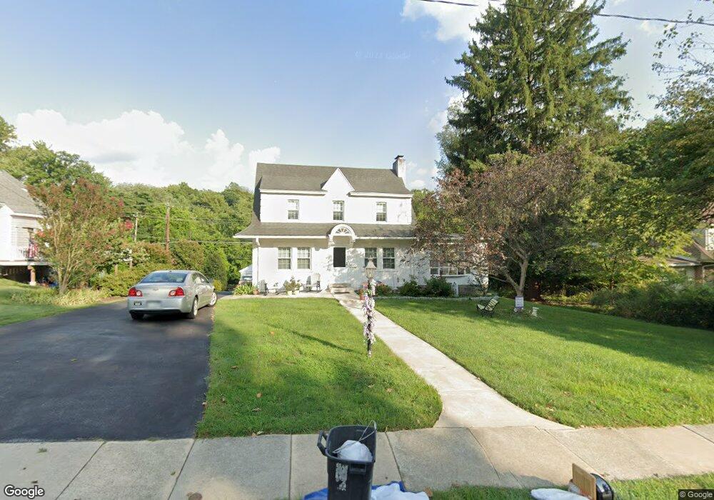
213 N Rolling Rd Springfield, PA 19064
Estimated Value: $415,000 - $501,000
3
Beds
2
Baths
1,716
Sq Ft
$278/Sq Ft
Est. Value
About This Home
This home is located at 213 N Rolling Rd, Springfield, PA 19064 and is currently estimated at $476,325, approximately $277 per square foot. 213 N Rolling Rd is a home located in Delaware County with nearby schools including Springfield High School, Vision Academy Charter School, and St Francis Of Assisi School.
Ownership History
Date
Name
Owned For
Owner Type
Purchase Details
Closed on
Aug 31, 1995
Sold by
Tabbutt David E and Singley Scott L A
Bought by
Perry Russell L and Perry Darlene M
Current Estimated Value
Home Financials for this Owner
Home Financials are based on the most recent Mortgage that was taken out on this home.
Original Mortgage
$104,000
Interest Rate
7.8%
Create a Home Valuation Report for This Property
The Home Valuation Report is an in-depth analysis detailing your home's value as well as a comparison with similar homes in the area
Home Values in the Area
Average Home Value in this Area
Purchase History
| Date | Buyer | Sale Price | Title Company |
|---|---|---|---|
| Perry Russell L | $135,000 | -- |
Source: Public Records
Mortgage History
| Date | Status | Borrower | Loan Amount |
|---|---|---|---|
| Closed | Perry Russell L | $104,000 |
Source: Public Records
Tax History
| Year | Tax Paid | Tax Assessment Tax Assessment Total Assessment is a certain percentage of the fair market value that is determined by local assessors to be the total taxable value of land and additions on the property. | Land | Improvement |
|---|---|---|---|---|
| 2025 | $8,256 | $293,740 | $122,840 | $170,900 |
| 2024 | $8,256 | $293,740 | $122,840 | $170,900 |
| 2023 | $7,950 | $293,740 | $122,840 | $170,900 |
| 2022 | $7,778 | $293,740 | $122,840 | $170,900 |
| 2021 | $12,045 | $293,740 | $122,840 | $170,900 |
| 2020 | $6,850 | $151,170 | $56,330 | $94,840 |
| 2019 | $6,689 | $151,170 | $56,330 | $94,840 |
| 2018 | $6,594 | $151,170 | $0 | $0 |
| 2017 | $6,441 | $151,170 | $0 | $0 |
| 2016 | $830 | $151,170 | $0 | $0 |
| 2015 | $847 | $151,170 | $0 | $0 |
| 2014 | $847 | $151,170 | $0 | $0 |
Source: Public Records
Map
Nearby Homes
- 220 N Rolling Rd
- 19 Wayne Ave
- 412 N Rolling Rd
- 173 Hillview Dr
- 29 School Ln
- 34 Schuyler Rd
- 120 W Springfield Rd
- 501 Flora Cir
- 472 Larchwood Rd
- 4938 State Rd
- 4928 State Rd
- 68 Pilgrim Ln
- 226 Lynbrooke Rd
- 606 W Springfield Rd
- 736 Timber Trail Ln
- 114 Pilgrim Ln
- 111 Forest Rd
- 825 Stanbridge Rd
- 173 Rambling Way
- 211 S Norwinden Dr
- 219 N Rolling Rd
- 205 N Rolling Rd
- 227 N Rolling Rd
- 201 N Rolling Rd
- 231 N Rolling Rd
- 216 N Rolling Rd
- 204 N Rolling Rd
- 155 N Rolling Rd
- 224 N Rolling Rd
- 230 N Rolling Rd
- 200 N Rolling Rd
- 149 N Rolling Rd
- 236 N Rolling Rd
- 227 N Highland Rd
- 243 N Rolling Rd
- 229 N Highland Rd
- 143 N Rolling Rd
- 115 Overhill Rd
- 242 N Rolling Rd
- 255 N Rolling Rd
Your Personal Tour Guide
Ask me questions while you tour the home.