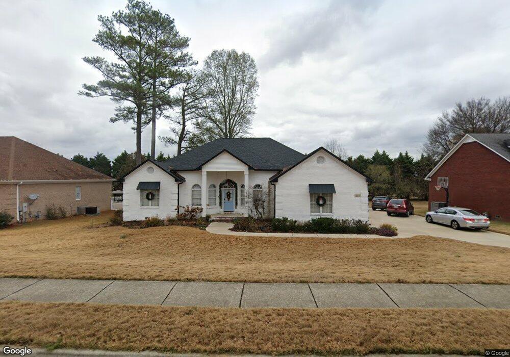
213 Pebblestone Dr Huntsville, AL 35806
Research Park NeighborhoodEstimated Value: $380,645 - $438,000
--
Bed
1
Bath
2,316
Sq Ft
$175/Sq Ft
Est. Value
About This Home
This home is located at 213 Pebblestone Dr, Huntsville, AL 35806 and is currently estimated at $406,161, approximately $175 per square foot. 213 Pebblestone Dr is a home with nearby schools including Monrovia Elementary School, Monrovia Middle School, and Sparkman High School.
Ownership History
Date
Name
Owned For
Owner Type
Purchase Details
Closed on
Aug 31, 2007
Sold by
Aycock Harold Eugene and Aycock Christy M
Bought by
Burrus Daniel Alan and Burrus Racheal M
Current Estimated Value
Home Financials for this Owner
Home Financials are based on the most recent Mortgage that was taken out on this home.
Original Mortgage
$181,500
Outstanding Balance
$30,692
Interest Rate
6.65%
Mortgage Type
New Conventional
Estimated Equity
$375,469
Create a Home Valuation Report for This Property
The Home Valuation Report is an in-depth analysis detailing your home's value as well as a comparison with similar homes in the area
Home Values in the Area
Average Home Value in this Area
Purchase History
| Date | Buyer | Sale Price | Title Company |
|---|---|---|---|
| Burrus Daniel Alan | -- | -- |
Source: Public Records
Mortgage History
| Date | Status | Borrower | Loan Amount |
|---|---|---|---|
| Open | Burrus Daniel Alan | $181,500 |
Source: Public Records
Tax History Compared to Growth
Tax History
| Year | Tax Paid | Tax Assessment Tax Assessment Total Assessment is a certain percentage of the fair market value that is determined by local assessors to be the total taxable value of land and additions on the property. | Land | Improvement |
|---|---|---|---|---|
| 2024 | $1,168 | $33,540 | $3,980 | $29,560 |
| 2023 | $1,168 | $29,160 | $3,980 | $25,180 |
| 2022 | $903 | $26,380 | $3,980 | $22,400 |
| 2021 | $903 | $26,380 | $3,980 | $22,400 |
| 2020 | $815 | $23,950 | $3,970 | $19,980 |
| 2019 | $790 | $23,270 | $3,970 | $19,300 |
| 2018 | $742 | $21,980 | $0 | $0 |
| 2017 | $742 | $21,980 | $0 | $0 |
| 2016 | $742 | $21,980 | $0 | $0 |
| 2015 | $742 | $21,980 | $0 | $0 |
| 2014 | $791 | $23,320 | $0 | $0 |
Source: Public Records
Map
Nearby Homes
- 6215 Taramore Ln NW
- 6213 Taramore Ln NW
- 6209 Taramore Ln NW
- 6219 Taramore Ln NW
- 6207 Taramore Ln NW
- 6612 Cotton Creek Rd NW
- 6032 Barringer Ct NW
- 6212 Taramore Ln NW
- 6216 Taramore Ln NW
- 6210 Taramore Ln NW
- The Sweetwater 1 Plan at Ashton Springs
- The Katelyn 1 Plan at Ashton Springs
- The Scottsdale 1 Plan at Ashton Springs
- The Wallace 1 Plan at Ashton Springs
- The Melody 1 Plan at Ashton Springs
- The Marlin 1 Plan at Ashton Springs
- 7004 Ashton Springs Blvd
- 7203 Chatfield Way NW
- 6032 Stonewater Ct NW
- 7041 Camrose Ln NW
- 215 Pebblestone Dr
- 49 Stone Mason Way NW
- 211 Pebblestone Dr
- 218 Pebblestone Dr
- 209 Pebblestone Dr
- 101 Sunstone Terrace
- 217 Pebblestone Dr
- 222 Pebblestone Dr
- 207 Pebblestone Dr
- 103 Sunstone Terrace
- 219 Pebblestone Dr
- 223 Pebblestone Dr
- 206 Pebblestone Dr
- 206 Pebble Creek Dr
- 224 Pebblestone Dr
- 105 Sunstone Terrace
- 102 Sunstone Terrace
- 205 Pebblestone Dr
- 225 Pebblestone Dr