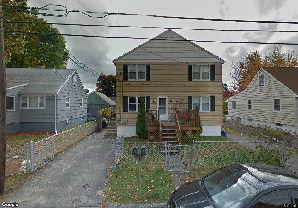
213 Roosevelt Ave Stratford, CT 06615
Stratford Center Historic District NeighborhoodEstimated Value: $379,000 - $511,000
6
Beds
2
Baths
2,040
Sq Ft
$214/Sq Ft
Est. Value
About This Home
This home is located at 213 Roosevelt Ave, Stratford, CT 06615 and is currently estimated at $435,927, approximately $213 per square foot. 213 Roosevelt Ave is a home located in Fairfield County with nearby schools including Stratford Academy - Johnson House, David Wooster Middle School, and Stratford High School.
Ownership History
Date
Name
Owned For
Owner Type
Purchase Details
Closed on
Sep 24, 2019
Sold by
Paul Joseph L and Paul Linda
Bought by
Paul Sonia A
Current Estimated Value
Home Financials for this Owner
Home Financials are based on the most recent Mortgage that was taken out on this home.
Original Mortgage
$240,000
Outstanding Balance
$210,221
Interest Rate
3.6%
Mortgage Type
Purchase Money Mortgage
Estimated Equity
$225,706
Purchase Details
Closed on
Sep 1, 1970
Bought by
Paul Joseph L and Paul Linda
Create a Home Valuation Report for This Property
The Home Valuation Report is an in-depth analysis detailing your home's value as well as a comparison with similar homes in the area
Home Values in the Area
Average Home Value in this Area
Purchase History
| Date | Buyer | Sale Price | Title Company |
|---|---|---|---|
| Paul Sonia A | $240,000 | -- | |
| Paul Joseph L | $33,000 | -- |
Source: Public Records
Mortgage History
| Date | Status | Borrower | Loan Amount |
|---|---|---|---|
| Open | Paul Sonia A | $240,000 | |
| Previous Owner | Paul Joseph L | $135,000 | |
| Previous Owner | Paul Joseph L | $69,000 |
Source: Public Records
Tax History Compared to Growth
Tax History
| Year | Tax Paid | Tax Assessment Tax Assessment Total Assessment is a certain percentage of the fair market value that is determined by local assessors to be the total taxable value of land and additions on the property. | Land | Improvement |
|---|---|---|---|---|
| 2025 | $5,285 | $131,460 | $49,070 | $82,390 |
| 2024 | $5,285 | $131,460 | $49,070 | $82,390 |
| 2023 | $5,285 | $131,460 | $49,070 | $82,390 |
| 2022 | $5,187 | $131,460 | $49,070 | $82,390 |
| 2021 | $5,189 | $131,460 | $49,070 | $82,390 |
| 2020 | $5,211 | $131,460 | $49,070 | $82,390 |
| 2019 | $5,065 | $127,050 | $40,810 | $86,240 |
| 2018 | $5,069 | $127,050 | $40,810 | $86,240 |
| 2017 | $5,078 | $127,050 | $40,810 | $86,240 |
| 2016 | $4,954 | $127,050 | $40,810 | $86,240 |
| 2015 | $4,698 | $127,050 | $40,810 | $86,240 |
| 2014 | $4,796 | $134,610 | $47,880 | $86,730 |
Source: Public Records
Map
Nearby Homes
- 216 Mckinley Ave
- 107 Dewey St
- 270 Roosevelt Ave
- 148 Columbus Ave
- 325 Mckinley Ave
- 126 Garibaldi Ave
- 66 Roosevelt Ave
- 125 Garibaldi Ave
- 208 Harding Ave
- 366 Columbus Ave
- 15 Harding Ave
- 394 Harding Ave
- 65 Masarik Ave
- 238 Larkin Ct
- 196 Avon St
- 88 Boswell St
- 79 Wooster Ave
- 209 Mcgrath Ct
- 291 Birdseye St
- 1170 South Ave
- 223 Roosevelt Ave
- 193 Roosevelt Ave
- 212 Roosevelt Ave
- 233 Roosevelt Ave
- 188 Mckinley Ave
- 183 Roosevelt Ave
- 180 Mckinley Ave
- 190 Roosevelt Ave
- 210 Mckinley Ave
- 160 Mckinley Ave
- 243 Roosevelt Ave
- 165 Roosevelt Ave
- 172 Roosevelt Ave
- 163 Roosevelt Ave
- 185 Mckinley Ave
- 75 Dewey St
- 253 Roosevelt Ave
- 93 Dewey St
- 146 Mckinley Ave
- 220 Mckinley Ave