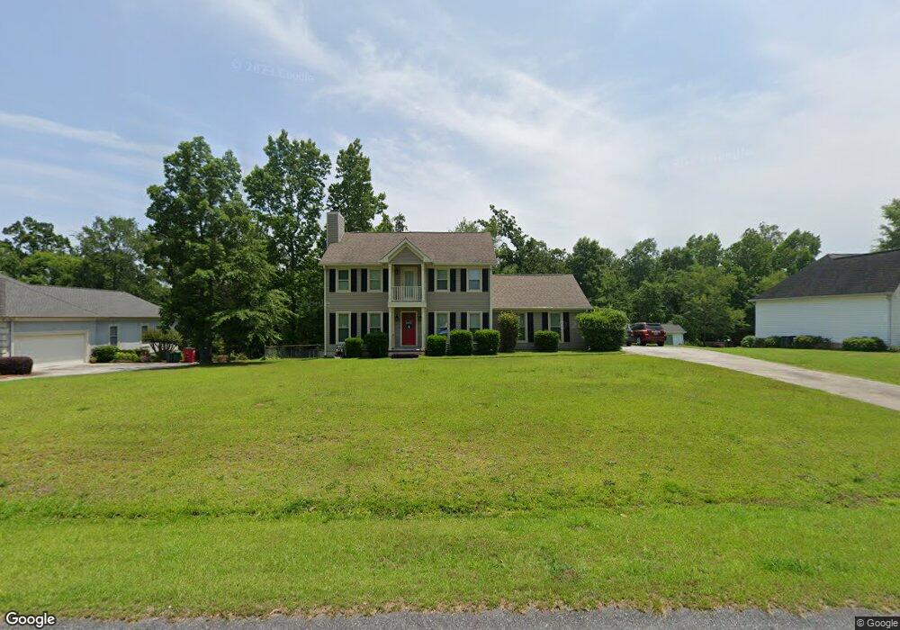
213 Saint Anthonys Dr Macon, GA 31220
Estimated Value: $259,074 - $291,000
3
Beds
3
Baths
1,952
Sq Ft
$143/Sq Ft
Est. Value
About This Home
This home is located at 213 Saint Anthonys Dr, Macon, GA 31220 and is currently estimated at $278,269, approximately $142 per square foot. 213 Saint Anthonys Dr is a home located in Bibb County with nearby schools including Heritage Elementary School, Weaver Middle School, and Westside High School.
Ownership History
Date
Name
Owned For
Owner Type
Purchase Details
Closed on
May 31, 2006
Sold by
Lindsey Bobby Steven and Lindsey Mary Katherine
Bought by
Sikes John R and Sikes Misti Mosely
Current Estimated Value
Home Financials for this Owner
Home Financials are based on the most recent Mortgage that was taken out on this home.
Original Mortgage
$153,939
Outstanding Balance
$88,871
Interest Rate
6.44%
Mortgage Type
FHA
Estimated Equity
$189,398
Create a Home Valuation Report for This Property
The Home Valuation Report is an in-depth analysis detailing your home's value as well as a comparison with similar homes in the area
Home Values in the Area
Average Home Value in this Area
Purchase History
| Date | Buyer | Sale Price | Title Company |
|---|---|---|---|
| Sikes John R | $158,700 | None Avilebel |
Source: Public Records
Mortgage History
| Date | Status | Borrower | Loan Amount |
|---|---|---|---|
| Open | Sikes John R | $153,939 |
Source: Public Records
Tax History Compared to Growth
Tax History
| Year | Tax Paid | Tax Assessment Tax Assessment Total Assessment is a certain percentage of the fair market value that is determined by local assessors to be the total taxable value of land and additions on the property. | Land | Improvement |
|---|---|---|---|---|
| 2025 | $1,650 | $74,154 | $10,000 | $64,154 |
| 2024 | $1,706 | $74,154 | $10,000 | $64,154 |
| 2023 | $1,248 | $74,154 | $10,000 | $64,154 |
| 2022 | $1,728 | $56,906 | $10,800 | $46,106 |
| 2021 | $1,896 | $56,906 | $10,800 | $46,106 |
| 2020 | $1,965 | $57,620 | $10,800 | $46,820 |
| 2019 | $1,982 | $57,620 | $10,800 | $46,820 |
| 2018 | $3,215 | $57,620 | $10,800 | $46,820 |
| 2017 | $1,897 | $57,620 | $10,800 | $46,820 |
| 2016 | $1,751 | $57,620 | $10,800 | $46,820 |
| 2015 | $2,479 | $57,620 | $10,800 | $46,820 |
| 2014 | $2,483 | $57,620 | $10,800 | $46,820 |
Source: Public Records
Map
Nearby Homes
- 119 Cordell Ct
- 6671 Moseley Dixon Rd
- 6806 Bay Point Dr
- 1905 Johnson Rd
- 123 Harbor Dr
- 141 Harbor Dr
- 147 Harbor Dr
- 159 Harbor Dr
- 153 Harbor Dr
- 165 Harbor Dr
- 221 Shoreline Way
- 116 Nautica Point
- 213 Shoreline Way Unit LOT A018
- 209 Shoreline Way
- Plan 3629 at Treetops
- Plan 2100 at Treetops
- Plan 2307 at Treetops
- Plan 2628 at Treetops
- Plan 2316 at Treetops
- Plan 2700 at Treetops
- 211 Saint Anthonys Dr
- 215 Saint Anthonys Dr
- 118 Cordell Ct
- 0 Saint Anthonys Dr
- 217 St Anthony''S Dr
- 217 St Anthonys Dr
- 217 Saint Anthonys Dr
- 214 St Anthonys Dr
- 214 Saint Anthonys Dr
- 120 Cordell Ct
- 209 Saint Anthonys Dr
- 209 Saint Anthonys Dr Unit 17
- 216 Saint Anthonys Dr
- 212 Saint Anthonys Dr
- 116 Cordell Ct
- 205 Saint Anthonys Dr
- 218 Saint Anthonys Dr
- 210 Saint Anthonys Dr
- 219 Saint Anthonys Dr
- 6584 Dana Dr