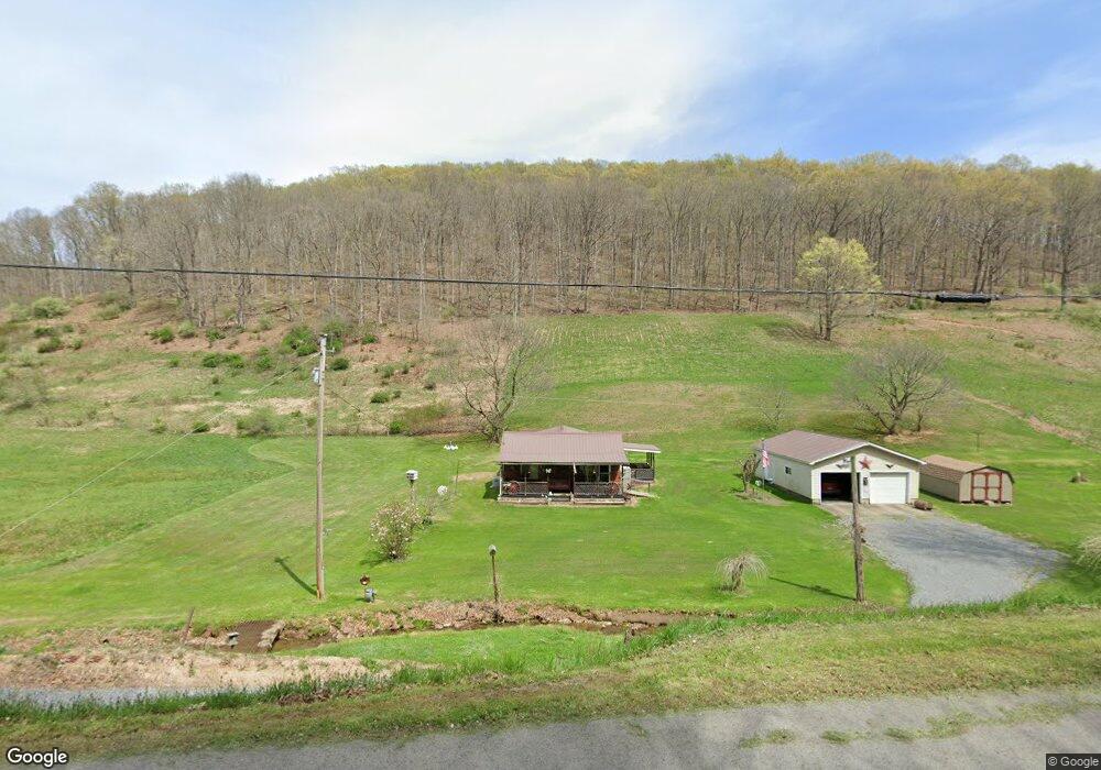
213 Saint Leo Rd Wadestown, WV 26590
Estimated Value: $150,000 - $252,000
3
Beds
2
Baths
1,764
Sq Ft
$105/Sq Ft
Est. Value
About This Home
This home is located at 213 Saint Leo Rd, Wadestown, WV 26590 and is currently estimated at $186,000, approximately $105 per square foot. 213 Saint Leo Rd is a home with nearby schools including Mason-Dixon Elementary School and Clay-Battelle Middle/High School.
Ownership History
Date
Name
Owned For
Owner Type
Purchase Details
Closed on
Jul 8, 2025
Sold by
Copeland Sondra L
Bought by
Duc Hunter Llc
Current Estimated Value
Purchase Details
Closed on
Jul 7, 2025
Sold by
Hayes Kelly A and Hayes Kelley
Bought by
Duc Hunter Llc
Purchase Details
Closed on
Nov 23, 2020
Sold by
Tennant Donna and Hockenberry John Richard
Bought by
Six Forrest Hunter
Purchase Details
Closed on
Jun 9, 2017
Sold by
Norheast Natural Energy Llc
Bought by
Hockenberry Delores Jean
Create a Home Valuation Report for This Property
The Home Valuation Report is an in-depth analysis detailing your home's value as well as a comparison with similar homes in the area
Home Values in the Area
Average Home Value in this Area
Purchase History
| Date | Buyer | Sale Price | Title Company |
|---|---|---|---|
| Duc Hunter Llc | $425 | None Listed On Document | |
| Duc Hunter Llc | $425 | None Listed On Document | |
| Duc Hunter Llc | $521 | None Listed On Document | |
| Duc Hunter Llc | $521 | None Listed On Document | |
| Six Forrest Hunter | $125,000 | None Available | |
| Hockenberry Delores Jean | -- | None Available | |
| Hockenberry Delores Jean | -- | None Available |
Source: Public Records
Tax History Compared to Growth
Tax History
| Year | Tax Paid | Tax Assessment Tax Assessment Total Assessment is a certain percentage of the fair market value that is determined by local assessors to be the total taxable value of land and additions on the property. | Land | Improvement |
|---|---|---|---|---|
| 2024 | $720 | $67,420 | $20,680 | $46,740 |
| 2023 | $718 | $67,430 | $20,690 | $46,740 |
| 2022 | $679 | $66,290 | $20,450 | $45,840 |
| 2021 | $477 | $66,290 | $20,450 | $45,840 |
| 2020 | $479 | $66,300 | $20,460 | $45,840 |
| 2019 | $479 | $65,990 | $20,450 | $45,540 |
| 2018 | $481 | $65,990 | $20,450 | $45,540 |
| 2017 | $483 | $65,960 | $20,420 | $45,540 |
| 2016 | $492 | $66,480 | $20,340 | $46,140 |
| 2015 | $470 | $66,510 | $20,340 | $46,170 |
| 2014 | $435 | $65,070 | $19,500 | $45,570 |
Source: Public Records
Map
Nearby Homes
- 53 Saint Leo Rd
- 1931 Saint Leo Rd
- 8541 Mason Dixon Hwy
- TBD White Creek
- 832 Church Fork Rd
- 24 and 24.1 Pyles Fork Rd
- 13 Church Fork Rd
- 1742 Rush Run Rd
- 808 Rush Run Rd
- 104 Renner Creek Rd
- 135 Oak Forest Rd
- 1125 Toms Run Rd
- 119 Blockhouse Rd
- 223 Dudley Fork Rd
- 106 Carnegie Ln
- 4506 Daybrook Rd
- 417 Main St
- TBD Daybrook Rd
- 128 Main St
- 1985 Browns Run Rd
- 170 Saint Leo Rd
- 181 Saint Leo Rd
- 136 Saint Leo Rd
- 85 Saint Leo Rd
- 127 Saint Leo Rd
- 53 Saint Leo Rd
- 15 Saint Leo Rd
- 9841 Mason Dixon Hwy
- 42 Wadestown Rd
- 16 Wadestown Rd
- 10 Wadestown Rd
- 10 Wadestown Rd
- 1 Range Rd
- 11 Wadestown Rd
- 17 Wadestown Rd
- 9894 Mason-Dixon Hwy
- 357 Saint Leo Rd
- 9826 Mason Dixon Hwy
- 29 Wadestown Loop Rd
- 110 Wadestown Rd