Estimated Value: $197,000 - $227,000
--
Bed
2
Baths
1,700
Sq Ft
$122/Sq Ft
Est. Value
About This Home
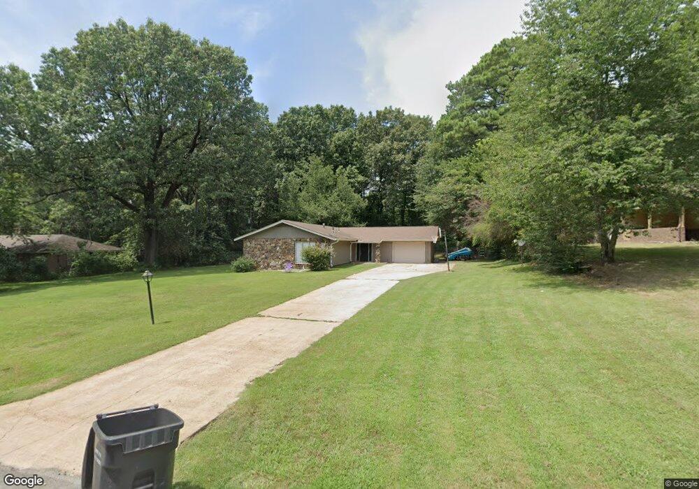
This home is located at 213 Shady Ln, Bono, AR 72416 and is currently estimated at $207,502, approximately $122 per square foot. 213 Shady Ln is a home located in Craighead County with nearby schools including Westside Elementary School, Westside Middle School, and Westside High School.
Ownership History
Date
Name
Owned For
Owner Type
Purchase Details
Closed on
Jun 7, 2018
Sold by
Macdonlad Cathy E
Bought by
Cline Brad and Cline Suzanne
Current Estimated Value
Purchase Details
Closed on
Dec 2, 2009
Sold by
Macdonald Cathy E Hunter and Macdonald Cathey E Hunter
Bought by
Macdonald Cathy E
Home Financials for this Owner
Home Financials are based on the most recent Mortgage that was taken out on this home.
Original Mortgage
$39,200
Interest Rate
4.46%
Mortgage Type
New Conventional
Purchase Details
Closed on
May 23, 2006
Sold by
Hunter Robert M
Bought by
Hunter Cathey E
Purchase Details
Closed on
Aug 27, 1999
Bought by
Macdonald
Purchase Details
Closed on
May 23, 1995
Bought by
Caples
Create a Home Valuation Report for This Property
The Home Valuation Report is an in-depth analysis detailing your home's value as well as a comparison with similar homes in the area
Home Values in the Area
Average Home Value in this Area
Purchase History
| Date | Buyer | Sale Price | Title Company |
|---|---|---|---|
| Cline Brad | $85,000 | None Available | |
| Macdonald Cathy E | -- | None Available | |
| Hunter Cathey E | -- | None Available | |
| Macdonald | $68,000 | -- | |
| Caples | $72,000 | -- |
Source: Public Records
Mortgage History
| Date | Status | Borrower | Loan Amount |
|---|---|---|---|
| Previous Owner | Macdonald Cathy E | $39,200 |
Source: Public Records
Tax History Compared to Growth
Tax History
| Year | Tax Paid | Tax Assessment Tax Assessment Total Assessment is a certain percentage of the fair market value that is determined by local assessors to be the total taxable value of land and additions on the property. | Land | Improvement |
|---|---|---|---|---|
| 2025 | $1,233 | $29,283 | $4,000 | $25,283 |
| 2024 | $1,233 | $29,283 | $4,000 | $25,283 |
| 2023 | $1,112 | $29,283 | $4,000 | $25,283 |
| 2022 | $1,020 | $29,283 | $4,000 | $25,283 |
| 2021 | $948 | $21,300 | $4,000 | $17,300 |
| 2020 | $948 | $21,300 | $4,000 | $17,300 |
| 2019 | $948 | $21,300 | $4,000 | $17,300 |
| 2018 | $597 | $21,300 | $4,000 | $17,300 |
| 2017 | $553 | $21,300 | $4,000 | $17,300 |
| 2016 | $510 | $19,320 | $2,400 | $16,920 |
| 2015 | $860 | $19,320 | $2,400 | $16,920 |
| 2014 | $510 | $19,320 | $2,400 | $16,920 |
Source: Public Records
Map
Nearby Homes
- 945 County Road 111
- 219 Maurita St
- 20 Acres Parker Rd and I-555
- 67.78 acres Cr 114
- 581 County Road 130
- 1284 County Road 114
- 727 Cr 311
- 14 County Road 346
- 97 County Road 130
- 279 County Road 342
- 1 County Road 342
- 3-Acres Damron Dr
- 1 Strawfloor Dr
- 18.62 acres Strawfloor Dr
- 0 Strawfloor Dr
- 393 County Road 371
- 1 County Road 348
- 2572 Highway 349
- 2713 W Matthews Ave
- 2064 Sloan Lake Dr