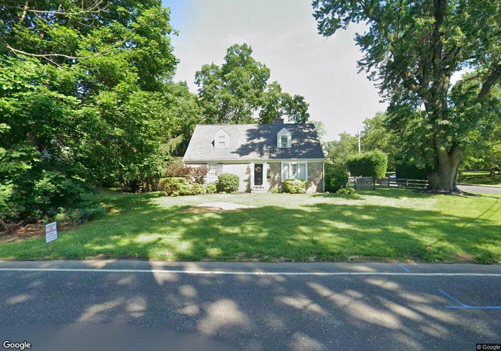
213 Twining Rd Oreland, PA 19075
Estimated Value: $537,596 - $587,000
4
Beds
2
Baths
1,988
Sq Ft
$281/Sq Ft
Est. Value
About This Home
This home is located at 213 Twining Rd, Oreland, PA 19075 and is currently estimated at $558,399, approximately $280 per square foot. 213 Twining Rd is a home located in Montgomery County with nearby schools including Jarrettown Elementary School, Sandy Run Middle School, and Upper Dublin High School.
Ownership History
Date
Name
Owned For
Owner Type
Purchase Details
Closed on
Apr 29, 2009
Sold by
Desoo Beth S and Desoo Thomas R
Bought by
Murray Jennifer L and Murray Nicholas A
Current Estimated Value
Home Financials for this Owner
Home Financials are based on the most recent Mortgage that was taken out on this home.
Original Mortgage
$289,656
Outstanding Balance
$183,011
Interest Rate
4.85%
Estimated Equity
$375,388
Purchase Details
Closed on
Sep 25, 1998
Sold by
Thompson T Louise
Bought by
Desoo Thomas R and Desoo Beth S
Create a Home Valuation Report for This Property
The Home Valuation Report is an in-depth analysis detailing your home's value as well as a comparison with similar homes in the area
Home Values in the Area
Average Home Value in this Area
Purchase History
| Date | Buyer | Sale Price | Title Company |
|---|---|---|---|
| Murray Jennifer L | $295,000 | None Available | |
| Desoo Thomas R | $150,000 | -- |
Source: Public Records
Mortgage History
| Date | Status | Borrower | Loan Amount |
|---|---|---|---|
| Open | Murray Jennifer L | $289,656 |
Source: Public Records
Tax History Compared to Growth
Tax History
| Year | Tax Paid | Tax Assessment Tax Assessment Total Assessment is a certain percentage of the fair market value that is determined by local assessors to be the total taxable value of land and additions on the property. | Land | Improvement |
|---|---|---|---|---|
| 2025 | $6,556 | $134,440 | $59,760 | $74,680 |
| 2024 | $6,556 | $134,440 | $59,760 | $74,680 |
| 2023 | $6,403 | $134,440 | $59,760 | $74,680 |
| 2022 | $6,263 | $134,440 | $59,760 | $74,680 |
| 2021 | $6,107 | $134,440 | $59,760 | $74,680 |
| 2020 | $5,931 | $134,440 | $59,760 | $74,680 |
| 2019 | $5,832 | $134,440 | $59,760 | $74,680 |
| 2018 | $5,831 | $134,440 | $59,760 | $74,680 |
| 2017 | $5,619 | $134,440 | $59,760 | $74,680 |
| 2016 | $5,567 | $134,440 | $59,760 | $74,680 |
| 2015 | $5,258 | $134,440 | $59,760 | $74,680 |
| 2014 | $5,258 | $134,440 | $59,760 | $74,680 |
Source: Public Records
Map
Nearby Homes
- 101 Orlando Ave
- 118 Twining Rd
- 122 Garden Rd
- 314 Girard Ave
- 332 Logan Ave
- 140 Linden Ave
- 120 Linden Ave
- 222 Ruscombe Ave
- 501 Martin Ln
- 238 Plymouth Ave
- 221 Central Ave
- 550 Penn Ave
- 342 Cricket Ave
- 25 Northview Dr
- 502 Central Ave
- 623 Penn Ave
- 616 Tennis Ave
- 541 Cardinal Dr
- 441 Cricket Ave
- 536 Cardinal Dr