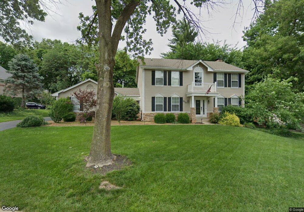
213 White Pine Ct Saint Charles, MO 63304
Estimated Value: $460,849 - $508,000
4
Beds
3
Baths
2,448
Sq Ft
$197/Sq Ft
Est. Value
About This Home
This home is located at 213 White Pine Ct, Saint Charles, MO 63304 and is currently estimated at $481,962, approximately $196 per square foot. 213 White Pine Ct is a home located in St. Charles County with nearby schools including Warren Elementary School, Saeger Middle School, and Francis Howell Central High School.
Ownership History
Date
Name
Owned For
Owner Type
Purchase Details
Closed on
Sep 12, 2019
Sold by
Lundergan Stephen M and Lundergan Linda C
Bought by
Alexander Darrell W and Alexander Lauren M
Current Estimated Value
Home Financials for this Owner
Home Financials are based on the most recent Mortgage that was taken out on this home.
Original Mortgage
$337,250
Outstanding Balance
$296,008
Interest Rate
3.7%
Mortgage Type
New Conventional
Estimated Equity
$185,954
Create a Home Valuation Report for This Property
The Home Valuation Report is an in-depth analysis detailing your home's value as well as a comparison with similar homes in the area
Home Values in the Area
Average Home Value in this Area
Purchase History
| Date | Buyer | Sale Price | Title Company |
|---|---|---|---|
| Alexander Darrell W | -- | Select Title Group |
Source: Public Records
Mortgage History
| Date | Status | Borrower | Loan Amount |
|---|---|---|---|
| Open | Alexander Darrell W | $337,250 |
Source: Public Records
Tax History Compared to Growth
Tax History
| Year | Tax Paid | Tax Assessment Tax Assessment Total Assessment is a certain percentage of the fair market value that is determined by local assessors to be the total taxable value of land and additions on the property. | Land | Improvement |
|---|---|---|---|---|
| 2025 | $4,106 | $74,426 | -- | -- |
| 2023 | $4,104 | $68,783 | $0 | $0 |
| 2022 | $3,635 | $56,565 | $0 | $0 |
| 2021 | $3,639 | $56,565 | $0 | $0 |
| 2020 | $3,605 | $54,247 | $0 | $0 |
| 2019 | $3,589 | $54,247 | $0 | $0 |
| 2018 | $3,395 | $49,043 | $0 | $0 |
| 2017 | $3,367 | $49,043 | $0 | $0 |
| 2016 | $2,958 | $41,453 | $0 | $0 |
| 2015 | $2,924 | $41,453 | $0 | $0 |
| 2014 | $2,746 | $37,764 | $0 | $0 |
Source: Public Records
Map
Nearby Homes
- 6024 Mo-N Unit Lot 2
- 6025 Mo-N Unit Lot 1
- 1622 Piedmont Cir Unit 5C
- 201 Valley Lakes Ct
- 507 Roth Ct
- 25 Terre Verte Ct
- 301 Switchgrass Landing Ln
- Rosemont Plan at Prairie Bluff - Heritage Collection
- Sierra Plan at Prairie Bluff - Heritage Collection
- Sierra – Universal Design Plan at Prairie Bluff - Heritage Collection
- Pierce Plan at Prairie Bluff - Heritage Collection
- Lancaster Plan at Prairie Bluff - Heritage Collection
- Chesapeake Plan at Prairie Bluff - Heritage Collection
- Windsor Plan at Prairie Bluff - Heritage Collection
- Bridgeport Plan at Prairie Bluff - Heritage Collection
- Davenport Plan at Prairie Bluff - Heritage Collection
- Portsmouth Plan at Prairie Bluff - Heritage Collection
- Braxton Plan at Prairie Bluff - Heritage Collection
- 102 Deer Meadow Ct
- 0 Universal Design Prairie Bluff Unit MAR24041208
- 217 White Pine Ct
- 209 White Pine Ct
- 222 Lazy Ridge Dr
- 226 Lazy Ridge Dr
- 204 White Pine Ct
- 205 White Pine Ct
- 208 White Pine Ct
- 212 White Pine Ct
- 218 Lazy Ridge Dr
- 230 Lazy Ridge Dr
- 216 White Pine Ct
- 225 White Pine Ct
- 360 Mason Ridge Dr
- 201 White Pine Ct
- 214 Lazy Ridge Dr
- 368 Mason Ridge Dr
- 234 Lazy Ridge Dr
- 356 Mason Ridge Dr
- 220 White Pine Ct
- 100 Iron Lake Ct