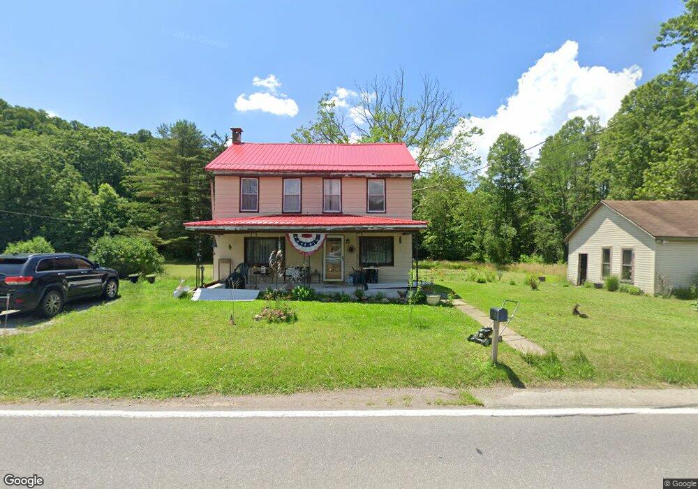
2131 Listonburg Rd Confluence, PA 15424
Estimated Value: $119,000 - $230,000
3
Beds
2
Baths
1,560
Sq Ft
$105/Sq Ft
Est. Value
About This Home
This home is located at 2131 Listonburg Rd, Confluence, PA 15424 and is currently estimated at $163,736, approximately $104 per square foot. 2131 Listonburg Rd is a home located in Somerset County with nearby schools including Turkeyfoot Valley Area Elementary School and Turkeyfoot Valley Area Junior/Senior High School.
Ownership History
Date
Name
Owned For
Owner Type
Purchase Details
Closed on
Nov 8, 2019
Sold by
Knox John R and Knox Mona Y
Bought by
Adams Theda I
Current Estimated Value
Purchase Details
Closed on
Mar 15, 2007
Sold by
Wells Fargo Bank Na
Bought by
Option One Mortgage Corp
Home Financials for this Owner
Home Financials are based on the most recent Mortgage that was taken out on this home.
Original Mortgage
$45,000
Interest Rate
7%
Mortgage Type
Assumption
Purchase Details
Closed on
Mar 13, 2007
Sold by
Option One Mortgage Corp
Bought by
Knox John R and Knox Mona Y
Home Financials for this Owner
Home Financials are based on the most recent Mortgage that was taken out on this home.
Original Mortgage
$45,000
Interest Rate
7%
Mortgage Type
Assumption
Create a Home Valuation Report for This Property
The Home Valuation Report is an in-depth analysis detailing your home's value as well as a comparison with similar homes in the area
Home Values in the Area
Average Home Value in this Area
Purchase History
| Date | Buyer | Sale Price | Title Company |
|---|---|---|---|
| Adams Theda I | $87,500 | None Available | |
| Option One Mortgage Corp | $42,753 | None Available | |
| Knox John R | $42,753 | None Available |
Source: Public Records
Mortgage History
| Date | Status | Borrower | Loan Amount |
|---|---|---|---|
| Previous Owner | Knox John R | $45,000 |
Source: Public Records
Tax History
| Year | Tax Paid | Tax Assessment Tax Assessment Total Assessment is a certain percentage of the fair market value that is determined by local assessors to be the total taxable value of land and additions on the property. | Land | Improvement |
|---|---|---|---|---|
| 2025 | $1,095 | $23,410 | $0 | $0 |
| 2024 | $1,095 | $23,410 | $0 | $0 |
| 2023 | $1,054 | $23,410 | $0 | $0 |
| 2022 | $1,027 | $23,410 | $0 | $0 |
| 2021 | $1,003 | $23,410 | $0 | $0 |
| 2020 | $1,003 | $23,410 | $0 | $0 |
| 2019 | $1,003 | $23,410 | $0 | $0 |
| 2018 | $993 | $23,410 | $6,750 | $16,660 |
| 2017 | $993 | $23,410 | $6,750 | $16,660 |
| 2016 | -- | $24,100 | $7,420 | $16,680 |
| 2015 | -- | $24,100 | $7,420 | $16,680 |
| 2014 | -- | $24,100 | $7,420 | $16,680 |
Source: Public Records
Map
Nearby Homes
- 0 Listenburg Rd
- Lot 6 Klondike Rd
- Lot 2 Klondike Rd
- Lot 1 Klondike Rd
- 0 Klondike Rd Unit 22177073
- 0 Klondike Rd Unit 22177082
- 0 Klondike Rd Unit 22177074
- 0 Listonburg Rd Unit 11682627
- 842 Anderson St
- 734 Main St
- 104 Groff Rd
- 891 Main St
- 833 Oden St
- 147 Fike Ln
- 631 Meyers St
- 000
- 626 Sterner St
- 159 Cedar Rd
- 629 River Rd
- #5 & 7 Laurel Rd
- 2126 Listonburg Rd
- 2851 Fort Hill Rd
- 119 Camp Ground Rd
- 2092 Listonburg Rd
- 2092 Listonburg Rd
- 2839 Fort Hill Rd
- 2823 Fort Hill Rd
- 2804 Fort Hill Rd
- 2051 Listonburg Rd
- 2051 Listonburg Rd
- 2206 Listonburg Rd
- 149 Camp Ground Rd
- 2758 Fort Hill Rd
- 2036 Listonburg Rd
- 2756 Fort Hill Rd
- 2227 Listonburg Rd
- 2004 Listonburg Rd
- 106 Camp Ground Rd
- 141 Camp Ground Rd
- 2253 Listonburg Rd
Your Personal Tour Guide
Ask me questions while you tour the home.