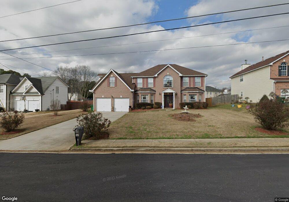
2134 Eagles Nest Cir Decatur, GA 30035
Southwest DeKalb NeighborhoodEstimated Value: $336,658 - $413,000
4
Beds
3
Baths
2,979
Sq Ft
$121/Sq Ft
Est. Value
About This Home
This home is located at 2134 Eagles Nest Cir, Decatur, GA 30035 and is currently estimated at $361,915, approximately $121 per square foot. 2134 Eagles Nest Cir is a home located in DeKalb County with nearby schools including Canby Lane Elementary School, Mary McLeod Bethune Middle School, and Towers High School.
Ownership History
Date
Name
Owned For
Owner Type
Purchase Details
Closed on
Aug 16, 2010
Sold by
Gamble Eugene
Bought by
Gamble Eugene and Gamble Martha
Current Estimated Value
Purchase Details
Closed on
Sep 19, 2002
Sold by
Madison Dev Holding Inc
Bought by
Gamble Eugene
Home Financials for this Owner
Home Financials are based on the most recent Mortgage that was taken out on this home.
Original Mortgage
$176,806
Interest Rate
6.19%
Mortgage Type
FHA
Create a Home Valuation Report for This Property
The Home Valuation Report is an in-depth analysis detailing your home's value as well as a comparison with similar homes in the area
Home Values in the Area
Average Home Value in this Area
Purchase History
| Date | Buyer | Sale Price | Title Company |
|---|---|---|---|
| Gamble Eugene | -- | -- | |
| Gamble Eugene | $179,600 | -- |
Source: Public Records
Mortgage History
| Date | Status | Borrower | Loan Amount |
|---|---|---|---|
| Previous Owner | Gamble Eugene | $176,806 |
Source: Public Records
Tax History Compared to Growth
Tax History
| Year | Tax Paid | Tax Assessment Tax Assessment Total Assessment is a certain percentage of the fair market value that is determined by local assessors to be the total taxable value of land and additions on the property. | Land | Improvement |
|---|---|---|---|---|
| 2025 | $4,304 | $133,000 | $16,000 | $117,000 |
| 2024 | $4,393 | $128,400 | $16,000 | $112,400 |
| 2023 | $4,393 | $130,040 | $16,000 | $114,040 |
| 2022 | $3,821 | $112,440 | $10,000 | $102,440 |
| 2021 | $3,121 | $92,120 | $10,000 | $82,120 |
| 2020 | $2,762 | $81,520 | $10,000 | $71,520 |
| 2019 | $2,577 | $77,000 | $10,000 | $67,000 |
| 2018 | $2,128 | $68,320 | $10,000 | $58,320 |
| 2017 | $2,364 | $68,320 | $8,320 | $60,000 |
| 2016 | $2,256 | $66,880 | $8,320 | $58,560 |
| 2014 | $1,351 | $40,760 | $8,320 | $32,440 |
Source: Public Records
Map
Nearby Homes
- 4579 Tudor Castle Dr
- 2065 Resting Creek Dr
- 2428 Marsh Rabbit Bend
- 5181 Covington Hwy
- 5169 Covington Hwy
- 5159 Covington Hwy
- 4421 John Wesley Dr
- 4827 Snap Creek Ln
- 4373 Buckingham Cir
- 5160 Covington Hwy Unit 18
- 5160 Covington Hwy
- 4612 Grand Central Pkwy
- 1830 Broadway St
- 2360 S Hairston Rd
- 2087 John Wesley Ct
- 5094 Covington Hwy
- 2014 Manhattan Pkwy
- 4371 Aldergate Dr
- 4379 Cross Ln
- 2183 Ramblewood Cir
- 2138 Eagles Nest Cir
- 2338 Eagles Nest Cir
- 4657 Seagull Cove
- 4663 Seagull Cove
- 2142 Eagles Nest Cir
- 2328 Eagles Nest Cir
- 2133 Eagles Nest Cir
- 2341 Eagles Nest Cir
- 2320 Eagles Nest Cir
- 2150 Eagles Nest Cir
- 2137 Eagles Nest Cir
- 2337 Eagles Nest Cir
- 4668 Seagull Cove
- 2141 Eagles Nest Cir
- 2260 Quail Forest Ct
- 2154 Eagles Nest Cir
- 2312 Eagles Nest Cir
- 4658 Seagull Cove
- 2145 Eagles Nest Cir
- 2323 Eagles Nest Cir