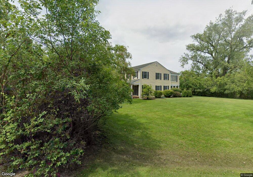
2134 Middlefork Rd Northfield, IL 60093
Estimated Value: $1,514,738 - $1,945,000
5
Beds
4
Baths
3,997
Sq Ft
$457/Sq Ft
Est. Value
About This Home
This home is located at 2134 Middlefork Rd, Northfield, IL 60093 and is currently estimated at $1,828,435, approximately $457 per square foot. 2134 Middlefork Rd is a home located in Cook County with nearby schools including Middlefork Primary School, Sunset Ridge Elementary School, and New Trier Township High School - Northfield.
Ownership History
Date
Name
Owned For
Owner Type
Purchase Details
Closed on
Nov 25, 2024
Sold by
Marital Trust and Thomas W Reedy Trust
Bought by
Reedy Catherine B
Current Estimated Value
Purchase Details
Closed on
May 3, 2019
Sold by
Reedy Thomas W and Reedy Catherine B
Bought by
Thomas W Reedy Trust
Create a Home Valuation Report for This Property
The Home Valuation Report is an in-depth analysis detailing your home's value as well as a comparison with similar homes in the area
Home Values in the Area
Average Home Value in this Area
Purchase History
| Date | Buyer | Sale Price | Title Company |
|---|---|---|---|
| Reedy Catherine B | -- | None Listed On Document | |
| Catherine B Reedy Trust | -- | None Listed On Document | |
| Marital Trust | -- | None Listed On Document | |
| Thomas W Reedy Trust | -- | Attorney |
Source: Public Records
Tax History
| Year | Tax Paid | Tax Assessment Tax Assessment Total Assessment is a certain percentage of the fair market value that is determined by local assessors to be the total taxable value of land and additions on the property. | Land | Improvement |
|---|---|---|---|---|
| 2025 | $23,823 | $142,000 | $53,317 | $88,683 |
| 2024 | $23,823 | $116,337 | $44,431 | $71,906 |
| 2023 | $22,553 | $116,337 | $44,431 | $71,906 |
| 2022 | $22,553 | $116,337 | $44,431 | $71,906 |
| 2021 | $18,407 | $81,900 | $31,101 | $50,799 |
| 2020 | $18,091 | $81,900 | $31,101 | $50,799 |
| 2019 | $17,783 | $90,000 | $31,101 | $58,899 |
| 2018 | $18,143 | $87,500 | $39,987 | $47,513 |
| 2017 | $17,598 | $87,500 | $39,987 | $47,513 |
| 2016 | $17,842 | $87,500 | $39,987 | $47,513 |
| 2015 | $19,414 | $90,975 | $22,215 | $68,760 |
| 2014 | $19,056 | $90,975 | $22,215 | $68,760 |
| 2013 | $18,235 | $90,975 | $22,215 | $68,760 |
Source: Public Records
Map
Nearby Homes
- 2122 Middlefork Rd
- 590 Briar Ln
- 898 Bridlegate Ln
- 1990 Southridge Terrace
- 2154 Northgate Rd
- 513 Edens Ln
- 1930 Sunset Ridge Rd
- 405 Voltz Rd
- 265 Dickens St
- 831 Balmoral Ln
- 164 Wagner Rd
- 308 Happ Rd Unit 201
- 220 Sunset Ridge Rd
- 2700 Summit Dr Unit 101
- 985 Pine Tree Ln
- 947 Kensington Dr Unit 7E3
- 118 Dickens Rd
- 2033 Winnetka Rd
- 1900 Winnetka Ave
- 1492 Asbury Ave
- 2132 Middlefork Rd
- 2106 Middlefork Rd
- 2131 Middlefork Rd
- 2094 Middlefork Rd
- 2129 Middlefork Rd
- 2108 Middlefork Rd
- 2130 Middlefork Rd
- 2117 Middlefork Rd
- 2062 Suffork Rd
- 2080 Norfork Rd
- 2067 Norfork Rd
- 2110 Middlefork Rd
- 655 Briar Ln
- 2121 Middlefork Rd
- 2081 Norfork Rd
- 2126 Middlefork Rd
- 2066 Middlefork Rd
- 2112 Middlefork Rd
- 2124 Middlefork Rd
- 2116 Middlefork Rd
Your Personal Tour Guide
Ask me questions while you tour the home.