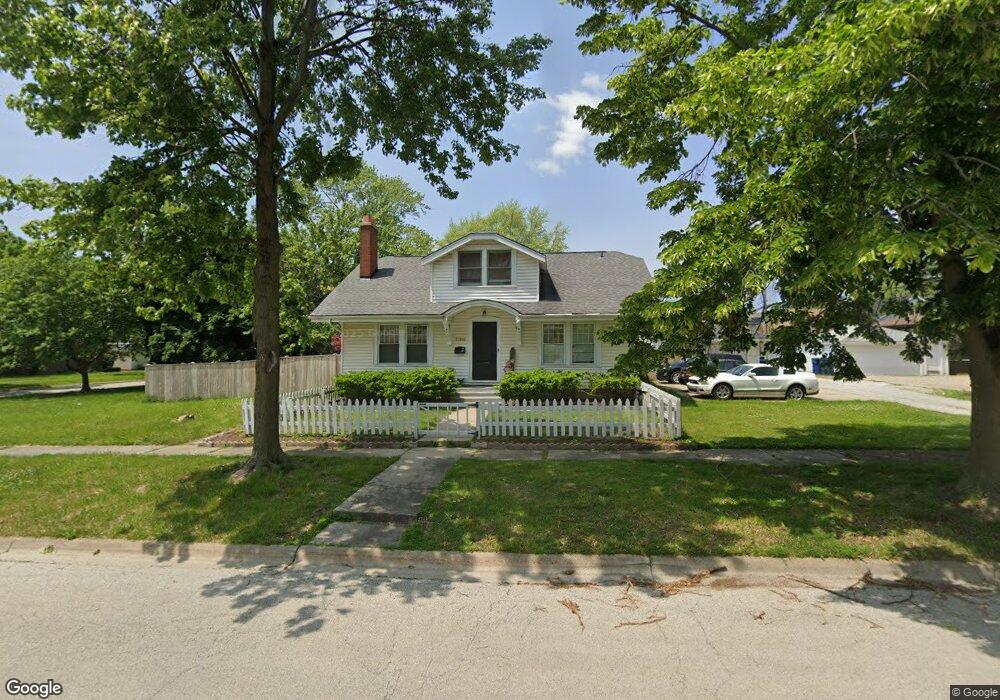
21350 Locust St Matteson, IL 60443
Old Matteson NeighborhoodEstimated Value: $199,000 - $238,553
4
Beds
2
Baths
2,040
Sq Ft
$107/Sq Ft
Est. Value
About This Home
This home is located at 21350 Locust St, Matteson, IL 60443 and is currently estimated at $217,638, approximately $106 per square foot. 21350 Locust St is a home located in Cook County with nearby schools including Illinois School, Matteson Elementary School, and Sauk Elementary School.
Ownership History
Date
Name
Owned For
Owner Type
Purchase Details
Closed on
Mar 2, 2023
Sold by
Storm Patrick A and Storm Lora D
Bought by
Johnson Mark
Current Estimated Value
Home Financials for this Owner
Home Financials are based on the most recent Mortgage that was taken out on this home.
Original Mortgage
$134,250
Interest Rate
7.63%
Mortgage Type
New Conventional
Create a Home Valuation Report for This Property
The Home Valuation Report is an in-depth analysis detailing your home's value as well as a comparison with similar homes in the area
Home Values in the Area
Average Home Value in this Area
Purchase History
| Date | Buyer | Sale Price | Title Company |
|---|---|---|---|
| Johnson Mark | $179,000 | None Listed On Document |
Source: Public Records
Mortgage History
| Date | Status | Borrower | Loan Amount |
|---|---|---|---|
| Previous Owner | Johnson Mark | $134,250 |
Source: Public Records
Tax History
| Year | Tax Paid | Tax Assessment Tax Assessment Total Assessment is a certain percentage of the fair market value that is determined by local assessors to be the total taxable value of land and additions on the property. | Land | Improvement |
|---|---|---|---|---|
| 2025 | $5,706 | $16,788 | $2,640 | $14,148 |
| 2024 | $5,706 | $16,788 | $2,640 | $14,148 |
| 2023 | $3,497 | $16,788 | $2,640 | $14,148 |
| 2022 | $3,497 | $9,526 | $2,310 | $7,216 |
| 2021 | $3,590 | $9,525 | $2,310 | $7,215 |
| 2020 | $3,429 | $9,525 | $2,310 | $7,215 |
| 2019 | $4,470 | $11,724 | $2,145 | $9,579 |
| 2018 | $4,467 | $11,724 | $2,145 | $9,579 |
| 2017 | $4,315 | $11,724 | $2,145 | $9,579 |
| 2016 | $3,466 | $9,297 | $1,980 | $7,317 |
| 2015 | $3,381 | $9,297 | $1,980 | $7,317 |
| 2014 | $3,298 | $9,297 | $1,980 | $7,317 |
| 2013 | $3,298 | $10,007 | $1,980 | $8,027 |
Source: Public Records
Map
Nearby Homes
- 3615 214th St
- 3727 214th Place Unit 2
- 3704 215th St Unit 205
- 21308 Tower Ave
- 3624 216th St
- 21142 Locust St
- 3919 214th St
- 21406 S Jean Ave
- 3719 211th Place
- 3421 Station Dr
- 21602 Dogwood Rd Unit 1184
- 4022 Richmond Ct
- 21617 Dogwood Rd Unit 1125
- 21635 Dogwood Rd Unit 1165
- 21616 Richmond Rd
- 126 Indiana St
- 888 Woodstock Rd
- 338 Waldmann Dr
- 3704 Linden Rd
- 3435 218th Place
- 21350 Locust St
- 3716 214th St
- 3720 214th St
- 3707 213th Place
- 21349 Locust St
- 21349 Locust St
- 3715 213th Place
- 3707 214th St
- 3724 214th St
- 3719 213th Place
- 3715 214th St
- 21335 Locust St
- 3719 214th St
- 3728 214th St
- 3723 213th Place
- 3631 213th Place
- 21409 Locust St
- 21409 Locust St
- 3723 214th St
- 3727 213th Place
Your Personal Tour Guide
Ask me questions while you tour the home.