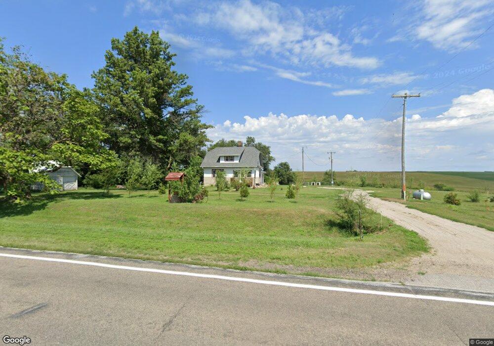
2136 Highway 32 West Point, NE 68788
Estimated Value: $313,000 - $348,000
3
Beds
2
Baths
1,376
Sq Ft
$243/Sq Ft
Est. Value
About This Home
This home is located at 2136 Highway 32, West Point, NE 68788 and is currently estimated at $334,541, approximately $243 per square foot. 2136 Highway 32 is a home located in Cuming County with nearby schools including West Point-Beemer Junior/Senior High School.
Ownership History
Date
Name
Owned For
Owner Type
Purchase Details
Closed on
Jun 4, 2020
Sold by
Otte Timothy M and Otte Elsa S
Bought by
Carper Jon E and Carper Lori L
Current Estimated Value
Home Financials for this Owner
Home Financials are based on the most recent Mortgage that was taken out on this home.
Original Mortgage
$164,000
Outstanding Balance
$144,729
Interest Rate
3.2%
Mortgage Type
Future Advance Clause Open End Mortgage
Estimated Equity
$189,812
Purchase Details
Closed on
May 1, 2018
Sold by
Otte Marietta J and Otte Merlin D
Bought by
T & E Ag Llc
Home Financials for this Owner
Home Financials are based on the most recent Mortgage that was taken out on this home.
Original Mortgage
$2,570,000
Interest Rate
4.45%
Mortgage Type
Construction
Purchase Details
Closed on
Sep 26, 2017
Sold by
Otte Timothy M and Otte Elsa S
Bought by
Otte Timothy M and Otte Elsa S
Home Financials for this Owner
Home Financials are based on the most recent Mortgage that was taken out on this home.
Original Mortgage
$105,000
Interest Rate
3.89%
Mortgage Type
New Conventional
Create a Home Valuation Report for This Property
The Home Valuation Report is an in-depth analysis detailing your home's value as well as a comparison with similar homes in the area
Home Values in the Area
Average Home Value in this Area
Purchase History
| Date | Buyer | Sale Price | Title Company |
|---|---|---|---|
| Carper Jon E | $205,000 | Charter T&E Svcs Inc | |
| T & E Ag Llc | $130,000 | None Available | |
| Otte Timothy M | -- | None Available |
Source: Public Records
Mortgage History
| Date | Status | Borrower | Loan Amount |
|---|---|---|---|
| Open | Carper Jon E | $164,000 | |
| Previous Owner | T & E Ag Llc | $2,570,000 | |
| Previous Owner | Otte Timothy M | $105,000 |
Source: Public Records
Tax History Compared to Growth
Tax History
| Year | Tax Paid | Tax Assessment Tax Assessment Total Assessment is a certain percentage of the fair market value that is determined by local assessors to be the total taxable value of land and additions on the property. | Land | Improvement |
|---|---|---|---|---|
| 2025 | $1,434 | $262,010 | $48,930 | $213,080 |
| 2024 | $1,434 | $235,535 | $48,585 | $186,950 |
| 2023 | $2,032 | $224,690 | $45,470 | $179,220 |
| 2022 | $1,868 | $188,670 | $32,660 | $156,010 |
| 2021 | $1,656 | $165,455 | $32,970 | $132,485 |
| 2020 | $1,365 | $138,315 | $32,970 | $105,345 |
| 2019 | $1,284 | $127,620 | $32,970 | $94,650 |
| 2018 | $1,292 | $130,145 | $35,470 | $94,675 |
| 2017 | $1,161 | $112,805 | $23,920 | $88,885 |
| 2016 | $993 | $92,765 | $23,920 | $68,845 |
| 2015 | $870 | $74,445 | $21,995 | $52,450 |
| 2014 | $1,345 | $69,895 | $19,985 | $49,910 |
| 2013 | $1,345 | $96,410 | $47,510 | $48,900 |
Source: Public Records
Map
Nearby Homes
- 2416 F Rd
- 1225 Co Road 1
- 1045 E Grove St
- 126 E Grove St
- 2235 K Rd
- 749 E Grove St
- 420 S Farragut St
- 626 S Monitor St
- 1402 E Bridge St
- 519 S Niphon St
- 205 E Sheridan St
- 208 N Lincoln St
- 101 S Main St
- 301 W Pine St
- 1207 N Main St
- 402 W Pine St
- TBD Oakland
- 328 N Oakland Ave
- 108 N Thomas Ave
- 206 N Thomas Ave