Estimated Value: $120,000 - $166,000
1
Bed
1
Bath
1,276
Sq Ft
$115/Sq Ft
Est. Value
About This Home
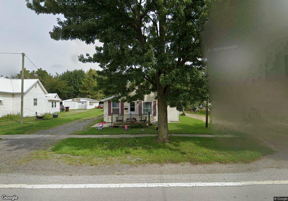
This home is located at 214 E North Ave, Ada, OH 45810 and is currently estimated at $146,722, approximately $114 per square foot. 214 E North Ave is a home located in Hardin County with nearby schools including Ada Elementary School and Ada High School.
Ownership History
Date
Name
Owned For
Owner Type
Purchase Details
Closed on
Aug 27, 2020
Sold by
Golden Michael A
Bought by
Sexton James
Current Estimated Value
Purchase Details
Closed on
Jul 7, 2017
Sold by
Sizemore Jay
Bought by
Golden Michael A
Purchase Details
Closed on
Feb 15, 2008
Sold by
Us Bank Ank
Bought by
Jr Jay Sizemore
Purchase Details
Closed on
Apr 7, 2005
Sold by
Lawrence Linda
Bought by
Hershberger Robert S
Home Financials for this Owner
Home Financials are based on the most recent Mortgage that was taken out on this home.
Original Mortgage
$55,000
Interest Rate
9.81%
Mortgage Type
Adjustable Rate Mortgage/ARM
Purchase Details
Closed on
Sep 10, 2004
Bought by
Lawrence Linda
Purchase Details
Closed on
Jul 28, 1997
Bought by
Marling Wilbur L
Purchase Details
Closed on
Jan 20, 1989
Create a Home Valuation Report for This Property
The Home Valuation Report is an in-depth analysis detailing your home's value as well as a comparison with similar homes in the area
Home Values in the Area
Average Home Value in this Area
Purchase History
| Date | Buyer | Sale Price | Title Company |
|---|---|---|---|
| Sexton James | $95,000 | None Available | |
| Golden Michael A | $49,000 | None Available | |
| Jr Jay Sizemore | $8,600 | None Available | |
| Hershberger Robert S | $55,000 | -- | |
| Lawrence Linda | -- | -- | |
| Marling Wilbur L | -- | -- | |
| -- | $18,000 | -- |
Source: Public Records
Mortgage History
| Date | Status | Borrower | Loan Amount |
|---|---|---|---|
| Previous Owner | Hershberger Robert S | $55,000 |
Source: Public Records
Tax History
| Year | Tax Paid | Tax Assessment Tax Assessment Total Assessment is a certain percentage of the fair market value that is determined by local assessors to be the total taxable value of land and additions on the property. | Land | Improvement |
|---|---|---|---|---|
| 2024 | $996 | $35,050 | $2,730 | $32,320 |
| 2023 | $1,387 | $35,050 | $2,730 | $32,320 |
| 2022 | $1,202 | $26,370 | $2,650 | $23,720 |
| 2021 | $1,321 | $26,370 | $2,650 | $23,720 |
| 2020 | $1,338 | $26,370 | $2,650 | $23,720 |
| 2019 | $1,203 | $23,930 | $2,520 | $21,410 |
| 2018 | $1,177 | $23,930 | $2,520 | $21,410 |
| 2017 | $1,069 | $23,930 | $2,520 | $21,410 |
| 2016 | $933 | $20,290 | $2,440 | $17,850 |
| 2015 | $886 | $20,290 | $2,440 | $17,850 |
| 2014 | $911 | $20,290 | $2,440 | $17,850 |
| 2013 | $1,007 | $21,350 | $2,440 | $18,910 |
Source: Public Records
Map
Nearby Homes
- 530 N Main St
- 629 N Main St
- 724 N Main St
- 442 Edwards St
- 503 E North Ave
- 746 N Main St Unit 61
- 746 N Main St Unit 63
- 746 N Main St Unit 74
- 746 N Main St Unit 9
- 746 N Main St Unit 35
- 746 N Main St Unit 5
- 746 N Main St Unit 39
- 128 W North Ave
- 327 W North Ave
- 211 S Main St
- 210 N Gilbert St
- 308-310 S Simon St
- 602 Conley Ave
- 314 E University Ave
- 710 S Main St
- 208 E North Ave
- 214 E North St
- 211 North St E
- 218 E North Ave
- 202 E North Ave
- 203 E North Ave
- 211 E North Ave
- 222 E North Ave
- 222 E North Ave
- 620 N Johnson St
- 621 N Johnson St
- 568 N Johnson St
- 228 E North Ave
- 569 N Johnson St
- 539 N Simon St
- 205 Franklin St
- 607 N Simon St
- 535 N Simon St
- 538 N Johnson St
- 205 Franklin Ave
Your Personal Tour Guide
Ask me questions while you tour the home.