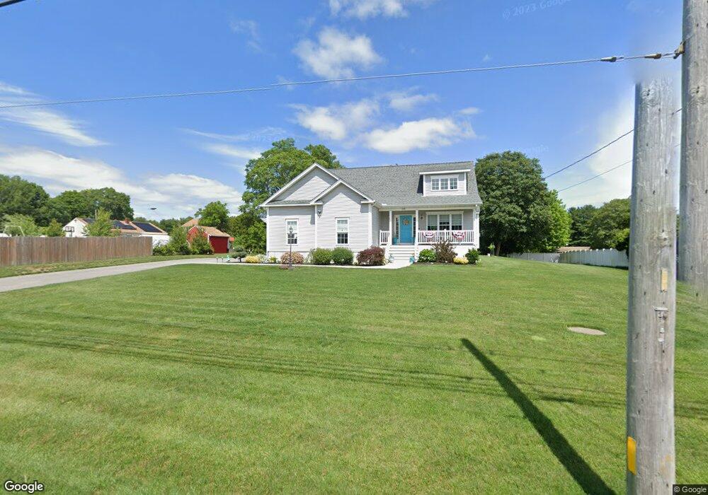
214 Gifford Rd Westport, MA 02790
North Westport NeighborhoodEstimated Value: $659,000 - $815,000
3
Beds
3
Baths
2,224
Sq Ft
$326/Sq Ft
Est. Value
About This Home
This home is located at 214 Gifford Rd, Westport, MA 02790 and is currently estimated at $725,555, approximately $326 per square foot. 214 Gifford Rd is a home with nearby schools including Alice A. Macomber Primary School, Westport Elementary School, and Westport Middle-High School.
Ownership History
Date
Name
Owned For
Owner Type
Purchase Details
Closed on
Oct 1, 2024
Sold by
Alves Jose M and Alves Olga M
Bought by
214 Gifford Rd Rt and Alves
Current Estimated Value
Purchase Details
Closed on
Oct 19, 2017
Sold by
Pavao Norberta M and Pavao James S
Bought by
Alves Jose M and Alves Olga
Purchase Details
Closed on
Jul 18, 1994
Sold by
Cadieux Joanne
Bought by
Pavao James S and Pavao Norberta M
Purchase Details
Closed on
Aug 31, 1992
Sold by
Cadieux Michael N
Bought by
Cadieux Joanne
Home Financials for this Owner
Home Financials are based on the most recent Mortgage that was taken out on this home.
Original Mortgage
$51,149
Interest Rate
8.09%
Mortgage Type
Purchase Money Mortgage
Create a Home Valuation Report for This Property
The Home Valuation Report is an in-depth analysis detailing your home's value as well as a comparison with similar homes in the area
Home Values in the Area
Average Home Value in this Area
Purchase History
| Date | Buyer | Sale Price | Title Company |
|---|---|---|---|
| 214 Gifford Rd Rt | -- | None Available | |
| 214 Gifford Rd Rt | -- | None Available | |
| Alves Jose M | $130,000 | -- | |
| Pavao James S | $95,000 | -- | |
| Cadieux Joanne | $4,100 | -- | |
| Pavao James S | $95,000 | -- | |
| Cadieux Joanne | $4,100 | -- |
Source: Public Records
Mortgage History
| Date | Status | Borrower | Loan Amount |
|---|---|---|---|
| Previous Owner | Cadieux Joanne | $51,149 | |
| Previous Owner | Cadieux Joanne | $51,000 |
Source: Public Records
Tax History Compared to Growth
Tax History
| Year | Tax Paid | Tax Assessment Tax Assessment Total Assessment is a certain percentage of the fair market value that is determined by local assessors to be the total taxable value of land and additions on the property. | Land | Improvement |
|---|---|---|---|---|
| 2025 | $4,924 | $660,900 | $173,600 | $487,300 |
| 2024 | $4,881 | $631,400 | $154,200 | $477,200 |
| 2023 | $4,773 | $584,900 | $140,400 | $444,500 |
| 2022 | $4,399 | $518,700 | $140,400 | $378,300 |
| 2021 | $4,262 | $494,400 | $116,100 | $378,300 |
| 2020 | $4,626 | $548,800 | $111,400 | $437,400 |
| 2019 | $921 | $111,400 | $111,400 | $0 |
| 2018 | $918 | $112,400 | $112,400 | $0 |
| 2017 | $867 | $108,800 | $108,800 | $0 |
| 2016 | $832 | $105,200 | $105,200 | $0 |
| 2015 | $853 | $107,600 | $107,600 | $0 |
Source: Public Records
Map
Nearby Homes