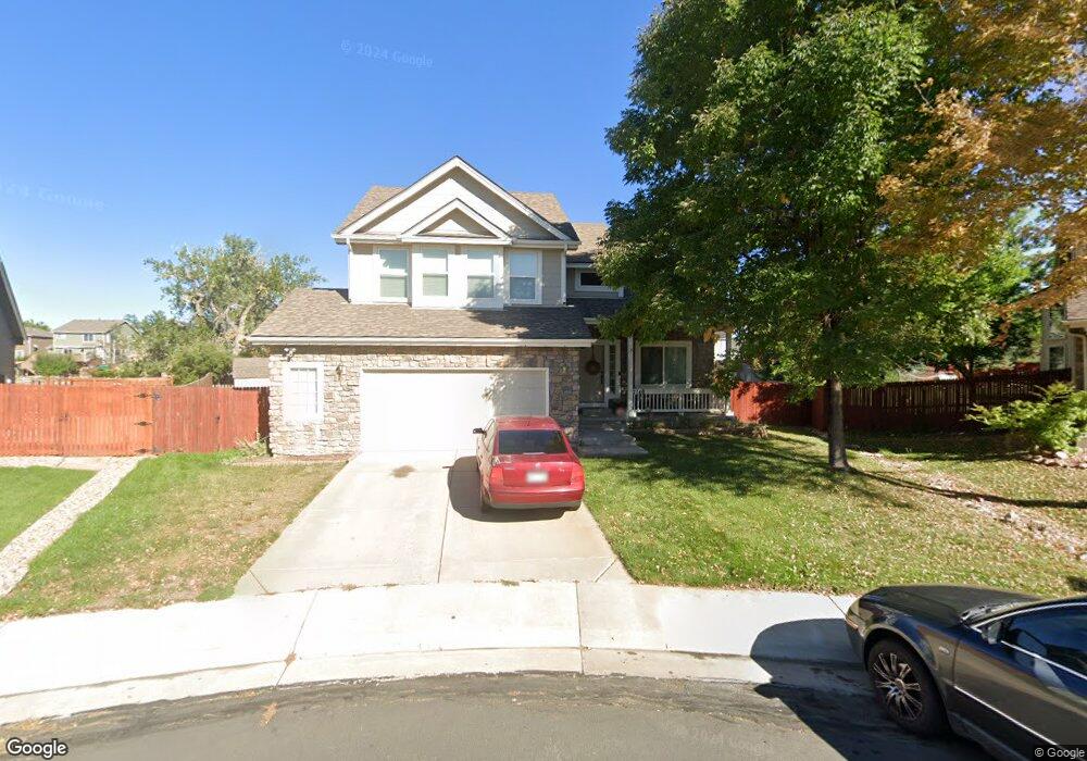
2140 E 133rd Way Thornton, CO 80241
Estimated Value: $553,414 - $627,000
4
Beds
3
Baths
2,717
Sq Ft
$217/Sq Ft
Est. Value
About This Home
This home is located at 2140 E 133rd Way, Thornton, CO 80241 and is currently estimated at $589,104, approximately $216 per square foot. 2140 E 133rd Way is a home located in Adams County with nearby schools including Hunters Glen Elementary School, Century Middle School, and Mountain Range High School.
Ownership History
Date
Name
Owned For
Owner Type
Purchase Details
Closed on
Jan 29, 2026
Sold by
Bissani Kaily
Bought by
Bissani Family Trust and Bissani
Current Estimated Value
Purchase Details
Closed on
Apr 22, 2011
Sold by
Secretary Of Housing & Urban Development
Bought by
Bissani Kaily
Home Financials for this Owner
Home Financials are based on the most recent Mortgage that was taken out on this home.
Original Mortgage
$149,250
Interest Rate
4.91%
Mortgage Type
New Conventional
Purchase Details
Closed on
Jan 4, 2011
Sold by
Lovato Dan E
Bought by
The Secretary Of Housing & Urban Develop
Purchase Details
Closed on
Jun 29, 1999
Sold by
Engle Homes Colorado Inc
Bought by
Lovato Dan E
Home Financials for this Owner
Home Financials are based on the most recent Mortgage that was taken out on this home.
Original Mortgage
$203,000
Interest Rate
7.21%
Mortgage Type
FHA
Create a Home Valuation Report for This Property
The Home Valuation Report is an in-depth analysis detailing your home's value as well as a comparison with similar homes in the area
Purchase History
| Date | Buyer | Sale Price | Title Company |
|---|---|---|---|
| Bissani Family Trust | -- | None Listed On Document | |
| Bissani Kaily | $199,000 | Ats | |
| The Secretary Of Housing & Urban Develop | -- | None Available | |
| Lovato Dan E | $207,100 | Universal Land Title |
Source: Public Records
Mortgage History
| Date | Status | Borrower | Loan Amount |
|---|---|---|---|
| Previous Owner | Bissani Kaily | $149,250 | |
| Previous Owner | Lovato Dan E | $203,000 |
Source: Public Records
Tax History
| Year | Tax Paid | Tax Assessment Tax Assessment Total Assessment is a certain percentage of the fair market value that is determined by local assessors to be the total taxable value of land and additions on the property. | Land | Improvement |
|---|---|---|---|---|
| 2025 | $3,837 | $39,030 | $8,160 | $30,870 |
| 2024 | $3,837 | $35,880 | $7,500 | $28,380 |
| 2023 | $3,798 | $40,790 | $7,170 | $33,620 |
| 2022 | $3,219 | $29,220 | $7,370 | $21,850 |
| 2021 | $3,326 | $29,220 | $7,370 | $21,850 |
| 2020 | $3,252 | $29,150 | $7,580 | $21,570 |
| 2019 | $3,259 | $29,150 | $7,580 | $21,570 |
| 2018 | $3,002 | $26,090 | $7,490 | $18,600 |
| 2017 | $2,730 | $26,090 | $7,490 | $18,600 |
| 2016 | $2,718 | $25,290 | $4,940 | $20,350 |
| 2015 | $2,714 | $25,290 | $4,940 | $20,350 |
| 2014 | $2,601 | $22,540 | $4,460 | $18,080 |
Source: Public Records
Map
Nearby Homes
- 58 Blue Heron Dr
- 13337 Elizabeth Ct
- 2746 E 132nd Place
- 13508 Vine St
- 2942 E 135th Place
- 2973 E 133rd Ln
- 7 Sandpiper Cir
- 2066 E 129th Ave
- 2275 E 129th Ave
- 1672 E 131st Ct
- 1960 E 135th Place
- 2615 Signal Creek Dr
- 2297 E 128th Ave
- 12885 Vine St
- 12905 Lafayette St Unit H
- 1162 E 130th Ave Unit B
- 13488 Monroe St
- 1174 E 130th Dr
- 12829 Cook Dr
- 12560 Josephine St
- 2130 E 133rd Way
- 2135 E 133rd Way
- 2120 E 133rd Way
- 2125 E 133rd Way
- 2080 E 134th Ave
- 2115 E 133rd Way
- 2110 E 133rd Way
- 2095 E 133rd Way
- 37 Blue Heron Dr
- 13283 Columbine Cir
- 13287 Columbine Cir
- 13275 Columbine Cir
- 13291 Columbine Cir
- 13267 Columbine Cir
- 2100 E 133rd Way
- 13259 Columbine Cir
- 13301 Columbine Cir
- 2085 E 133rd Way
- 13251 Columbine Cir
- 13307 Columbine Cir
Your Personal Tour Guide
Ask me questions while you tour the home.