Estimated Value: $108,000 - $142,000
3
Beds
1
Bath
1,188
Sq Ft
$109/Sq Ft
Est. Value
About This Home
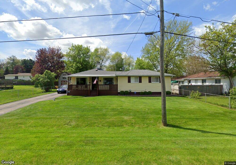
This home is located at 2140 Eberly Rd, Flint, MI 48532 and is currently estimated at $129,438, approximately $108 per square foot. 2140 Eberly Rd is a home located in Genesee County with nearby schools including Carman-Ainsworth High School, Genesee STEM Academy, and St. Paul Lutheran School.
Ownership History
Date
Name
Owned For
Owner Type
Purchase Details
Closed on
Sep 24, 2014
Sold by
Bennett Cindy L
Bought by
Bennett Cindy L and Birtzer Terri L
Current Estimated Value
Purchase Details
Closed on
Jul 11, 2014
Sold by
Birtzer Terri L and Hodorovich Joseph E
Bought by
Bennett Cindy L
Home Financials for this Owner
Home Financials are based on the most recent Mortgage that was taken out on this home.
Original Mortgage
$48,100
Interest Rate
4.1%
Mortgage Type
New Conventional
Purchase Details
Closed on
Nov 15, 2013
Sold by
Bennett Cindy L
Bought by
Bennett Cindy L and Birtzer Terri L
Purchase Details
Closed on
Jun 22, 2004
Sold by
Bennett Cindy L and Newell Randy J
Bought by
Bennett Cindy L
Create a Home Valuation Report for This Property
The Home Valuation Report is an in-depth analysis detailing your home's value as well as a comparison with similar homes in the area
Home Values in the Area
Average Home Value in this Area
Purchase History
| Date | Buyer | Sale Price | Title Company |
|---|---|---|---|
| Bennett Cindy L | -- | None Available | |
| Bennett Cindy L | -- | First American Title Ins Co | |
| Bennett Cindy L | -- | None Available | |
| Bennett Cindy L | -- | -- |
Source: Public Records
Mortgage History
| Date | Status | Borrower | Loan Amount |
|---|---|---|---|
| Previous Owner | Bennett Cindy L | $48,100 |
Source: Public Records
Tax History
| Year | Tax Paid | Tax Assessment Tax Assessment Total Assessment is a certain percentage of the fair market value that is determined by local assessors to be the total taxable value of land and additions on the property. | Land | Improvement |
|---|---|---|---|---|
| 2025 | $1,456 | $63,700 | $0 | $0 |
| 2024 | $711 | $55,900 | $0 | $0 |
| 2023 | $1,112 | $51,800 | $0 | $0 |
| 2022 | $671 | $37,700 | $0 | $0 |
| 2021 | $1,286 | $32,100 | $0 | $0 |
| 2020 | $610 | $30,200 | $0 | $0 |
| 2019 | $601 | $27,000 | $0 | $0 |
| 2018 | $1,193 | $29,000 | $0 | $0 |
| 2017 | $1,153 | $29,000 | $0 | $0 |
| 2016 | $1,184 | $28,700 | $0 | $0 |
| 2015 | $1,010 | $26,300 | $0 | $0 |
| 2014 | $599 | $25,100 | $0 | $0 |
| 2012 | -- | $29,500 | $29,500 | $0 |
Source: Public Records
Map
Nearby Homes
- 2033 Eberly Rd
- 18.41 Taft Rd
- 1512 Crescent Lane Dr Lot#46
- 10 Acres T A Mansour Blvd
- 3277 Whitney Ave
- 4199 Sheraton Dr
- 4474 Corunna Rd
- 1455 S Linden Rd
- 4480 Corunna Rd
- VL Clairmont St
- 4335 Lennon Rd
- 3365 Ridgecliffe Dr
- 3349 Ridgecliffe Dr
- 3088 Curtis Dr
- 2521 White Oak Place
- 0 Charter Dr Unit 50153638
- 3.9 Acres W Court St
- 4490 W Lennon Rd
- 3918 Larchmont St
- 3139 Red Barn Rd
Your Personal Tour Guide
Ask me questions while you tour the home.