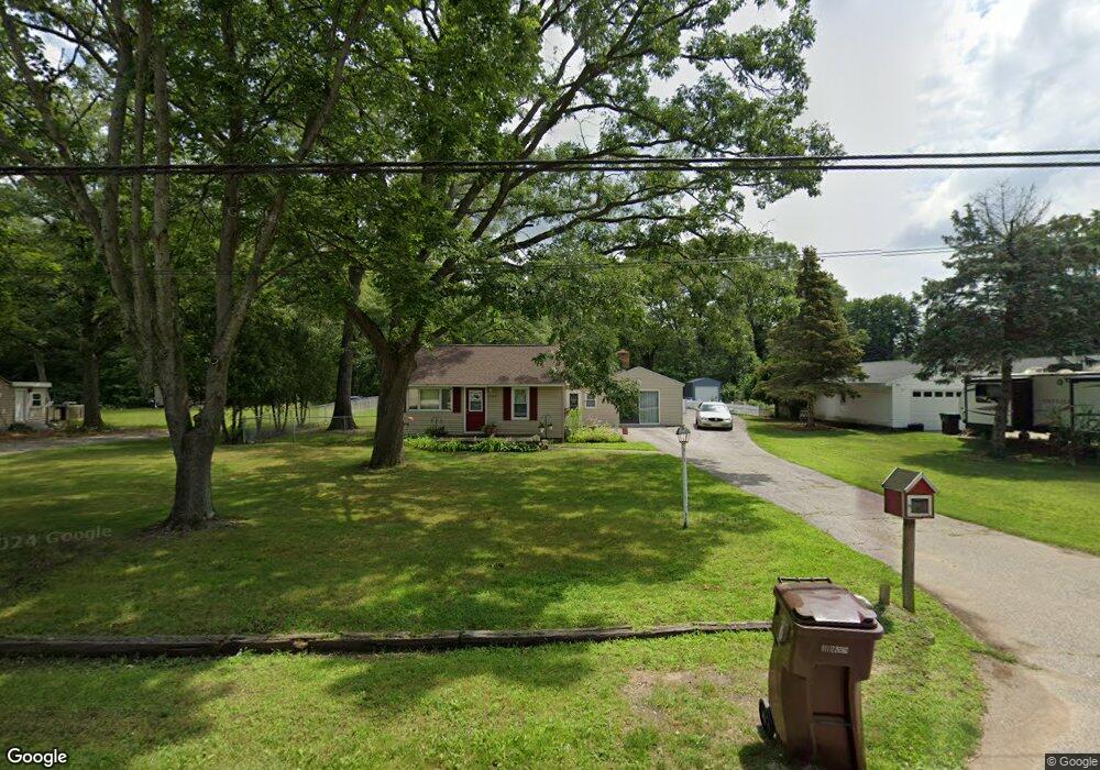
2140 S Dangl Rd Muskegon, MI 49442
Estimated Value: $206,000 - $220,000
2
Beds
1
Bath
1,159
Sq Ft
$182/Sq Ft
Est. Value
About This Home
This home is located at 2140 S Dangl Rd, Muskegon, MI 49442 and is currently estimated at $210,661, approximately $181 per square foot. 2140 S Dangl Rd is a home located in Muskegon County with nearby schools including Orchard View Early Elementary School, Cardinal Elementary School, and Orchard View Middle School.
Ownership History
Date
Name
Owned For
Owner Type
Purchase Details
Closed on
Jan 11, 2008
Sold by
Horsly Sharon K and Horsly Rick A
Bought by
Deutsche Bank National Trust Co and Home Equity Mortgage Loan Asset Backed T
Current Estimated Value
Purchase Details
Closed on
Nov 16, 2007
Sold by
Horsly Sharon K and Horsly Rick A
Bought by
Deutsche Bank National Trust Co and Home Equity Mortgage Loan Asset Backed T
Purchase Details
Closed on
Dec 1, 2006
Sold by
Horsly Rick A and Horsly Sharon K
Bought by
Citicorp Trust Bank and Travelers Bank & Trust Fsb
Create a Home Valuation Report for This Property
The Home Valuation Report is an in-depth analysis detailing your home's value as well as a comparison with similar homes in the area
Home Values in the Area
Average Home Value in this Area
Purchase History
| Date | Buyer | Sale Price | Title Company |
|---|---|---|---|
| Deutsche Bank National Trust Co | $75,600 | None Available | |
| Deutsche Bank National Trust Co | $75,600 | None Available | |
| Citicorp Trust Bank | $59,900 | None Available |
Source: Public Records
Tax History Compared to Growth
Tax History
| Year | Tax Paid | Tax Assessment Tax Assessment Total Assessment is a certain percentage of the fair market value that is determined by local assessors to be the total taxable value of land and additions on the property. | Land | Improvement |
|---|---|---|---|---|
| 2025 | $1,602 | $84,300 | $0 | $0 |
| 2024 | $476 | $77,300 | $0 | $0 |
| 2023 | $455 | $69,500 | $0 | $0 |
| 2022 | $1,463 | $61,000 | $0 | $0 |
| 2021 | $1,425 | $54,300 | $0 | $0 |
| 2020 | $1,411 | $50,800 | $0 | $0 |
| 2019 | $1,391 | $45,900 | $0 | $0 |
| 2018 | $1,319 | $40,700 | $0 | $0 |
| 2017 | $1,292 | $40,300 | $0 | $0 |
| 2016 | $388 | $37,500 | $0 | $0 |
| 2015 | -- | $35,500 | $0 | $0 |
| 2014 | -- | $34,600 | $0 | $0 |
| 2013 | -- | $32,100 | $0 | $0 |
Source: Public Records
Map
Nearby Homes
- 2362 Debaker Rd
- 3626 E Laketon Ave
- VL Olthoff Dr
- 1476 Frost St
- 2852 Devowe St
- 3878 E Laketon Ave
- 1907 S Brooks Rd
- 2449 E Laketon Ave
- 2054 Ironwood Ct W
- 2325 S Sheridan Dr
- 1946 Spyglass Trail
- 2125 Woodward St
- 1978 Colonial Ln
- 2488 E Broadway Ave
- 2576 Vine Ave
- 2048 Center St
- 2049 Center St
- 1832 Pepperwood Trail S
- 4210 Tasal Trail
- 1441 S Brooks Rd
- 2154 S Dangl Rd
- 2126 S Dangl Rd
- 2145 S Dangl Rd
- 2137 S Dangl Rd
- 2110 S Dangl Rd
- 2159 S Dangl Rd
- 2115 S Dangl Rd
- 3214 Evanston Ave
- 3226 Evanston Ave
- 2171 S Dangl Rd
- 3238 Evanston Ave
- 2078 S Dangl Rd
- 3250 Evanston Ave
- 2077 S Dangl Rd
- 3264 Evanston Ave
- 2065 S Dangl Rd
- 3231 Evanston Ave
- 2048 S Dangl Rd
- 3241 Evanston Ave
- 3189 Evanston Ave