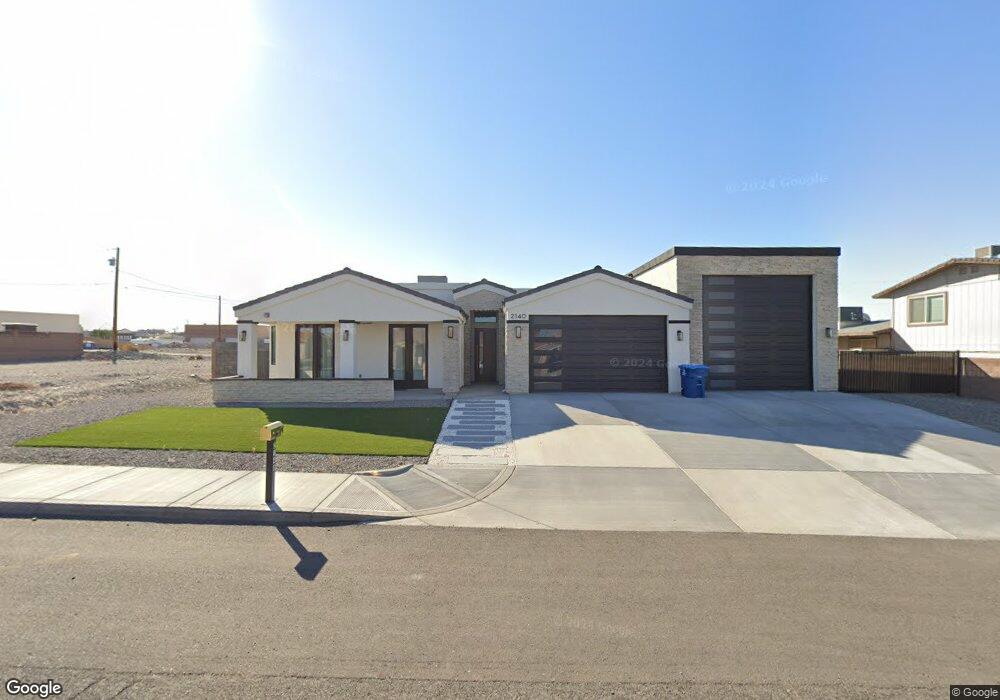
2140 Sahara Lake Havasu City, AZ 86403
Estimated Value: $667,000 - $989,244
--
Bed
--
Bath
1,972
Sq Ft
$412/Sq Ft
Est. Value
About This Home
This home is located at 2140 Sahara, Lake Havasu City, AZ 86403 and is currently estimated at $811,561, approximately $411 per square foot. 2140 Sahara is a home located in Mohave County with nearby schools including Havasupai Elementary School, Thunderbolt Middle School, and Lake Havasu High School.
Ownership History
Date
Name
Owned For
Owner Type
Purchase Details
Closed on
May 21, 2020
Sold by
Rae Bruce D
Bought by
Webb Forrest and Webb Marlyn
Current Estimated Value
Purchase Details
Closed on
Aug 4, 2017
Sold by
Rae Bruce D
Bought by
Rae Bruce D
Purchase Details
Closed on
Oct 9, 2007
Sold by
Rae Susan M Mc Gonigle
Bought by
Rae Bruce D
Purchase Details
Closed on
Dec 15, 2003
Sold by
Cariaga Alex J and Cariaga Lupe
Bought by
Rae Bruce D and Rae Susan M Mc Gonigle
Home Financials for this Owner
Home Financials are based on the most recent Mortgage that was taken out on this home.
Original Mortgage
$40,625
Interest Rate
6.02%
Mortgage Type
Unknown
Create a Home Valuation Report for This Property
The Home Valuation Report is an in-depth analysis detailing your home's value as well as a comparison with similar homes in the area
Home Values in the Area
Average Home Value in this Area
Purchase History
| Date | Buyer | Sale Price | Title Company |
|---|---|---|---|
| Webb Forrest | $87,000 | Chicago Title Agency Inc | |
| Rae Bruce D | -- | None Available | |
| Rae Bruce D | -- | State Title Agency Inc | |
| Rae Bruce D | $62,500 | State Title Agency Inc |
Source: Public Records
Mortgage History
| Date | Status | Borrower | Loan Amount |
|---|---|---|---|
| Previous Owner | Rae Bruce D | $40,625 |
Source: Public Records
Tax History Compared to Growth
Tax History
| Year | Tax Paid | Tax Assessment Tax Assessment Total Assessment is a certain percentage of the fair market value that is determined by local assessors to be the total taxable value of land and additions on the property. | Land | Improvement |
|---|---|---|---|---|
| 2026 | $1,392 | -- | -- | -- |
| 2025 | $438 | $78,234 | $0 | $0 |
| 2024 | $438 | $70,504 | $0 | $0 |
| 2023 | $438 | $14,615 | $0 | $0 |
| 2022 | $419 | $9,446 | $0 | $0 |
| 2021 | $563 | $10,007 | $0 | $0 |
| 2019 | $540 | $7,495 | $0 | $0 |
| 2018 | $525 | $6,578 | $0 | $0 |
| 2017 | $521 | $6,503 | $0 | $0 |
| 2016 | $482 | $6,222 | $0 | $0 |
| 2015 | $488 | $5,095 | $0 | $0 |
Source: Public Records
Map
Nearby Homes
- 2100 Chaparral Dr
- 2090 San Juan Dr
- 2301 Sahara Dr
- 1911 Holly Ave
- 1901 Holly Ave
- 1541 Holly Ave
- 2021 Industrial
- 2200 Clarke Dr
- 1986 Bahama Ave
- 2257 Barranca Dr
- 640 Acoma Blvd N
- 2030 Commander Dr
- 1960 Pirate Ln
- 2091 Holly Ave
- 2162 Runabout Dr
- 2285 Pennant Ln
- 583 Robin Ln
- 2272 Barranca Dr
- 2264 Barranca Dr
- 675 Knobhill Ln
- 2130 Sahara Dr Unit 2
- 2130 Sahara Dr Unit 4
- 2130 Sahara Dr Unit 3
- 2130 Sahara Dr
- 2150 Sahara Dr
- 2150 Sahara Dr
- 2160 Sahara Dr
- 2160 Sahara Dr
- 2151 Sahara Dr
- 2151 Sahara Dr
- 2120 Sahara Dr
- 2161 Sahara Dr
- 2175 Sahara Dr
- 2185 Sahara Dr
- 2131 Sahara Dr
- 2170 Sahara Dr
- 2110 Sahara Dr
- 2110 Sahara Dr
- 2191 Acoma Blvd W
- 2185 Acoma Blvd W