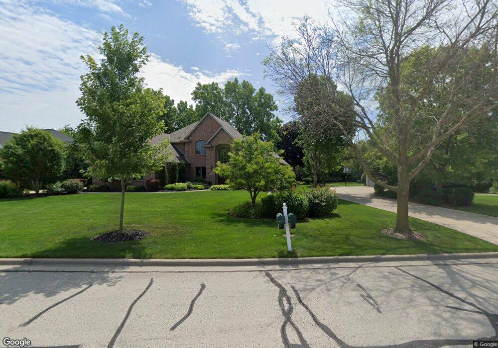
2140 Swanstone Cir de Pere, WI 54115
Estimated Value: $577,000 - $647,000
--
Bed
--
Bath
--
Sq Ft
1.14
Acres
About This Home
This home is located at 2140 Swanstone Cir, de Pere, WI 54115 and is currently estimated at $617,234. 2140 Swanstone Cir is a home located in Brown County with nearby schools including Heritage Elementary School, De Pere Middle School, and Foxview Intermediate School.
Ownership History
Date
Name
Owned For
Owner Type
Purchase Details
Closed on
May 17, 2023
Sold by
Sharma Ajeet D and Sharma Sharon L
Bought by
Sharma Ajeet D and Sharma Sharon L
Current Estimated Value
Purchase Details
Closed on
Jul 29, 2005
Sold by
Gmack Joel A and Gmack Lori J
Bought by
Sharma Ajeet D and Sharma Sharon L
Home Financials for this Owner
Home Financials are based on the most recent Mortgage that was taken out on this home.
Original Mortgage
$343,900
Interest Rate
5.71%
Mortgage Type
Fannie Mae Freddie Mac
Create a Home Valuation Report for This Property
The Home Valuation Report is an in-depth analysis detailing your home's value as well as a comparison with similar homes in the area
Home Values in the Area
Average Home Value in this Area
Purchase History
| Date | Buyer | Sale Price | Title Company |
|---|---|---|---|
| Sharma Ajeet D | -- | -- | |
| Sharma Ajeet D | $429,900 | Liberty Title |
Source: Public Records
Mortgage History
| Date | Status | Borrower | Loan Amount |
|---|---|---|---|
| Previous Owner | Sharma Ajeet D | $343,900 |
Source: Public Records
Tax History Compared to Growth
Tax History
| Year | Tax Paid | Tax Assessment Tax Assessment Total Assessment is a certain percentage of the fair market value that is determined by local assessors to be the total taxable value of land and additions on the property. | Land | Improvement |
|---|---|---|---|---|
| 2024 | $7,456 | $510,700 | $84,100 | $426,600 |
| 2023 | $6,629 | $510,700 | $84,100 | $426,600 |
| 2022 | $6,064 | $510,700 | $84,100 | $426,600 |
| 2021 | $5,602 | $367,600 | $70,000 | $297,600 |
| 2020 | $5,551 | $367,600 | $70,000 | $297,600 |
| 2019 | $6,012 | $367,600 | $70,000 | $297,600 |
| 2018 | $6,167 | $367,600 | $70,000 | $297,600 |
| 2017 | $6,097 | $367,600 | $70,000 | $297,600 |
| 2016 | $6,304 | $321,400 | $61,500 | $259,900 |
| 2015 | $6,480 | $321,400 | $61,500 | $259,900 |
| 2014 | $6,434 | $321,400 | $61,500 | $259,900 |
| 2013 | $6,434 | $321,400 | $61,500 | $259,900 |
Source: Public Records
Map
Nearby Homes
- 1653 Remington Ridge Way Unit 1653
- 1655 Remington Ridge Way Unit 1655
- 1658 Remington Ridge Way Unit 1658
- 1724 Remington Ridge Way Unit 1724
- 1853 Swan Rd
- 1871 Ledgeview Rd
- 1144 Jordan Rd
- 2206 Blue Stem Ln
- 0 S Broadway St
- 2188 Trellis Dr
- 3910 Monroe Rd
- 906 Silver St
- 3980 N Parker Way
- 2200 Dickinson Rd
- 821 Killarny Trail Unit 1
- 2171 Trailside Ln Unit 16
- 1764 Other
- 1403 Quinnette Ln
- 830 Roth Rd
- 801 S Erie St
- 2146 Swanstone Cir
- 2134 Swanstone Cir
- 2152 Swanstone Cir
- 2147 Swanstone Cir
- 2128 Swanstone Cir
- 2139 Swanstone Cir
- 2133 Swanstone Cir
- 2161 Swanstone Cir
- 2122 Swanstone Cir
- 2158 Swanstone Cir
- 2127 Swanstone Cir
- 2051 Whistling Swan Cir
- 2171 Swanstone Cir
- 2164 Swanstone Cir
- 2121 Swanstone Cir
- 2045 Whistling Swan Cir
- 2116 Swanstone Cir
- 2170 Swanstone Cir
- 2177 Swanstone Cir
- 2115 Swanstone Cir