
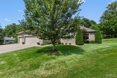
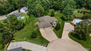
2146 Rampart St Cape Girardeau, MO 63701
Estimated payment $3,909/month
Highlights
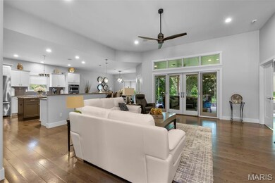
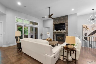
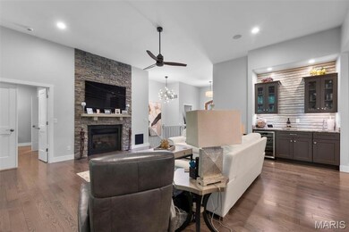
- Family Room with Fireplace
- Wood Flooring
- Cul-De-Sac
- Ranch Style House
- No HOA
- 3 Car Attached Garage
About This Home
Seller is a Mo licensed realtor
Home Details
Home Type
- Single Family
Est. Annual Taxes
- $4,176
Year Built
- Built in 2016
Lot Details
- 0.76 Acre Lot
- Cul-De-Sac
Parking
- 3 Car Attached Garage
Home Design
- Ranch Style House
- Traditional Architecture
- Brick Exterior Construction
- Stone
Interior Spaces
- Ceiling Fan
- Gas Log Fireplace
- Family Room with Fireplace
- 2 Fireplaces
- Great Room with Fireplace
- Dining Room
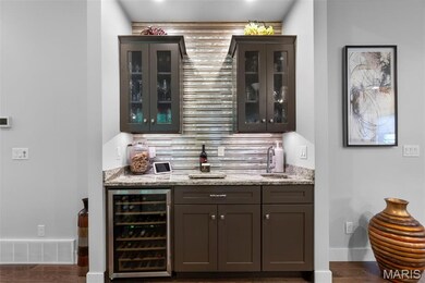
Kitchen
- Gas Cooktop
- Microwave
- Dishwasher
- Wine Cooler
- Trash Compactor
- Disposal
Flooring
- Wood
- Ceramic Tile
- Vinyl
Bedrooms and Bathrooms
- 5 Bedrooms
Laundry
- Laundry Room
- Laundry on main level
- Sink Near Laundry
Basement
- Walk-Out Basement
- Basement Fills Entire Space Under The House
- 9 Foot Basement Ceiling Height
- Finished Basement Bathroom
Schools
- Alma Schrader Elem. Elementary School
- Central Jr. High Middle School
- Central High School
Utilities
- Forced Air Heating and Cooling System
- Heating System Uses Natural Gas
- 220 Volts
- Cable TV Available
Community Details
- No Home Owners Association
Listing and Financial Details
- Home warranty included in the sale of the property
- Assessor Parcel Number 15-619-00-15-00700-0000
Map
Home Values in the Area
Average Home Value in this Area
Tax History
| Year | Tax Paid | Tax Assessment Tax Assessment Total Assessment is a certain percentage of the fair market value that is determined by local assessors to be the total taxable value of land and additions on the property. | Land | Improvement |
|---|---|---|---|---|
| 2025 | $4,176 | $79,960 | $5,930 | $74,030 |
| 2024 | $40 | $76,150 | $5,650 | $70,500 |
| 2023 | $3,958 | $76,150 | $5,650 | $70,500 |
| 2022 | $3,650 | $70,190 | $5,210 | $64,980 |
| 2021 | $3,649 | $70,190 | $5,210 | $64,980 |
| 2020 | $3,660 | $70,190 | $5,210 | $64,980 |
| 2019 | $3,655 | $70,190 | $0 | $0 |
| 2018 | $3,648 | $70,190 | $0 | $0 |
| 2017 | $3,656 | $70,190 | $0 | $0 |
| 2016 | $195 | $3,760 | $0 | $0 |
| 2015 | $195 | $3,760 | $0 | $0 |
| 2014 | $443 | $3,760 | $0 | $0 |
Property History
| Date | Event | Price | List to Sale | Price per Sq Ft |
|---|---|---|---|---|
| 11/20/2025 11/20/25 | Pending | -- | -- | -- |
| 11/20/2025 11/20/25 | For Sale | $679,000 | -- | $200 / Sq Ft |
Purchase History
| Date | Type | Sale Price | Title Company |
|---|---|---|---|
| Warranty Deed | -- | -- | |
| Warranty Deed | -- | -- | |
| Warranty Deed | -- | -- | |
| Warranty Deed | -- | -- | |
| Warranty Deed | -- | -- |
Mortgage History
| Date | Status | Loan Amount | Loan Type |
|---|---|---|---|
| Previous Owner | $250,000 | New Conventional |
Source: MARIS MLS
MLS Number: MIS25077406
APN: 15-619-00-15-00700-0000
Disclaimer: Certain information contained herein is derived from information provided by parties other than Homes.com. All information provided is deemed reliable, but is not guaranteed to be accurate and should be independently verified.
![]() Based on information submitted to the MLS GRID. All data is obtained from various sources and may not have been verified by broker or MLS GRID. Supplied Open House Information is subject to change without notice. All information should be independently reviewed and verified for accuracy. Properties may or may not be listed by the office/agent presenting the information. Some IDX listings have been excluded from this website.
Based on information submitted to the MLS GRID. All data is obtained from various sources and may not have been verified by broker or MLS GRID. Supplied Open House Information is subject to change without notice. All information should be independently reviewed and verified for accuracy. Properties may or may not be listed by the office/agent presenting the information. Some IDX listings have been excluded from this website.
The Digital Millennium Copyright Act of 1998, 17 U.S.C. § 512 (the “DMCA”) provides recourse for copyright owners who believe that material appearing on the Internet infringes their rights under U.S. copyright law. If you believe in good faith that any content or material made available in connection with our website or services infringes your copyright, you (or your agent) may send us a notice requesting that the content or material be removed, or access to it blocked.
Notices must be sent in writing by email to DMCAnotice@MLSGrid.com.
The DMCA requires that your notice of alleged copyright infringement include the following information:
(1) description of the copyrighted work that is the subject of claimed infringement;
(2) description of the alleged infringing content and information sufficient to permit us to locate the content;
(3) contact information for you, including your address, telephone number and email address;
(4) a statement by you that you have a good faith belief that the content in the manner complained of is not authorized by the copyright owner, or its agent, or by the operation of any law;
(5) a statement by you, signed under penalty of perjury, that the information in the notification is accurate and that you have the authority to enforce the copyrights that are claimed to be infringed; and
(6) a physical or electronic signature of the copyright owner or a person authorized to act on the copyright owner’s behalf. Failure to include all of the above information may result in the delay of the processing of your complaint.
- 2322 Belleridge Pike
- 2528 Palomino Dr
- 1966 Randol Ave
- 3055/3057 Patriot Dr
- 1705 Paul Revere Dr
- 2720 Partridge Ct
- 1960 Briarwood Dr
- 1623 Lexington Ave
- 2313 Hillbrook Dr
- 2856 Alta Cuesta Dr
- 1912 Perryville Rd
- 1608 Lexington Ave
- 2237 Sherwood Dr
- 1736 El Rio Dr
- 1577 Saratoga St
- 2153 Esker Trail
- 2640 Walden Blvd
- 2161 Esker Trail
- 2224 Heywood Meadows
- 1572 Lexington Ave
