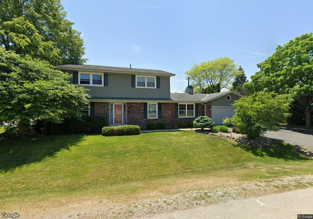
2148 Sutton Dr Mount Pleasant, WI 53406
Estimated Value: $413,418 - $464,000
4
Beds
3
Baths
2,151
Sq Ft
$205/Sq Ft
Est. Value
About This Home
This home is located at 2148 Sutton Dr, Mount Pleasant, WI 53406 and is currently estimated at $440,355, approximately $204 per square foot. 2148 Sutton Dr is a home located in Racine County with nearby schools including Gifford Elementary School, Park High School, and Racine Christian School.
Ownership History
Date
Name
Owned For
Owner Type
Purchase Details
Closed on
May 20, 2016
Sold by
Weiss Robert C and Weiss Kristine K
Bought by
Sego Eric J and Witkofski Sego Jennifer M
Current Estimated Value
Home Financials for this Owner
Home Financials are based on the most recent Mortgage that was taken out on this home.
Original Mortgage
$199,409
Outstanding Balance
$160,524
Interest Rate
4.5%
Mortgage Type
FHA
Estimated Equity
$279,831
Create a Home Valuation Report for This Property
The Home Valuation Report is an in-depth analysis detailing your home's value as well as a comparison with similar homes in the area
Home Values in the Area
Average Home Value in this Area
Purchase History
| Date | Buyer | Sale Price | Title Company |
|---|---|---|---|
| Sego Eric J | $205,000 | None Available |
Source: Public Records
Mortgage History
| Date | Status | Borrower | Loan Amount |
|---|---|---|---|
| Open | Sego Eric J | $199,409 |
Source: Public Records
Tax History
| Year | Tax Paid | Tax Assessment Tax Assessment Total Assessment is a certain percentage of the fair market value that is determined by local assessors to be the total taxable value of land and additions on the property. | Land | Improvement |
|---|---|---|---|---|
| 2025 | $6,502 | $403,000 | $56,500 | $346,500 |
| 2024 | $6,101 | $376,900 | $56,500 | $320,400 |
| 2023 | $7,234 | $368,600 | $52,700 | $315,900 |
| 2022 | $6,894 | $348,100 | $52,700 | $295,400 |
| 2021 | $7,080 | $317,300 | $47,900 | $269,400 |
| 2020 | $6,131 | $264,600 | $43,100 | $221,500 |
| 2019 | $5,552 | $264,600 | $43,100 | $221,500 |
| 2018 | $5,094 | $231,200 | $36,300 | $194,900 |
| 2017 | $4,266 | $212,000 | $36,300 | $175,700 |
| 2016 | $4,241 | $195,100 | $29,000 | $166,100 |
| 2015 | $4,001 | $195,100 | $29,000 | $166,100 |
| 2014 | $3,779 | $195,100 | $29,000 | $166,100 |
| 2013 | $4,599 | $195,100 | $29,000 | $166,100 |
Source: Public Records
Map
Nearby Homes
- 2235 N Newman Rd
- 1929 Independence Way
- 1927 Independence Way
- 5357 Independence Rd
- 5359 Independence Rd
- 6147 Carriage Hills Dr
- 2101 N Emmertsen Rd
- 5701 Cambridge Cir Unit 5
- 5720 Cambridge Cir Unit 1
- 5742 Cambridge Cir Unit 5
- 5835 Cambridge Cir Unit 1
- 5740 Cambridge Ln Unit 3
- 2536 Green Haze Ave
- 6130 Northwestern Ave
- 2620 Penbrook Dr
- 5917 Blazing Star Dr
- 3232 Bergamot Dr
- 1315 N Sunnyslope Dr Unit 202
- 3242 Bergamot Dr
- 3234 Blue Star Cir
- 2140 Sutton Dr
- 2147 Ramada Dr
- 2134 Sutton Dr
- 5700 Embassy Dr
- 2139 Ramada Dr
- 5622 Riviera Dr
- 5710 Embassy Dr
- 5636 Embassy Dr
- 5624 Embassy Dr
- 2131 Ramada Dr
- 5621 Riviera Dr
- 2126 Sutton Dr
- Lt1 Embassy Dr Unit Lt1
- 5730 Embassy Dr
- 5612 Riviera Dr
- 2125 Sutton Dr
- 5643 Sandy Ln
- 5709 Sandy Ln
- 2123 Ramada Dr
- 5701 Embassy Dr
Your Personal Tour Guide
Ask me questions while you tour the home.