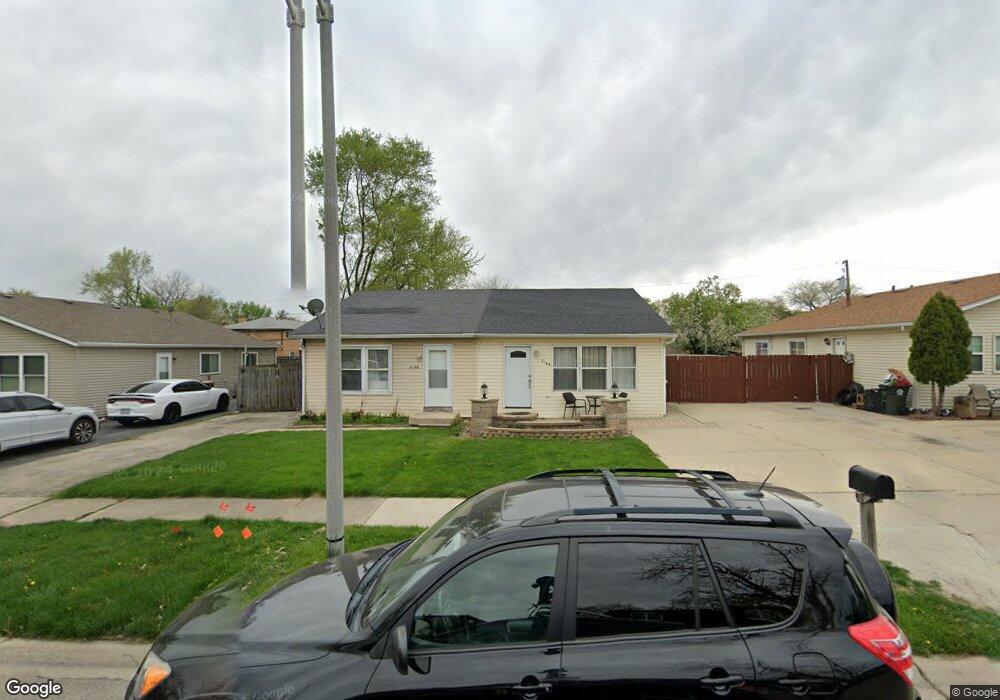
214A Laurel Dr North Aurora, IL 60542
Estimated Value: $184,000 - $211,000
--
Bed
--
Bath
860
Sq Ft
$234/Sq Ft
Est. Value
About This Home
This home is located at 214A Laurel Dr, North Aurora, IL 60542 and is currently estimated at $200,951, approximately $233 per square foot. 214A Laurel Dr is a home located in Kane County with nearby schools including Schneider Elementary School, Herget Middle School, and West Aurora High School.
Ownership History
Date
Name
Owned For
Owner Type
Purchase Details
Closed on
Jun 18, 1999
Sold by
Lecompte Donald W
Bought by
Lecompte Kelley K
Current Estimated Value
Purchase Details
Closed on
Aug 2, 1994
Sold by
Lecompte Kelley K and Alway Kelly K
Bought by
Lecompte Kelly K and Lecompte Donald W
Home Financials for this Owner
Home Financials are based on the most recent Mortgage that was taken out on this home.
Original Mortgage
$40,875
Interest Rate
8.62%
Create a Home Valuation Report for This Property
The Home Valuation Report is an in-depth analysis detailing your home's value as well as a comparison with similar homes in the area
Home Values in the Area
Average Home Value in this Area
Purchase History
| Date | Buyer | Sale Price | Title Company |
|---|---|---|---|
| Lecompte Kelley K | -- | -- | |
| Lecompte Kelly K | -- | Law Title Ins Co | |
| Lecompte Donald W | -- | Law Title Ins Co |
Source: Public Records
Mortgage History
| Date | Status | Borrower | Loan Amount |
|---|---|---|---|
| Closed | Lecompte Donald W | $40,875 |
Source: Public Records
Tax History Compared to Growth
Tax History
| Year | Tax Paid | Tax Assessment Tax Assessment Total Assessment is a certain percentage of the fair market value that is determined by local assessors to be the total taxable value of land and additions on the property. | Land | Improvement |
|---|---|---|---|---|
| 2024 | $3,164 | $42,086 | $7,823 | $34,263 |
| 2023 | $3,113 | $38,256 | $7,159 | $31,097 |
| 2022 | $2,955 | $35,754 | $6,691 | $29,063 |
| 2021 | $2,883 | $33,910 | $6,346 | $27,564 |
| 2020 | $2,877 | $33,258 | $6,224 | $27,034 |
| 2019 | $2,916 | $32,081 | $6,004 | $26,077 |
| 2018 | $2,901 | $30,859 | $5,775 | $25,084 |
| 2017 | $2,888 | $29,842 | $5,585 | $24,257 |
| 2016 | $2,889 | $28,972 | $5,422 | $23,550 |
| 2015 | -- | $28,313 | $5,299 | $23,014 |
| 2014 | -- | $27,422 | $5,132 | $22,290 |
| 2013 | -- | $26,887 | $5,032 | $21,855 |
Source: Public Records
Map
Nearby Homes
- 317 Butterfield Rd
- 203 Hill Ave
- 113 April Ln
- 242 Sussex Ln
- 273 Ridley St
- 24 S Grant St
- 719 Pinecreek Dr
- 616 Pinehurst Dr
- 509 Wingfoot Dr
- 239 Durham St
- 310 Oak St
- 355 Hilltop Dr
- 952 Darwin St
- 451 Pheasant Hill Dr
- 220 Larchwood Ln
- 328 W State St
- 444 Prairie Ridge Ln
- 556 Quail St
- 448 Prairie Ridge Ln
- 572 Quail Ln
- 214B Laurel Dr
- 212B Laurel Dr
- 216 Laurel Dr Unit A
- 216 Laurel Dr Unit B
- 212A Laurel Dr
- 210B Laurel Dr
- 215 Linn Ct Unit B
- 215 Linn Ct Unit A
- 215 Linn Ct Unit D
- 215 Linn Ct Unit C
- 213 Linn Ct Unit D
- 213 Linn Ct Unit A
- 213 Linn Ct Unit C
- 213 Linn Ct Unit B
- 213 Linn Ct
- 218 Laurel Dr Unit B
- 210A Laurel Dr
- 210 Laurel Dr Unit A
- 218 Laurel Dr
- 217 Linn Ct Unit A