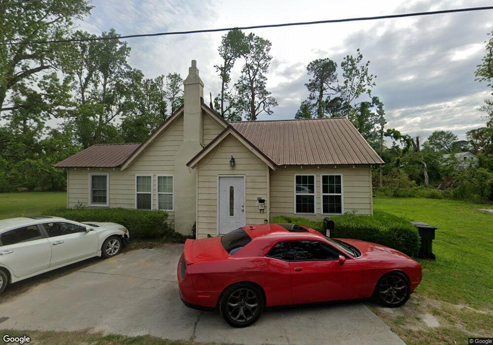
215 Bell St Swainsboro, GA 30401
Estimated Value: $61,619 - $91,000
3
Beds
1
Bath
1,113
Sq Ft
$69/Sq Ft
Est. Value
About This Home
This home is located at 215 Bell St, Swainsboro, GA 30401 and is currently estimated at $76,905, approximately $69 per square foot. 215 Bell St is a home located in Emanuel County with nearby schools including Swainsboro Primary School, Swainsboro Elementary School, and Swainsboro Middle School.
Ownership History
Date
Name
Owned For
Owner Type
Purchase Details
Closed on
Dec 14, 2015
Sold by
Ayala Jose
Bought by
Ayala Blanca E
Current Estimated Value
Purchase Details
Closed on
Oct 18, 2010
Sold by
Drb Realty & Properties Llc
Bought by
Ayala Jose
Purchase Details
Closed on
Feb 24, 2009
Sold by
Blount David and Blount Rhett
Bought by
Drb Realty & Properties Llc
Purchase Details
Closed on
Nov 23, 2005
Sold by
Cook Tonya Lynn Woods
Bought by
Blount David Rhett
Create a Home Valuation Report for This Property
The Home Valuation Report is an in-depth analysis detailing your home's value as well as a comparison with similar homes in the area
Home Values in the Area
Average Home Value in this Area
Purchase History
| Date | Buyer | Sale Price | Title Company |
|---|---|---|---|
| Ayala Blanca E | -- | -- | |
| Ayala Jose | $27,000 | -- | |
| Drb Realty & Properties Llc | -- | -- | |
| Blount David Rhett | $10,600 | -- | |
| Blount David Rhett | $10,667 | -- | |
| Blount David Rhett | $10,667 | -- |
Source: Public Records
Tax History Compared to Growth
Tax History
| Year | Tax Paid | Tax Assessment Tax Assessment Total Assessment is a certain percentage of the fair market value that is determined by local assessors to be the total taxable value of land and additions on the property. | Land | Improvement |
|---|---|---|---|---|
| 2024 | $756 | $19,262 | $1,035 | $18,227 |
| 2023 | $442 | $16,208 | $1,035 | $15,172 |
| 2022 | $344 | $13,873 | $1,035 | $12,838 |
| 2021 | $327 | $12,924 | $900 | $12,024 |
| 2020 | $316 | $11,815 | $2,052 | $9,763 |
| 2019 | $316 | $11,815 | $2,052 | $9,763 |
| 2018 | $312 | $11,815 | $2,052 | $9,763 |
| 2017 | $313 | $11,815 | $2,052 | $9,763 |
| 2016 | $313 | $11,804 | $2,052 | $9,752 |
| 2015 | -- | $11,912 | $2,160 | $9,752 |
| 2014 | -- | $11,761 | $2,160 | $9,601 |
| 2013 | -- | $11,244 | $2,160 | $9,083 |
Source: Public Records
Map
Nearby Homes
- 327 W Church St
- 219 Lucky St
- 316 W Moring St
- 323 N Main St
- 400 N Main St
- 402 N Main St
- 547 W Moring St
- 209 Price St
- 532 Calhoun St
- 331 S Green St
- 14.53 ACRES Gumlog Rd
- 423 E Martin Luther King Junior Blvd
- 625 N Main St
- 217 Fowler St
- 646 N Main St
- 555 Jordan Ln
- 629 Thompson Rd
- 508 Barbara Ave
- 118 Pierce Ave
- 625 Allen St Unit 12
- 0 Wadley Coleman Lake Rd Unit 7550639
- 0 Wadley Coleman Lake Rd Unit 259960
- 209 Bell St
- 307 W Church St
- 301 W Church St
- 305 W Church St
- 216 Bell St
- 212 Bell St
- 210 Bell St
- 214 College St
- 311 W Church St
- 206 Bell St
- 315 W St 192 St
- 227 W Church St
- 206 College St
- 302 W Church St
- 225 W Church St
- 212 College St
- 215 College St
- 312 W Church St