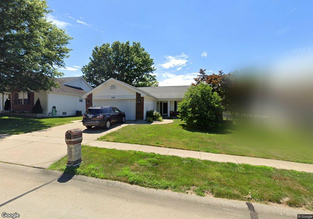
215 Birmingham Dr O Fallon, MO 63366
Estimated Value: $316,000 - $381,000
3
Beds
2
Baths
1,649
Sq Ft
$213/Sq Ft
Est. Value
About This Home
This home is located at 215 Birmingham Dr, O Fallon, MO 63366 and is currently estimated at $350,422, approximately $212 per square foot. 215 Birmingham Dr is a home located in St. Charles County with nearby schools including Joseph L. Mudd Elementary School, Forest Park Elementary School, and Fort Zumwalt North Middle School.
Ownership History
Date
Name
Owned For
Owner Type
Purchase Details
Closed on
Oct 22, 2002
Sold by
Brickles Earl D
Bought by
Brickles Pamela M
Current Estimated Value
Purchase Details
Closed on
Dec 14, 2001
Sold by
Brickles Earl D and Brickles Pamela M
Bought by
Brickles Pamela M
Home Financials for this Owner
Home Financials are based on the most recent Mortgage that was taken out on this home.
Original Mortgage
$108,000
Interest Rate
6.41%
Create a Home Valuation Report for This Property
The Home Valuation Report is an in-depth analysis detailing your home's value as well as a comparison with similar homes in the area
Home Values in the Area
Average Home Value in this Area
Purchase History
We collect this data history from publicly available records. To have your information removed, we recommend requesting removal directly through your county’s website.
| Date | Buyer | Sale Price | Title Company |
|---|---|---|---|
| Brickles Pamela M | -- | -- | |
| Brickles Pamela M | -- | -- |
Source: Public Records
Mortgage History
We collect this data history from publicly available records. To have your information removed, we recommend requesting removal directly through your county’s website.
| Date | Status | Borrower | Loan Amount |
|---|---|---|---|
| Previous Owner | Brickles Pamela M | $108,000 |
Source: Public Records
Tax History
| Year | Tax Paid | Tax Assessment Tax Assessment Total Assessment is a certain percentage of the fair market value that is determined by local assessors to be the total taxable value of land and additions on the property. | Land | Improvement |
|---|---|---|---|---|
| 2025 | $3,670 | $60,271 | -- | -- |
| 2023 | $3,671 | $55,434 | $0 | $0 |
| 2022 | $3,437 | $48,284 | $0 | $0 |
| 2021 | $3,440 | $48,284 | $0 | $0 |
| 2020 | $3,221 | $43,789 | $0 | $0 |
| 2019 | $3,229 | $43,789 | $0 | $0 |
| 2018 | $2,857 | $36,958 | $0 | $0 |
| 2017 | $2,818 | $36,958 | $0 | $0 |
| 2016 | $2,650 | $34,609 | $0 | $0 |
| 2015 | $2,464 | $34,609 | $0 | $0 |
| 2014 | $2,259 | $31,210 | $0 | $0 |
Source: Public Records
Map
Nearby Homes
- 328 Bristol Place
- 539 Galway Dr Unit 6B
- 415 Montbrook Dr
- 386 Westbrook Dr
- 727 Cordes St
- 714 Cordes St
- 0 Montbrook Dr
- 232 Sunset Villa Cir
- 205 E Elm St
- 2 Poe Ct
- 50 Chip Dr
- 807 Elaine Dr
- 710 Longfellow Cir
- 512 Sonderen St
- 413 Prince David Dr
- 886 Sherwood Forest Ct
- 846 Molloy Dr
- 269 Wabash Woods Way
- 105 Wabash Spur Dr
- 115 Wabash Spur Dr
- 219 Birmingham Dr
- 211 Birmingham Dr
- 214 Surrey Ct
- 210 Surrey Ct
- 223 Birmingham Dr
- 218 Surrey Ct
- 207 Birmingham Dr
- 214 Birmingham Dr
- 206 Surrey Ct
- 218 Birmingham Dr
- 222 Surrey Ct
- 210 Birmingham Dr
- 227 Birmingham Dr
- 222 Birmingham Dr
- 203 Birmingham Dr
- 206 Birmingham Dr
- 210 Westridge Dr
- 226 Surrey Ct
- 226 Birmingham Dr
- 301 Bristol Place
Your Personal Tour Guide
Ask me questions while you tour the home.