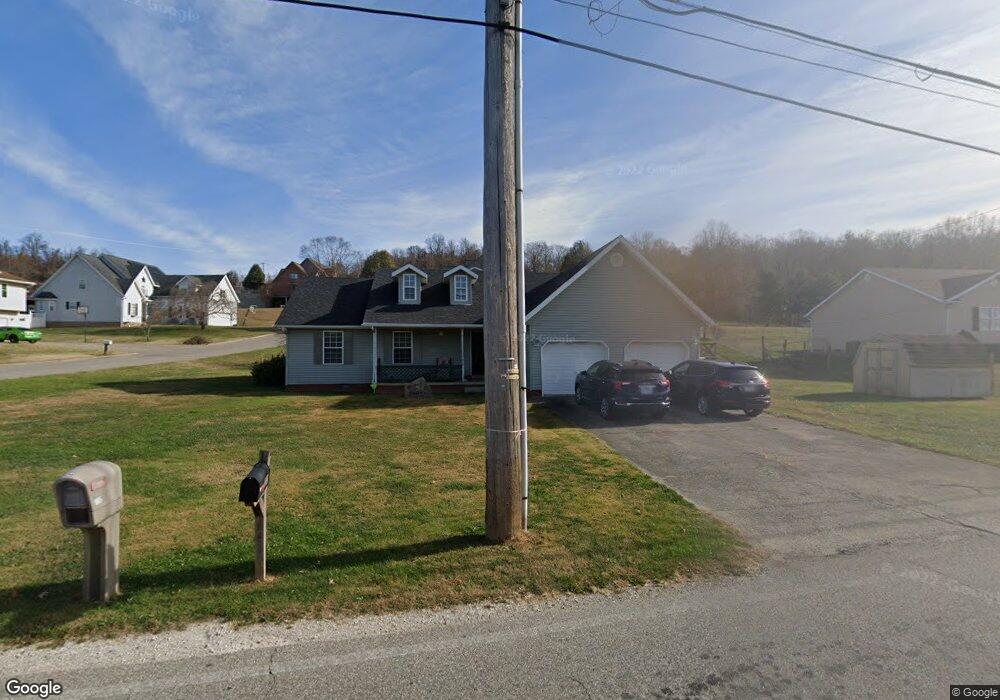
215 County Road 60 South Point, OH 45680
Estimated Value: $230,000 - $288,000
3
Beds
2
Baths
1,539
Sq Ft
$165/Sq Ft
Est. Value
About This Home
This home is located at 215 County Road 60, South Point, OH 45680 and is currently estimated at $253,791, approximately $164 per square foot. 215 County Road 60 is a home with nearby schools including South Point High School.
Ownership History
Date
Name
Owned For
Owner Type
Purchase Details
Closed on
Jan 10, 2018
Sold by
Smith Robert E C
Bought by
Sexton Alicia D
Current Estimated Value
Home Financials for this Owner
Home Financials are based on the most recent Mortgage that was taken out on this home.
Original Mortgage
$11,000
Outstanding Balance
$7,761
Interest Rate
3.93%
Mortgage Type
Purchase Money Mortgage
Estimated Equity
$246,030
Purchase Details
Closed on
Mar 13, 2002
Sold by
Leroy Andrew W
Bought by
Smith Robert E
Purchase Details
Closed on
Apr 4, 2000
Sold by
Sheets Kenneth R and Sheets Haze
Bought by
Leroy Andrew W
Purchase Details
Closed on
Apr 20, 1999
Sold by
Hayes Freddie L and Hayes Dan
Bought by
Sheets Kenneth R and Sheets Haze
Create a Home Valuation Report for This Property
The Home Valuation Report is an in-depth analysis detailing your home's value as well as a comparison with similar homes in the area
Home Values in the Area
Average Home Value in this Area
Purchase History
| Date | Buyer | Sale Price | Title Company |
|---|---|---|---|
| Sexton Alicia D | $60,033 | None Available | |
| Smith Robert E | $106,700 | -- | |
| Leroy Andrew W | $103,000 | -- | |
| Sheets Kenneth R | -- | -- |
Source: Public Records
Mortgage History
| Date | Status | Borrower | Loan Amount |
|---|---|---|---|
| Open | Sexton Alicia D | $11,000 |
Source: Public Records
Tax History Compared to Growth
Tax History
| Year | Tax Paid | Tax Assessment Tax Assessment Total Assessment is a certain percentage of the fair market value that is determined by local assessors to be the total taxable value of land and additions on the property. | Land | Improvement |
|---|---|---|---|---|
| 2024 | -- | $74,800 | $19,880 | $54,920 |
| 2023 | $2,538 | $74,800 | $19,880 | $54,920 |
| 2022 | $2,532 | $74,800 | $19,880 | $54,920 |
| 2021 | $2,282 | $62,650 | $18,650 | $44,000 |
| 2020 | $2,278 | $62,650 | $18,650 | $44,000 |
| 2019 | $2,265 | $62,650 | $18,650 | $44,000 |
| 2018 | $2,100 | $56,950 | $16,950 | $40,000 |
| 2017 | $2,096 | $56,950 | $16,950 | $40,000 |
| 2016 | $1,965 | $56,950 | $16,950 | $40,000 |
| 2015 | $2,100 | $57,060 | $16,950 | $40,110 |
| 2014 | $2,097 | $57,060 | $16,950 | $40,110 |
| 2013 | $1,893 | $57,060 | $16,950 | $40,110 |
Source: Public Records
Map
Nearby Homes
- 110 Kitts Ln
- 0 Township Road 161 Unit 182331
- 102 Park Ave
- 105 Orchard Dr
- 205 Michael St
- 408 Brubaker Dr
- 109 Delores Ave
- 108 Ferry St
- 101 Henray Dr
- 00 County Road 1
- 2904 County Road 1
- 0 Orchard Dr Unit Old Farme Subdivisio
- 1184 County Road 18
- 0 Twp R 135
- 609 4th St E
- 404 Township Road 135
- 0 Township Road 135
- 0 County Road 1
- 2800 Walnut St
- 314 Wadkins St