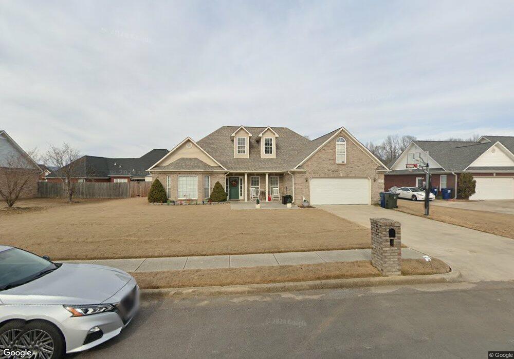
215 Deer Tracks Cir Owens Cross Roads, AL 35763
Estimated Value: $285,000 - $310,000
--
Bed
--
Bath
2,079
Sq Ft
$143/Sq Ft
Est. Value
About This Home
This home is located at 215 Deer Tracks Cir, Owens Cross Roads, AL 35763 and is currently estimated at $297,352, approximately $143 per square foot. 215 Deer Tracks Cir is a home with nearby schools including Owens Cross Roads Elementary School and New Hope High School.
Ownership History
Date
Name
Owned For
Owner Type
Purchase Details
Closed on
Jul 31, 2012
Sold by
Crout Karen W
Bought by
Banas Robert W and Banas Susan K
Current Estimated Value
Home Financials for this Owner
Home Financials are based on the most recent Mortgage that was taken out on this home.
Original Mortgage
$168,547
Outstanding Balance
$116,816
Interest Rate
3.68%
Mortgage Type
VA
Estimated Equity
$180,536
Purchase Details
Closed on
Oct 28, 2005
Sold by
Hamrick Frances G
Bought by
Crout Karen W
Create a Home Valuation Report for This Property
The Home Valuation Report is an in-depth analysis detailing your home's value as well as a comparison with similar homes in the area
Home Values in the Area
Average Home Value in this Area
Purchase History
| Date | Buyer | Sale Price | Title Company |
|---|---|---|---|
| Banas Robert W | $165,000 | None Available | |
| Crout Karen W | -- | -- |
Source: Public Records
Mortgage History
| Date | Status | Borrower | Loan Amount |
|---|---|---|---|
| Open | Banas Robert W | $168,547 |
Source: Public Records
Tax History Compared to Growth
Tax History
| Year | Tax Paid | Tax Assessment Tax Assessment Total Assessment is a certain percentage of the fair market value that is determined by local assessors to be the total taxable value of land and additions on the property. | Land | Improvement |
|---|---|---|---|---|
| 2024 | $739 | $22,380 | $4,500 | $17,880 |
| 2023 | $739 | $21,840 | $4,500 | $17,340 |
| 2022 | $716 | $18,860 | $3,000 | $15,860 |
| 2021 | $662 | $17,540 | $3,000 | $14,540 |
| 2020 | $630 | $16,740 | $3,000 | $13,740 |
| 2019 | $609 | $16,210 | $3,000 | $13,210 |
| 2018 | $605 | $16,120 | $0 | $0 |
| 2017 | $605 | $16,120 | $0 | $0 |
| 2016 | $605 | $16,120 | $0 | $0 |
| 2015 | $605 | $16,120 | $0 | $0 |
| 2014 | $617 | $16,420 | $0 | $0 |
Source: Public Records
Map
Nearby Homes
- 237 Chestnut Oak Cir
- 257 Dudley Ln
- 986 Cave Spring Rd
- 11 Acres Cave Spring Rd
- 5 U S 431
- 24 Acres U S 431
- 156 Dudley Ln Unit A1-4, B
- 361 Piney Woods Rd
- 3 acres Highway 431 S
- 128 Vulcan St
- 126 Vulcan St
- 124 Vulcan St
- The Butler Plan at Ramsay Cove
- The Franklin Plan at Ramsay Cove
- The Shelby A Plan at Ramsay Cove
- The Chelsea A Plan at Ramsay Cove
- The Daphne Plan at Ramsay Cove
- The Everett Plan at Ramsay Cove
- DUPONT Plan at Ramsay Cove
- Woodruff Plan at Ramsay Cove
- 213 Deer Tracks Cir
- 235 Deer Tracks Cir
- 217 Deer Tracks Cir
- 237 Deer Tracks Cir
- 102 Buck Path Ln
- 211 Deer Tracks Cir
- 216 Deer Tracks Cir
- 223 Deer Tracks Cir
- 102 Spike St
- 231 Deer Tracks Cir
- 238 Deer Tracks Cir
- 218 Deer Tracks Cir
- 527 Wilson Mann Rd
- 519 Wilson Mann Rd
- 236 Deer Tracks Cir
- 539 Wilson Mann Rd
- 208 Deer Tracks Cir
- 511 Wilson Mann Rd
- 220 Deer Tracks Cir
- 207 Deer Tracks Cir