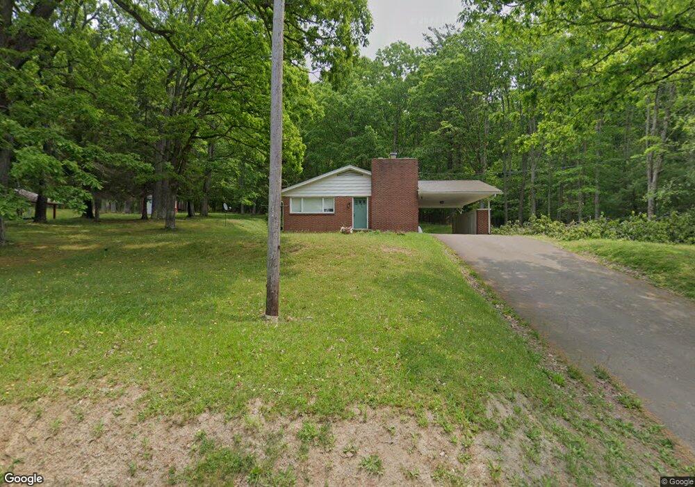
215 N Bradley Ln Oakland, MD 21550
Estimated Value: $173,678 - $273,000
--
Bed
2
Baths
1,232
Sq Ft
$179/Sq Ft
Est. Value
About This Home
This home is located at 215 N Bradley Ln, Oakland, MD 21550 and is currently estimated at $219,920, approximately $178 per square foot. 215 N Bradley Ln is a home located in Garrett County with nearby schools including Broad Ford Elementary School, Southern Middle School, and Southern Garrett High School.
Ownership History
Date
Name
Owned For
Owner Type
Purchase Details
Closed on
Jul 14, 2004
Sold by
Rs Rs S and Rs John N
Bought by
Moore James R and Bray Carl R
Current Estimated Value
Purchase Details
Closed on
Dec 31, 1996
Sold by
Evans M Cynthia
Bought by
Sanders John N and Cynthia Sanders M
Purchase Details
Closed on
Sep 20, 1994
Sold by
Orr Richard B
Bought by
Evans M Cynthia
Create a Home Valuation Report for This Property
The Home Valuation Report is an in-depth analysis detailing your home's value as well as a comparison with similar homes in the area
Home Values in the Area
Average Home Value in this Area
Purchase History
| Date | Buyer | Sale Price | Title Company |
|---|---|---|---|
| Moore James R | $125,000 | -- | |
| Sanders John N | -- | -- | |
| Evans M Cynthia | $78,500 | -- |
Source: Public Records
Mortgage History
| Date | Status | Borrower | Loan Amount |
|---|---|---|---|
| Closed | Evans M Cynthia | -- |
Source: Public Records
Tax History Compared to Growth
Tax History
| Year | Tax Paid | Tax Assessment Tax Assessment Total Assessment is a certain percentage of the fair market value that is determined by local assessors to be the total taxable value of land and additions on the property. | Land | Improvement |
|---|---|---|---|---|
| 2025 | $2,607 | $162,500 | $23,700 | $138,800 |
| 2024 | $2,510 | $153,033 | $0 | $0 |
| 2023 | $2,355 | $143,567 | $0 | $0 |
| 2022 | $2,199 | $134,100 | $23,700 | $110,400 |
| 2021 | $2,191 | $133,567 | $0 | $0 |
| 2020 | $2,182 | $133,033 | $0 | $0 |
| 2019 | $2,173 | $132,500 | $23,700 | $108,800 |
| 2018 | $2,085 | $132,500 | $23,700 | $108,800 |
| 2017 | $2,085 | $132,500 | $0 | $0 |
| 2016 | -- | $134,500 | $0 | $0 |
| 2015 | -- | $134,500 | $0 | $0 |
| 2014 | -- | $134,500 | $0 | $0 |
Source: Public Records
Map
Nearby Homes
- 0 Crosby Dr Unit 64/65
- 0 Sam Snead Cir Unit 1 MDGA2010358
- 62 Crosby Dr
- 511 E Green St
- 503 E Alder St
- 315 Coolidge Ave
- 163 Mitchell Dr
- 0 8th & Dennett Road St Unit MDGA2009886
- 611 E Oak St
- 5202 Hutton Rd
- 627 Hamill St
- 163 Crestview Dr
- 11 Sunset Dr
- 1056 Sunrise Dr
- 13209 Garrett Hwy
- 0 Memorial Dr Unit MDGA2010668
- 127 S Oakhall Dr
- 609 Southern Pines Dr
- 697 Monte Vista Rd
- 723 Kings Ct
- 225 N Bradley Ln
- 222 N Bradley Ln
- 395 Woodland Dr
- 233 N Bradley Ln
- 238 N Bradley Ln
- 302 Woodland Dr
- 137 N Bradley Ln
- 240 N Bradley Ln
- 304 Woodland Dr
- 303 Woodland Dr
- 259 N Bradley Ln
- 250 N Bradley Ln
- 135 N Bradley Ln
- 306 Woodland Dr
- 533 Glade Square
- 265 N Bradley Ln
- 77 W Pennington St
- 400 Glade Square
- 209 W Pennington St
- 127 W Pennington St