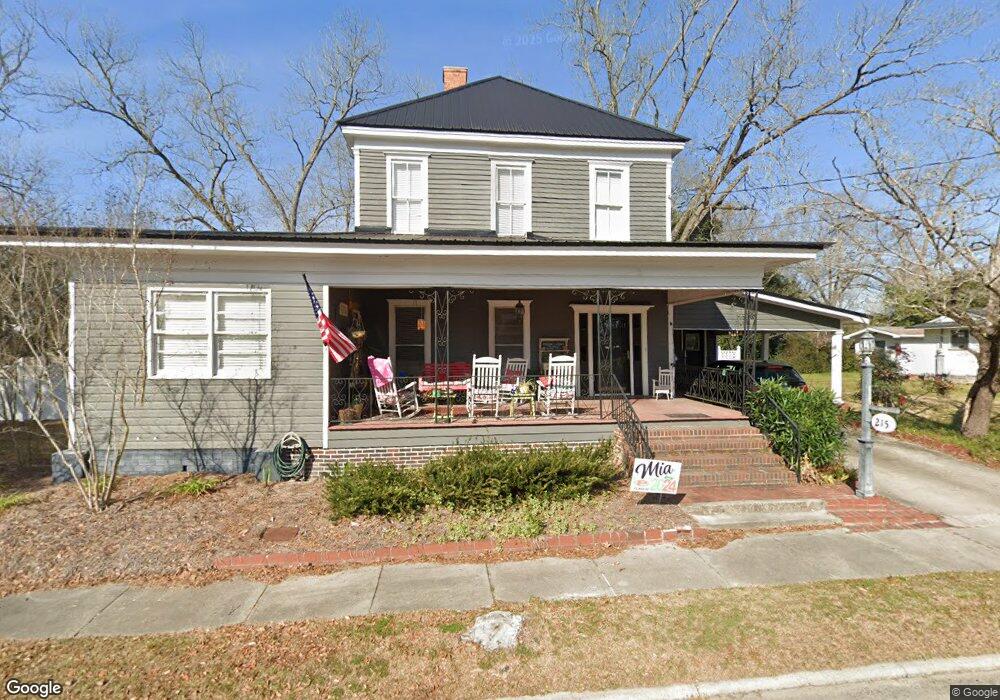
215 N Smith St Claxton, GA 30417
Estimated Value: $195,000 - $227,000
3
Beds
2
Baths
2,585
Sq Ft
$79/Sq Ft
Est. Value
About This Home
This home is located at 215 N Smith St, Claxton, GA 30417 and is currently estimated at $204,075, approximately $78 per square foot. 215 N Smith St is a home with nearby schools including Claxton Elementary School, Second Chance, and Claxton Middle School.
Ownership History
Date
Name
Owned For
Owner Type
Purchase Details
Closed on
Mar 28, 2006
Sold by
Anners Jeffrey Mark
Bought by
Anderson Bernie D and Anderson Hilda E
Current Estimated Value
Home Financials for this Owner
Home Financials are based on the most recent Mortgage that was taken out on this home.
Original Mortgage
$70,290
Interest Rate
6.2%
Purchase Details
Closed on
Sep 20, 1996
Sold by
Hearn Grace F Mrs
Bought by
Anners Jeffrey Mark
Purchase Details
Closed on
Jan 1, 1925
Bought by
Hearn Grace F Mrs
Create a Home Valuation Report for This Property
The Home Valuation Report is an in-depth analysis detailing your home's value as well as a comparison with similar homes in the area
Home Values in the Area
Average Home Value in this Area
Purchase History
| Date | Buyer | Sale Price | Title Company |
|---|---|---|---|
| Anderson Bernie D | $69,500 | -- | |
| Anners Jeffrey Mark | $58,000 | -- | |
| Hearn Grace F Mrs | -- | -- |
Source: Public Records
Mortgage History
| Date | Status | Borrower | Loan Amount |
|---|---|---|---|
| Closed | Anderson Bernie D | $70,290 |
Source: Public Records
Tax History Compared to Growth
Tax History
| Year | Tax Paid | Tax Assessment Tax Assessment Total Assessment is a certain percentage of the fair market value that is determined by local assessors to be the total taxable value of land and additions on the property. | Land | Improvement |
|---|---|---|---|---|
| 2024 | $1,486 | $62,328 | $11,960 | $50,368 |
| 2023 | $1,502 | $49,880 | $12,080 | $37,800 |
| 2022 | $1,405 | $49,880 | $12,080 | $37,800 |
| 2021 | $1,528 | $49,880 | $12,080 | $37,800 |
| 2020 | $1,533 | $49,880 | $12,080 | $37,800 |
| 2019 | $1,489 | $49,880 | $12,080 | $37,800 |
| 2018 | $1,492 | $49,880 | $12,080 | $37,800 |
| 2017 | $1,451 | $49,880 | $12,080 | $37,800 |
| 2016 | $1,293 | $43,752 | $14,120 | $29,632 |
| 2015 | -- | $44,312 | $14,120 | $30,192 |
| 2014 | -- | $44,312 | $14,120 | $30,192 |
| 2013 | -- | $44,312 | $14,120 | $30,192 |
Source: Public Records
Map
Nearby Homes
- 147 Creek Ridge Rd
- 179 Creek Ridge Rd
- 19 Collins St
- 1302 Jim Sapp Rd
- 29 Grove Ln
- 4909 Perry Rd
- 0 Turnpike Rd Unit SA339603
- 319 A Rupert Wood Ln
- 15683 Ga Highway 129 N
- 47 Manassas Station Rd
- 62 Manassas Station Rd
- 0 Dublin Rd
- 92 Graham Ln
- 308 Old Metter Rd
- 628 Riverside Dr
- 4164 Perry Rd
- 19 Wysteria Ln
- 1200 Riverside Dr
- 610 W Liberty St
- 606 Park Ave
- 211 N North Smith St
- 219 N Smith St
- 211 N Smith St
- 216 N Smith St
- 212 N Smith St
- 223 N Smith St
- 213 Blalock St
- 222 N Smith St
- N Smith St
- 210 Blalock St
- 209 Blalock St
- 1329 Bernie Anderson Hwy
- 228 N Smith St
- 205 Blalock St
- 201 Blalock St
- 231 N Smith St
- 303 Hearn St
- 232 N Smith St
- 235 N Smith St
- 206 Hearn St