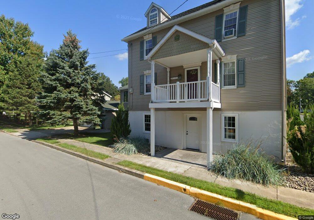
215 S 2nd St Selinsgrove, PA 17870
Estimated Value: $216,000 - $268,000
--
Bed
--
Bath
--
Sq Ft
0.46
Acres
About This Home
This home is located at 215 S 2nd St, Selinsgrove, PA 17870 and is currently estimated at $245,514. 215 S 2nd St is a home located in Snyder County with nearby schools including Selinsgrove Area Elementary School, Selinsgrove Intermediate School, and Selinsgrove Area Middle School.
Ownership History
Date
Name
Owned For
Owner Type
Purchase Details
Closed on
Sep 30, 2025
Sold by
Shambach Brian and Wenrich Sara J
Bought by
Shambach Brian
Current Estimated Value
Home Financials for this Owner
Home Financials are based on the most recent Mortgage that was taken out on this home.
Original Mortgage
$236,060
Outstanding Balance
$236,060
Interest Rate
6.56%
Mortgage Type
FHA
Estimated Equity
$9,454
Purchase Details
Closed on
Dec 29, 2023
Sold by
Schrader Richard D
Bought by
Shambach Brian and Wenrich Sara J
Home Financials for this Owner
Home Financials are based on the most recent Mortgage that was taken out on this home.
Original Mortgage
$185,600
Interest Rate
7.44%
Mortgage Type
New Conventional
Purchase Details
Closed on
Feb 16, 2012
Sold by
Schrader Ricahrd D
Bought by
Reinard Mark A and Reinard Brenda K
Home Financials for this Owner
Home Financials are based on the most recent Mortgage that was taken out on this home.
Original Mortgage
$97,000
Interest Rate
3.93%
Create a Home Valuation Report for This Property
The Home Valuation Report is an in-depth analysis detailing your home's value as well as a comparison with similar homes in the area
Home Values in the Area
Average Home Value in this Area
Purchase History
| Date | Buyer | Sale Price | Title Company |
|---|---|---|---|
| Shambach Brian | -- | None Listed On Document | |
| Shambach Brian | $240,000 | None Listed On Document | |
| Reinard Mark A | -- | -- |
Source: Public Records
Mortgage History
| Date | Status | Borrower | Loan Amount |
|---|---|---|---|
| Open | Shambach Brian | $236,060 | |
| Previous Owner | Shambach Brian | $185,600 | |
| Previous Owner | Reinard Mark A | $97,000 |
Source: Public Records
Tax History Compared to Growth
Tax History
| Year | Tax Paid | Tax Assessment Tax Assessment Total Assessment is a certain percentage of the fair market value that is determined by local assessors to be the total taxable value of land and additions on the property. | Land | Improvement |
|---|---|---|---|---|
| 2025 | $1,340 | $11,200 | $1,950 | $9,250 |
| 2024 | $1,258 | $11,200 | $1,950 | $9,250 |
| 2023 | $502 | $11,200 | $1,950 | $9,250 |
| 2022 | $1,207 | $11,200 | $1,950 | $9,250 |
| 2021 | $1,196 | $11,200 | $1,950 | $9,250 |
| 2020 | $1,191 | $11,200 | $1,950 | $9,250 |
| 2019 | $1,185 | $11,200 | $1,950 | $9,250 |
| 2018 | $1,174 | $11,200 | $1,950 | $9,250 |
| 2017 | $1,117 | $10,760 | $1,950 | $8,810 |
| 2016 | $601 | $10,760 | $1,950 | $8,810 |
| 2015 | $39,610 | $10,760 | $1,950 | $8,810 |
| 2014 | $39,610 | $10,760 | $1,950 | $8,810 |
Source: Public Records
Map
Nearby Homes
- 301 E Pine St
- 223 E Pine St
- 00 S Market St
- 211 W Pine St
- 207 Orange St Unit 209
- 500 N Orange St
- 511 N 10th St
- 722 N 8th St
- 12 Minton Dr
- 0 Wedgewood Dr
- Lot 1 522 Route S
- 9130 State Route 147
- 321 Pleasant Dr
- 210 Airport Rd
- 20 Quarry Rd
- 00 Market
- 1262 N Old Trail
- 456 State School Rd
- 0 Roosevelt Ave
- 0 Mill Rd
- 309 E Bough St
- 304 Cranberry Alley
- 300 E Bough St
- 213 E Bough St
- 304 E Bough St
- 211 E Bough St
- 315 E Bough St
- 223 E Walnut St
- 208 E Bough St
- 217 E Walnut St
- 305 E Walnut St
- 312 E Bough St
- 215 E Walnut St
- 213 E Walnut St
- 206 E Bough St
- 203 E Bough St
- 209 E Walnut St
- 315 E Walnut St Unit A
- 113 S 3rd St
- 115 S 3rd St