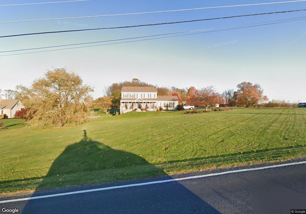
215 S Locust Point Rd Mechanicsburg, PA 17055
Estimated Value: $422,604 - $455,000
4
Beds
3
Baths
2,016
Sq Ft
$217/Sq Ft
Est. Value
About This Home
This home is located at 215 S Locust Point Rd, Mechanicsburg, PA 17055 and is currently estimated at $437,401, approximately $216 per square foot. 215 S Locust Point Rd is a home located in Cumberland County with nearby schools including Monroe Elementary School, Eagle View Middle School, and Cumberland Valley High School.
Ownership History
Date
Name
Owned For
Owner Type
Purchase Details
Closed on
May 28, 2010
Sold by
Graham William E
Bought by
Bongs Christopher C
Current Estimated Value
Home Financials for this Owner
Home Financials are based on the most recent Mortgage that was taken out on this home.
Original Mortgage
$197,600
Outstanding Balance
$133,403
Interest Rate
5.12%
Mortgage Type
New Conventional
Estimated Equity
$303,998
Create a Home Valuation Report for This Property
The Home Valuation Report is an in-depth analysis detailing your home's value as well as a comparison with similar homes in the area
Home Values in the Area
Average Home Value in this Area
Purchase History
| Date | Buyer | Sale Price | Title Company |
|---|---|---|---|
| Bongs Christopher C | $247,000 | -- |
Source: Public Records
Mortgage History
| Date | Status | Borrower | Loan Amount |
|---|---|---|---|
| Open | Bongs Christopher C | $197,600 |
Source: Public Records
Tax History Compared to Growth
Tax History
| Year | Tax Paid | Tax Assessment Tax Assessment Total Assessment is a certain percentage of the fair market value that is determined by local assessors to be the total taxable value of land and additions on the property. | Land | Improvement |
|---|---|---|---|---|
| 2025 | $3,830 | $247,600 | $81,000 | $166,600 |
| 2024 | $3,636 | $247,600 | $81,000 | $166,600 |
| 2023 | $3,444 | $247,600 | $81,000 | $166,600 |
| 2022 | $3,355 | $247,600 | $81,000 | $166,600 |
| 2021 | $3,280 | $247,600 | $81,000 | $166,600 |
| 2020 | $3,216 | $247,600 | $81,000 | $166,600 |
| 2019 | $3,140 | $247,600 | $81,000 | $166,600 |
| 2018 | $3,078 | $247,600 | $81,000 | $166,600 |
| 2017 | $3,021 | $247,600 | $81,000 | $166,600 |
| 2016 | -- | $247,600 | $81,000 | $166,600 |
| 2015 | -- | $247,600 | $81,000 | $166,600 |
| 2014 | -- | $247,600 | $81,000 | $166,600 |
Source: Public Records
Map
Nearby Homes
- 723 Brindle Farm Ln
- 724 Brindle Farm Ln
- 253 Brindle Rd
- Emersyn Plan at Brindle Farms Estates
- Woodvale Plan at Brindle Farms Estates
- Cartwright Plan at Brindle Farms Estates
- Abigail Plan at Brindle Farms Estates
- Hudson Plan at Brindle Farms Estates
- Leighton Plan at Brindle Farms Estates
- Huntleigh Plan at Brindle Farms Estates
- Ashland Plan at Brindle Farms Estates
- 220 Maple Ln
- 1221 Minnich Rd
- 2160 S Autumn Chase Dr
- Charlotte Plan at Trindle Place
- Wesley Plan at Trindle Place
- Kingston Plan at Trindle Place
- Hunter Plan at Trindle Place
- Stonecroft Plan at Trindle Place
- Darien Plan at Trindle Place
- 219 S Locust Point Rd
- 209 S Locust Point Rd
- 203 S Locust Point Rd
- 197 S Locust Point Rd
- 191 S Locust Point Rd
- 190 S Locust Point Rd
- 200 Clouser Rd
- 208 Clouser Rd
- 212 Clouser Rd
- 204 Clouser Rd
- 196 Clouser Rd
- 207 Clouser Rd
- 269 Clouser Rd
- 210 Clouser Rd
- 214 Clouser Rd
- 195 Clouser Rd
- 188 Clouser Rd
- 182 Clouser Rd
- 273 Clouser Rd
- 189 Clouser Rd